Accueil Foire Aux Questions Trouver d'autres membres Rechercher Utilisez le vBpad pour stocker des notes personnelles Ici, vous pouvez voir les sujets auxquels vous avez souscris, vos messages privés; et modifier vos informations personnelles et préférences. Statistiques du forum Enregistrez vous gratuitement ! Se déconnecter  
Forum OXMO Forum OXMO > Section Généraliste > Discussion Libre > Je vous parle en direct de Mars (Opportunity a atterri !)


Aller au Forum:
Notez ce sujet :

Page(s) (49): [ <<   <   10   11   12   13   14   15   16   17   18   19   20   21   22   23   24   25   26   27   28   >   >> ]   Sujet précédent   Sujet suivant
Auteur
Sujet Poster un nouveau sujet    Poster une réponse
 Seth  Rechercher tous les messages de ce membre Cliquez ici pour envoyer un message privé à cet utilisateur
Confirmé

Déconnecté

Niveau : 3
N° de Membre : 1512

Ancienneté : 100%
Participation : 2%
Inscription: 07 May 2002
Localisation:
Messages: 1390
Sujets Lancés : 70


http://photojournal.jpl.nasa.gov/jp...5224_modest.jpg

Citation:
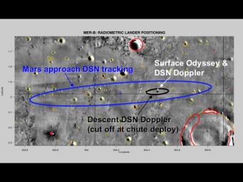
This map of the Mars Exploration Rover Opportunity's new neighborhood at Meridiani Planum, Mars, demonstrates how engineers honed in on the location of the rover. The larger blue ellipse shows the projected landing area just before arriving at Mars. The black ellipse denotes the first approximation of the rover's location after landing based on radio signals received by NASA's Deep Space Network during entry, descent and landing. The white cross points to the rover's precise location based on radio signals sent from the surface both directly to Earth through the Deep Space Network and through NASA's Mars Odyssey orbiter


PS: Nice pictures Benmars


__________________


Signaler ce message à un modérateur | IP: Logguée
Temps en ligne : 8 Jours, 15 Heures, 44 Minutes, 21 Secondes en ligne

Old Post 09-02-2004 22:14
Cliquez ici pour voir le profil de Seth Cliquez ici pour lui envoyer un message privé  Trouver plus de messages de Seth Ajouter Seth à votre liste d'amis Editer/Effacer le Message Citer le message dans la réponse
 Seth  Rechercher tous les messages de ce membre Cliquez ici pour envoyer un message privé à cet utilisateur
Confirmé

Déconnecté

Niveau : 3
N° de Membre : 1512

Ancienneté : 100%
Participation : 2%
Inscription: 07 May 2002
Localisation:
Messages: 1390
Sujets Lancés : 70


http://photojournal.jpl.nasa.gov/jp...5227_modest.jpg

Citation:
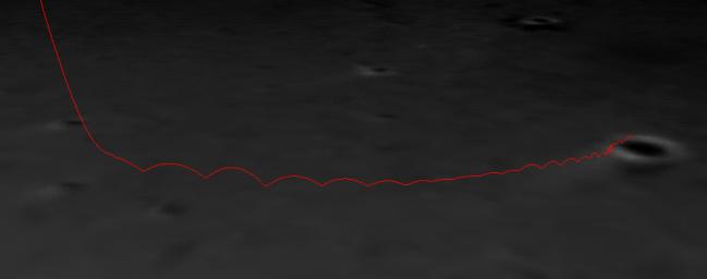
In this close-up view of the path Opportunity took when it landed at Meridiani Planum, Mars, a computer-generated red line shows the spacecraft's bounce motions as it landed at Meridiani Planum, Mars. The spacecraft bounced north approximately 26 times while safely encased in airbags, until it came to a stop inside the crater to the right of the image. The red line is superimposed on a mosaic of the three images taken during descent by the descent image motion estimation system camera, located on the bottom of the lander.


__________________


Signaler ce message à un modérateur | IP: Logguée
Temps en ligne : 8 Jours, 15 Heures, 44 Minutes, 21 Secondes en ligne

Old Post 09-02-2004 22:15
Cliquez ici pour voir le profil de Seth Cliquez ici pour lui envoyer un message privé  Trouver plus de messages de Seth Ajouter Seth à votre liste d'amis Editer/Effacer le Message Citer le message dans la réponse
 Seth  Rechercher tous les messages de ce membre Cliquez ici pour envoyer un message privé à cet utilisateur
Confirmé

Déconnecté

Niveau : 3
N° de Membre : 1512

Ancienneté : 100%
Participation : 2%
Inscription: 07 May 2002
Localisation:
Messages: 1390
Sujets Lancés : 70


http://photojournal.jpl.nasa.gov/jp...5228_modest.jpg
PIA05228.tif (63.7 MB): http://photojournal.jpl.nasa.gov/tiff/PIA05228.tif

Citation:
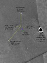
This map of the Mars Exploration Rover Opportunity's new neighborhood at Meridiani Planum, Mars, shows the surface features used to locate the rover. By imaging these "bumps" on the horizon from the perspective of the rover, mission members were able to pin down the rover's precise location. The image consists of data from the Mars Global Surveyor orbiter, the Mars Odyssey orbiter and the descent image motion estimation system located on the bottom of the rover.


__________________


Signaler ce message à un modérateur | IP: Logguée
Temps en ligne : 8 Jours, 15 Heures, 44 Minutes, 21 Secondes en ligne

Old Post 09-02-2004 22:16
Cliquez ici pour voir le profil de Seth Cliquez ici pour lui envoyer un message privé  Trouver plus de messages de Seth Ajouter Seth à votre liste d'amis Editer/Effacer le Message Citer le message dans la réponse
 Seth  Rechercher tous les messages de ce membre Cliquez ici pour envoyer un message privé à cet utilisateur
Confirmé

Déconnecté

Niveau : 3
N° de Membre : 1512

Ancienneté : 100%
Participation : 2%
Inscription: 07 May 2002
Localisation:
Messages: 1390
Sujets Lancés : 70


http://photojournal.jpl.nasa.gov/jp...5229_modest.jpg


http://photojournal.jpl.nasa.gov/fi...05229_label.jpg


Citation:
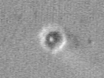
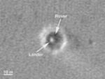
This map of the Mars Exploration Rover Opportunity's new neighborhood at Meridiani Planum, Mars shows remnants of the rover's landing, including its lander; backshell and parachute; first bounce mark; and the site where its heat shield hit the surface (see inset for exact locations). The image was taken by a camera onboard the Mars Global Surveyor orbiter.


__________________


Signaler ce message à un modérateur | IP: Logguée
Temps en ligne : 8 Jours, 15 Heures, 44 Minutes, 21 Secondes en ligne

Old Post 09-02-2004 22:18
Cliquez ici pour voir le profil de Seth Cliquez ici pour lui envoyer un message privé  Trouver plus de messages de Seth Ajouter Seth à votre liste d'amis Editer/Effacer le Message Citer le message dans la réponse
 Seth  Rechercher tous les messages de ce membre Cliquez ici pour envoyer un message privé à cet utilisateur
Confirmé

Déconnecté

Niveau : 3
N° de Membre : 1512

Ancienneté : 100%
Participation : 2%
Inscription: 07 May 2002
Localisation:
Messages: 1390
Sujets Lancés : 70


http://photojournal.jpl.nasa.gov/jp...5230_modest.jpg
PIA05230.tif (1.081 MB): http://photojournal.jpl.nasa.gov/tiff/PIA05230.tif


http://photojournal.jpl.nasa.gov/fi...05230_label.jpg


Citation:
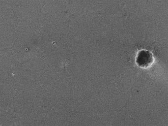
This map shows the Mars Exploration Rover Opportunity and its lander on the surface of Mars. The robotic geologist landed inside a small crater at Meridiani Planum on Jan. 24, 2004, PST. The white spot is the lander, and the small black spot northeast of it is believed to be the rover (see inset). The image was taken by a camera onboard the Mars Global Surveyor orbiter.


__________________


Signaler ce message à un modérateur | IP: Logguée
Temps en ligne : 8 Jours, 15 Heures, 44 Minutes, 21 Secondes en ligne

Old Post 09-02-2004 22:20
Cliquez ici pour voir le profil de Seth Cliquez ici pour lui envoyer un message privé  Trouver plus de messages de Seth Ajouter Seth à votre liste d'amis Editer/Effacer le Message Citer le message dans la réponse
 Seth  Rechercher tous les messages de ce membre Cliquez ici pour envoyer un message privé à cet utilisateur
Confirmé

Déconnecté

Niveau : 3
N° de Membre : 1512

Ancienneté : 100%
Participation : 2%
Inscription: 07 May 2002
Localisation:
Messages: 1390
Sujets Lancés : 70


http://photojournal.jpl.nasa.gov/jp...5232_modest.jpg
PIA05232.tif (2.363 MB): http://photojournal.jpl.nasa.gov/tiff/PIA05232.tif

Citation:
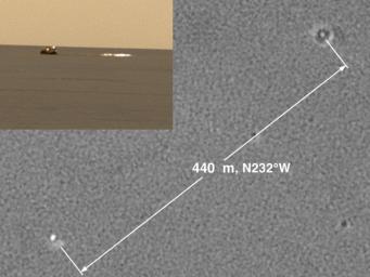
This image shows two views of the backshell and parachute that helped deliver the Mars Exploration Rover Opportunity safely to the surface of Mars. The first, seen in the top left picture, is from the rover's perspective inside the small crater where it landed. The second, seen in the center, is from above and was taken by a camera onboard the Mars Global Surveyor orbiter. The white spot inside the crater in the upper right corner is the rover's lander, and the white mark in the lower left corner is the backshell.


__________________


Signaler ce message à un modérateur | IP: Logguée
Temps en ligne : 8 Jours, 15 Heures, 44 Minutes, 21 Secondes en ligne

Old Post 09-02-2004 22:41
Cliquez ici pour voir le profil de Seth Cliquez ici pour lui envoyer un message privé  Trouver plus de messages de Seth Ajouter Seth à votre liste d'amis Editer/Effacer le Message Citer le message dans la réponse
 Seth  Rechercher tous les messages de ce membre Cliquez ici pour envoyer un message privé à cet utilisateur
Confirmé

Déconnecté

Niveau : 3
N° de Membre : 1512

Ancienneté : 100%
Participation : 2%
Inscription: 07 May 2002
Localisation:
Messages: 1390
Sujets Lancés : 70


http://photojournal.jpl.nasa.gov/jp...5233_modest.jpg
PIA05233.tif (1.575 MB): http://photojournal.jpl.nasa.gov/tiff/PIA05233.tif

Citation:
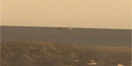
From its new location at the inner edge of the small crater surrounding it, the Mars Exploration Rover Opportunity was able to look out to the plains where its backshell (left) and parachute (right) landed. Opportunity is currently investigating a rock outcropping with its suite of robotic geologic tools. This approximate true-color image was created by combining data from the panoramic camera's red, green and blue filters.


__________________


Signaler ce message à un modérateur | IP: Logguée
Temps en ligne : 8 Jours, 15 Heures, 44 Minutes, 21 Secondes en ligne

Old Post 09-02-2004 22:42
Cliquez ici pour voir le profil de Seth Cliquez ici pour lui envoyer un message privé  Trouver plus de messages de Seth Ajouter Seth à votre liste d'amis Editer/Effacer le Message Citer le message dans la réponse
 Seth  Rechercher tous les messages de ce membre Cliquez ici pour envoyer un message privé à cet utilisateur
Confirmé

Déconnecté

Niveau : 3
N° de Membre : 1512

Ancienneté : 100%
Participation : 2%
Inscription: 07 May 2002
Localisation:
Messages: 1390
Sujets Lancés : 70

So many pictures today ^o^


http://photojournal.jpl.nasa.gov/jp...5234_modest.jpg
PIA05234.tif (40.79 MB): http://photojournal.jpl.nasa.gov/tiff/PIA05234.tif

Citation:
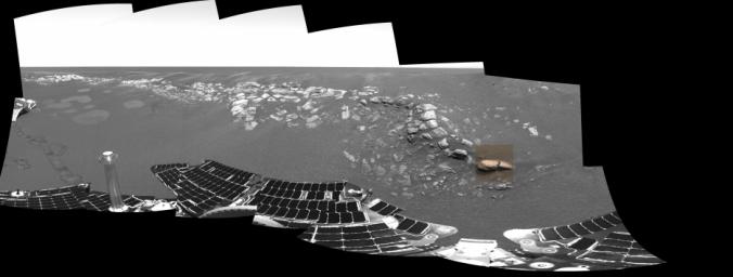
The colored square in this grayscale image taken by the panoramic camera onboard the Mars Exploration Rover Opportunity highlights the location of Stone Mountain, located within the rock outcrop at Meridiani Planum, Mars. Scientists are examining Stone Mountain with the instruments on the rover's instrument deployment device, or "arm," in search of clues about the composition of the rock outcrop.


__________________


Signaler ce message à un modérateur | IP: Logguée
Temps en ligne : 8 Jours, 15 Heures, 44 Minutes, 21 Secondes en ligne

Old Post 10-02-2004 00:09
Cliquez ici pour voir le profil de Seth Cliquez ici pour lui envoyer un message privé  Trouver plus de messages de Seth Ajouter Seth à votre liste d'amis Editer/Effacer le Message Citer le message dans la réponse
 Seth  Rechercher tous les messages de ce membre Cliquez ici pour envoyer un message privé à cet utilisateur
Confirmé

Déconnecté

Niveau : 3
N° de Membre : 1512

Ancienneté : 100%
Participation : 2%
Inscription: 07 May 2002
Localisation:
Messages: 1390
Sujets Lancés : 70


http://photojournal.jpl.nasa.gov/jp...5235_modest.jpg
PIA05235.tif (3.156 MB): http://photojournal.jpl.nasa.gov/tiff/PIA05235.tif

Citation:
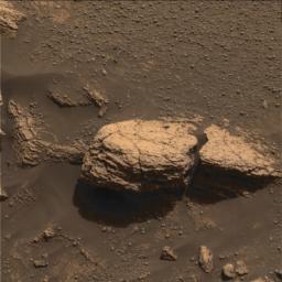
This color image taken by the panoramic camera onboard the Mars Exploration Rover Opportunity shows the part of the rock outcrop dubbed Stone Mountain at Meridiani Planum, Mars. Scientists are examining Stone Mountain with the instruments on the rover's instrument deployment device, or "arm," in search of clues about the composition of the rock outcrop.


http://photojournal.jpl.nasa.gov/fi...ntext-B16R1.jpg

Citation:
The colorless square in this color image of the martian rock formation called Stone Mountain is one portion of the rock being analyzed with tools on the Mars Exploration Rover Opportunity's instrument deployment device, or "arm." The square area is approximately 3 centimeters (1.2 inches) across. Stone Mountain is located within the rock outcrop on Meridiani Planum, Mars. The image was taken by the rover's panoramic camera.


__________________


Signaler ce message à un modérateur | IP: Logguée
Temps en ligne : 8 Jours, 15 Heures, 44 Minutes, 21 Secondes en ligne

Old Post 10-02-2004 00:11
Cliquez ici pour voir le profil de Seth Cliquez ici pour lui envoyer un message privé  Trouver plus de messages de Seth Ajouter Seth à votre liste d'amis Editer/Effacer le Message Citer le message dans la réponse
 Seth  Rechercher tous les messages de ce membre Cliquez ici pour envoyer un message privé à cet utilisateur
Confirmé

Déconnecté

Niveau : 3
N° de Membre : 1512

Ancienneté : 100%
Participation : 2%
Inscription: 07 May 2002
Localisation:
Messages: 1390
Sujets Lancés : 70


http://photojournal.jpl.nasa.gov/jp...5237_modest.jpg
PIA05237.tif (1.05 MB): http://photojournal.jpl.nasa.gov/tiff/PIA05237.tif

Citation:
This sharp, close-up image taken by the microscopic imager on the Mars Exploration Rover Opportunity's instrument deployment device, or "arm," shows a rock target dubbed "Robert E," located on the rock outcrop at Meridiani Planum, Mars. Scientists are studying this area for clues about the rock outcrop's composition. This image measures 3 centimeters (1.2 inches) across and was taken on the 15th day of Opportunity's journey (Feb. 8, 2004).


__________________


Signaler ce message à un modérateur | IP: Logguée
Temps en ligne : 8 Jours, 15 Heures, 44 Minutes, 21 Secondes en ligne

Old Post 10-02-2004 00:13
Cliquez ici pour voir le profil de Seth Cliquez ici pour lui envoyer un message privé  Trouver plus de messages de Seth Ajouter Seth à votre liste d'amis Editer/Effacer le Message Citer le message dans la réponse
 Seth  Rechercher tous les messages de ce membre Cliquez ici pour envoyer un message privé à cet utilisateur
Confirmé

Déconnecté

Niveau : 3
N° de Membre : 1512

Ancienneté : 100%
Participation : 2%
Inscription: 07 May 2002
Localisation:
Messages: 1390
Sujets Lancés : 70


http://photojournal.jpl.nasa.gov/jp...5238_modest.jpg
PIA05238.tif (1.05 MB): http://photojournal.jpl.nasa.gov/tiff/PIA05238.tif

Citation:
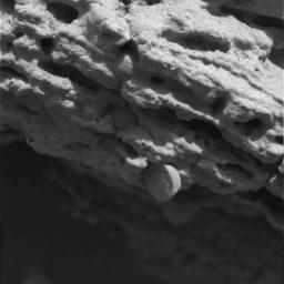
This sharp, close-up image taken by the microscopic imager on the Mars Exploration Rover Opportunity's instrument deployment device, or "arm," shows a rock target dubbed "Robert E," located on the rock outcrop at Meridiani Planum, Mars. Scientists are studying the spherule, or small sphere, in the center of the image that appears to be protruding from the rock formation. This image measures 3 centimeters (1.2 inches) across and was taken on the 15th day of Opportunity's journey (Feb. 8, 2004).


__________________


Signaler ce message à un modérateur | IP: Logguée
Temps en ligne : 8 Jours, 15 Heures, 44 Minutes, 21 Secondes en ligne

Old Post 10-02-2004 00:14
Cliquez ici pour voir le profil de Seth Cliquez ici pour lui envoyer un message privé  Trouver plus de messages de Seth Ajouter Seth à votre liste d'amis Editer/Effacer le Message Citer le message dans la réponse
 Seth  Rechercher tous les messages de ce membre Cliquez ici pour envoyer un message privé à cet utilisateur
Confirmé

Déconnecté

Niveau : 3
N° de Membre : 1512

Ancienneté : 100%
Participation : 2%
Inscription: 07 May 2002
Localisation:
Messages: 1390
Sujets Lancés : 70


http://photojournal.jpl.nasa.gov/jp...5239_modest.jpg
PIA05239.tif (1.05 MB): http://photojournal.jpl.nasa.gov/tiff/PIA05239.tif

Citation:
The round, shallow depression in this image resulted from history's first grinding of a rock on Mars. The rock abrasion tool on NASA's Spirit rover ground off the surface of a patch 45.5 millimeters (1.8 inches) in diameter on a rock called Adirondack. The hole is 2.65 millimeters (0.1 inch) deep, exposing fresh interior material of the rock for close inspection with the rover's microscopic imager and two spectrometers on the robotic arm. This image was taken by Spirit's panoramic camera, providing a quick visual check of the success of the grinding. The rock abrasion tools on both Mars Exploration Rovers were supplied by Honeybee Robotics, New York, N.Y.


__________________


Signaler ce message à un modérateur | IP: Logguée
Temps en ligne : 8 Jours, 15 Heures, 44 Minutes, 21 Secondes en ligne

Old Post 10-02-2004 00:15
Cliquez ici pour voir le profil de Seth Cliquez ici pour lui envoyer un message privé  Trouver plus de messages de Seth Ajouter Seth à votre liste d'amis Editer/Effacer le Message Citer le message dans la réponse
 Seth  Rechercher tous les messages de ce membre Cliquez ici pour envoyer un message privé à cet utilisateur
Confirmé

Déconnecté

Niveau : 3
N° de Membre : 1512

Ancienneté : 100%
Participation : 2%
Inscription: 07 May 2002
Localisation:
Messages: 1390
Sujets Lancés : 70


http://photojournal.jpl.nasa.gov/jp...5240_modest.jpg
PIA05240.tif (307.8 kB): http://photojournal.jpl.nasa.gov/tiff/PIA05240.tif

Citation:
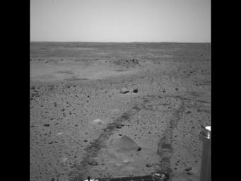
The Mars Exploration Rover Spirit drove itself 1 meter (3 feet) out of 6.4 meters (21 feet) at Gusev Crater, Mars, on Feb. 8, 2004, the 36th sol of its mission. This image shows the tracks it created in the martian soil as it drove straight ahead, then to the left. The rover also drove over Adirondack (seen in image bottom center), the bright rock that was targeted by Spirit's rock abrasion tool, on its way to a rock target called White Boat. This was the first test of the rover's autonomous system, which will be used many times in the days to come.


http://marsrovers.jpl.nasa.gov/gall...61P1635L0M1.jpg


__________________


Signaler ce message à un modérateur | IP: Logguée
Temps en ligne : 8 Jours, 15 Heures, 44 Minutes, 21 Secondes en ligne

Old Post 10-02-2004 00:17
Cliquez ici pour voir le profil de Seth Cliquez ici pour lui envoyer un message privé  Trouver plus de messages de Seth Ajouter Seth à votre liste d'amis Editer/Effacer le Message Citer le message dans la réponse
 Seth  Rechercher tous les messages de ce membre Cliquez ici pour envoyer un message privé à cet utilisateur
Confirmé

Déconnecté

Niveau : 3
N° de Membre : 1512

Ancienneté : 100%
Participation : 2%
Inscription: 07 May 2002
Localisation:
Messages: 1390
Sujets Lancés : 70


http://photojournal.jpl.nasa.gov/jp...5231_modest.jpg
PIA05231.tif (88.13 MB): http://photojournal.jpl.nasa.gov/tiff/PIA05231.tif

Citation:
A computer graphics model of the Opportunity lander and rover are super-imposed on top of the martian terrain where Opportunity landed.


http://photojournal.jpl.nasa.gov/fi...05231_label.jpg


__________________


Signaler ce message à un modérateur | IP: Logguée
Temps en ligne : 8 Jours, 15 Heures, 44 Minutes, 21 Secondes en ligne

Old Post 10-02-2004 01:51
Cliquez ici pour voir le profil de Seth Cliquez ici pour lui envoyer un message privé  Trouver plus de messages de Seth Ajouter Seth à votre liste d'amis Editer/Effacer le Message Citer le message dans la réponse
 Seth  Rechercher tous les messages de ce membre Cliquez ici pour envoyer un message privé à cet utilisateur
Confirmé

Déconnecté

Niveau : 3
N° de Membre : 1512

Ancienneté : 100%
Participation : 2%
Inscription: 07 May 2002
Localisation:
Messages: 1390
Sujets Lancés : 70


http://photojournal.jpl.nasa.gov/jp...5250_modest.jpg
PIA05250.tif (1.05 MB): http://photojournal.jpl.nasa.gov/tiff/PIA05250.tif

Citation:
Spirit took this front hazard-avoidance camera image on sol 37 (Feb. 9, 2004) after completing the longest drive ever made by a rover on another planet - 21.2 meters (69.6 feet). The wavy feature called a bedform is created when material is transported and deposited by some process - in this case wind. The team is interested in the fact that the crests of this and most other bedforms they've observed through orbital data and rover images are all parallel to each other, indicating uniform wind direction.


__________________


Signaler ce message à un modérateur | IP: Logguée
Temps en ligne : 8 Jours, 15 Heures, 44 Minutes, 21 Secondes en ligne

Old Post 10-02-2004 23:07
Cliquez ici pour voir le profil de Seth Cliquez ici pour lui envoyer un message privé  Trouver plus de messages de Seth Ajouter Seth à votre liste d'amis Editer/Effacer le Message Citer le message dans la réponse
Il est actuellement 12:27 (GMT) Poster un nouveau sujet    Poster une réponse   
Page(s) (49): [ <<   <   10   11   12   13   14   15   16   17   18   19   20   21   22   23   24   25   26   27   28   >   >> ]  Sujet précédent   Sujet suivant
Forum OXMO > Section Généraliste > Discussion Libre > Je vous parle en direct de Mars (Opportunity a atterri !)

Aller au Forum:
Notez ce sujet :


 Réponse Rapide
Titre: (Optionnel)
Message:

Convertir automatiquement les URLs Montrer la Signature
Afficher une version imprimable | Envoyer cette page par email | S'inscrire à ce sujet | Télécharger ce sujet
Règles du forum :
Créer de nouveaux sujets
Répondre aux messages
Attacher des fichiers
Editer vos messages
: not autorisé
: not autorisé
: not autorisé
: not autorisé
Le Code HTML est OFF
Le Code vB est ON
Les Smileys sont ONs
Le code [IMG] est ON
 
< Contactez-nous - Forum OXMO>

Uptime du serveur SQL : 2 jour(s) 12 heure(s) et 3 minute(s)
Page générée en 0.017574 secondes en exécutant 42 requêtes SQL.
Apache - Compression GZIP : Activée.