Accueil Foire Aux Questions Trouver d'autres membres Rechercher Utilisez le vBpad pour stocker des notes personnelles Ici, vous pouvez voir les sujets auxquels vous avez souscris, vos messages privés; et modifier vos informations personnelles et préférences. Statistiques du forum Enregistrez vous gratuitement ! Se déconnecter  
Forum OXMO Forum OXMO > Section Généraliste > Discussion Libre > [FUSION] [News] Cassini Mission


Aller au Forum:
Notez ce sujet :

Page(s) (2): [ <   1   2   ]   Sujet précédent   Sujet suivant
Auteur
Sujet Poster un nouveau sujet    Poster une réponse
 Seth  Rechercher tous les messages de ce membre Cliquez ici pour envoyer un message privé à cet utilisateur
Confirmé

Déconnecté

Niveau : 3
N° de Membre : 1512

Ancienneté : 100%
Participation : 2%
Inscription: 07 May 2002
Localisation:
Messages: 1390
Sujets Lancés : 70


Citation:
This is one of the first raw images returned by the European Space Agency's Huygens probe during its successful descent to Titan. It was taken at an altitude of 8 kilometers (about 5 miles) with a resolution of 20 meters (about 65 feet) per pixel. It shows what could be the landing site, with shorelines and boundaries between raised ground and flooded plains.

It was taken with the Descent Imager/Spectral Radiometer, one of two NASA instruments on the probe.

The Cassini-Huygens mission is a cooperative project of NASA, the European Space Agency and the Italian Space Agency. The Jet Propulsion Laboratory, a division of the California Institute of Technology in Pasadena, manages the Cassini-Huygens mission for NASA's Science Mission Directorate, Washington, D.C. The Cassini orbiter and its two onboard cameras were designed, developed and assembled at JPL. The Descent Imager/Spectral team is based at the University of Arizona, Tucson, Ariz.


__________________


Signaler ce message à un modérateur | IP: Logguée
Temps en ligne : 8 Jours, 15 Heures, 44 Minutes, 21 Secondes en ligne

Old Post 15-01-2005 01:51
Cliquez ici pour voir le profil de Seth Cliquez ici pour lui envoyer un message privé  Trouver plus de messages de Seth Ajouter Seth à votre liste d'amis Editer/Effacer le Message Citer le message dans la réponse
 Seth  Rechercher tous les messages de ce membre Cliquez ici pour envoyer un message privé à cet utilisateur
Confirmé

Déconnecté

Niveau : 3
N° de Membre : 1512

Ancienneté : 100%
Participation : 2%
Inscription: 07 May 2002
Localisation:
Messages: 1390
Sujets Lancés : 70


Citation:
This map of a portion of the surface of Saturn's moon Titan shows predictions for the areas that will be covered by selected combinations of images anticipated from the camera on the Huygens probe as it descends through Titan's atmosphere on Jan. 14, 2005. The map is made from data acquired by the visual and infrared mapping spectrometer aboard the Cassini orbiter during the orbiter's flyby of Titan in October 2004. Cassini released the Huygens probe in December 2004.

The octagons indicate anticipated fields of view of panoramic mosaics of images taken by Huygens' descent imager and spectral radiometer instrument as the probe reaches certain altitudes during its descent. This map shows the footprints for mosaics to be assembled from 36 individual images at each altitude, with the field of view cut off at 75 degrees from straight down although the actual images will extend all the way to the hazy horizon. Each mosaic made this way will be about 1,300 by 1,300 pixels.

The largest octagon (in red) is about 1,120 kilometers (696 miles) across and represents the field of view for the mosaic of images taken at an altitude of 150 kilometers (93 miles). From that height, individual pixels in the center of the image will be about 150 meters (492 feet) across, though haze between the ground and the camera at that height will likely degrade the resolution in those images. The progressively smaller octagons are the anticipated fields of view from altitudes of 90 kilometers (60 miles), 50 kilometers (30 miles) and 30 kilometers (19 miles). In all, the camera is expected to acquire panoramic mosaics at a total of 20 different altitudes from 150 kilometers (93 miles) down to about 3 kilometers (2 miles). The pixel size in the mosaic from 3 kilometers high will be about 3 meters (10 feet) across. In addition, the camera is expected to obtain individual images down to an altitude of about 200 meters (656 feet) with pixel size as small as 20 centimeters (8 inches).

The location of the anticipated landing site is based on modeling of Titan's winds, and the actual landing site will be different if the actual winds experienced by Huygens during descent differ from this model.

The Cassini-Huygens mission is a cooperative project of NASA, the European Space Agency and the Italian Space Agency. The Jet Propulsion Laboratory, a division of the California Institute of Technology in Pasadena, manages the Cassini-Huygens mission for NASA's Science Mission Directorate, Washington. The Cassini orbiter and its two onboard cameras were designed, developed and assembled at JPL. The visible and infrared mapping spectrometer team is based at the University of Arizona, Tucson.


__________________


Signaler ce message à un modérateur | IP: Logguée
Temps en ligne : 8 Jours, 15 Heures, 44 Minutes, 21 Secondes en ligne

Old Post 15-01-2005 01:52
Cliquez ici pour voir le profil de Seth Cliquez ici pour lui envoyer un message privé  Trouver plus de messages de Seth Ajouter Seth à votre liste d'amis Editer/Effacer le Message Citer le message dans la réponse
 Seth  Rechercher tous les messages de ce membre Cliquez ici pour envoyer un message privé à cet utilisateur
Confirmé

Déconnecté

Niveau : 3
N° de Membre : 1512

Ancienneté : 100%
Participation : 2%
Inscription: 07 May 2002
Localisation:
Messages: 1390
Sujets Lancés : 70


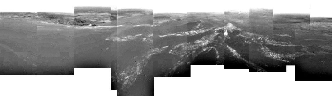
This composite was produced from images returned yesterday, January 14, 2005, by the European Space Agency's Huygens probe during its successful descent to land on Titan. It shows a full 360-degree view around Huygens. The left-hand side, behind Huygens, shows a boundary between light and dark areas. The white streaks seen near this boundary could be ground 'fog,' as they were not immediately visible from higher altitudes.

As the probe descended, it drifted over a plateau (center of image) and was heading towards its landing site in a dark area (right). From the drift of the probe, the wind speed has been estimated at around 6-7 kilometers (about 4 miles) per hour.

These images were taken from an altitude of about 8 kilometers (about 5 miles) with a resolution of about 20 meters (about 65 feet) per pixel. The images were taken by the Descent Imager/Spectral Radiometer, one of two NASA instruments on the probe.


__________________


Signaler ce message à un modérateur | IP: Logguée
Temps en ligne : 8 Jours, 15 Heures, 44 Minutes, 21 Secondes en ligne

Old Post 17-01-2005 14:03
Cliquez ici pour voir le profil de Seth Cliquez ici pour lui envoyer un message privé  Trouver plus de messages de Seth Ajouter Seth à votre liste d'amis Editer/Effacer le Message Citer le message dans la réponse
 Seth  Rechercher tous les messages de ce membre Cliquez ici pour envoyer un message privé à cet utilisateur
Confirmé

Déconnecté

Niveau : 3
N° de Membre : 1512

Ancienneté : 100%
Participation : 2%
Inscription: 07 May 2002
Localisation:
Messages: 1390
Sujets Lancés : 70


This image was returned yesterday, January 14, 2005, by the European Space Agency's Huygens probe during its successful descent to land on Titan. This is the colored view, following processing to add reflection spectra data, and gives a better indication of the actual color of the surface.

Initially thought to be rocks or ice blocks, they are more pebble-sized. The two rock-like objects just below the middle of the image are about 15 centimeters (about 6 inches) (left) and 4 centimeters (about 1.5 inches) (center) across respectively, at a distance of about 85 centimeters (about 33 inches) from Huygens. The surface is darker than originally expected, consisting of a mixture of water and hydrocarbon ice. There is also evidence of erosion at the base of these objects, indicating possible fluvial activity.

The image was taken with the Descent Imager/Spectral Radiometer, one of two NASA instruments on the probe.


__________________


Signaler ce message à un modérateur | IP: Logguée
Temps en ligne : 8 Jours, 15 Heures, 44 Minutes, 21 Secondes en ligne

Old Post 17-01-2005 14:04
Cliquez ici pour voir le profil de Seth Cliquez ici pour lui envoyer un message privé  Trouver plus de messages de Seth Ajouter Seth à votre liste d'amis Editer/Effacer le Message Citer le message dans la réponse
 Seth  Rechercher tous les messages de ce membre Cliquez ici pour envoyer un message privé à cet utilisateur
Confirmé

Déconnecté

Niveau : 3
N° de Membre : 1512

Ancienneté : 100%
Participation : 2%
Inscription: 07 May 2002
Localisation:
Messages: 1390
Sujets Lancés : 70


This composite was produced from images returned yesterday, January 14, 2005, by the European Space Agency's Huygens probe during its successful descent to land on Titan. It shows the boundary between the lighter-colored uplifted terrain, marked with what appear to be drainage channels, and darker lower areas.

These images were taken from an altitude of about 8 kilometers (about 5 miles) and a resolution of about 20 meters (about 65 feet) per pixel. The images were taken by the Descent Imager/Spectral Radiometer, one of two NASA instruments on the probe.


__________________


Signaler ce message à un modérateur | IP: Logguée
Temps en ligne : 8 Jours, 15 Heures, 44 Minutes, 21 Secondes en ligne

Old Post 17-01-2005 14:05
Cliquez ici pour voir le profil de Seth Cliquez ici pour lui envoyer un message privé  Trouver plus de messages de Seth Ajouter Seth à votre liste d'amis Editer/Effacer le Message Citer le message dans la réponse
 fleming  Rechercher tous les messages de ce membre Cliquez ici pour envoyer un message privé à cet utilisateur
Super Moderateur

Déconnecté

Niveau : 5
N° de Membre : 7849

Ancienneté : 97%
Participation : 23%
Inscription: 06 Jan 2003
Localisation: Augustoritum
Messages: 19502
Sujets Lancés : 319

zappez sur la 5 !

pour ceux que ça intéresse, la mission Cassini-Huygens est actuellement le sujet du débat de l'excellent émission d'Yves Calvi "C dans l'air" sur la 5ème... Zappez vite , ça dure 1 H jusqu'à 18H50 environ... et c'est passionant !


__________________

Les tôles ondulées mais les vaches aussi.


Signaler ce message à un modérateur | IP: Logguée
Temps en ligne : 95 Jours, 0 Heure, 24 Minutes, 20 Secondes en ligne

Old Post 21-01-2005 18:08
Cliquez ici pour voir le profil de fleming Cliquez ici pour lui envoyer un message privé  Trouver plus de messages de fleming Ajouter fleming à votre liste d'amis Editer/Effacer le Message Citer le message dans la réponse
Il est actuellement 09:01 (GMT) Poster un nouveau sujet    Poster une réponse   
Page(s) (2): [ <   1   2   ]  Sujet précédent   Sujet suivant
Forum OXMO > Section Généraliste > Discussion Libre > [FUSION] [News] Cassini Mission

Aller au Forum:
Notez ce sujet :


 Réponse Rapide
Titre: (Optionnel)
Message:

Convertir automatiquement les URLs Montrer la Signature
Afficher une version imprimable | Envoyer cette page par email | S'inscrire à ce sujet | Télécharger ce sujet
Règles du forum :
Créer de nouveaux sujets
Répondre aux messages
Attacher des fichiers
Editer vos messages
: not autorisé
: not autorisé
: not autorisé
: not autorisé
Le Code HTML est OFF
Le Code vB est ON
Les Smileys sont ONs
Le code [IMG] est ON
 
< Contactez-nous - Forum OXMO>

Uptime du serveur SQL : 3 jour(s) 8 heure(s) et 37 minute(s)
Page générée en 0.018512 secondes en exécutant 34 requêtes SQL.
Apache - Compression GZIP : Activée.