ACCUEIL F.A.Q. S'INSCRIRE CONNEXION
Forum OXMO > Section Généraliste > Discussion Libre >

Je vous parle en direct de Mars (Opportunity a atterri !)


Aller au Forum:
Notez ce sujet :

Page(s) (49): [ <<   <   14   15   16   17   18   19   20   21   22   23   24   25   26   27   28   29   30   31   32   >   >> ]   Sujet précédent   Sujet suivant
Auteur
Sujet    Tout développer | Tout contracter NOUVEAU SUJET    RÉPONDRE
Réduire ce message Membre Seth
Confirmé

Niveau : 3
N° de Membre : 1512

Ancienneté : 100%
Participation : 57%
Inscription: 07 May 2002
Localisation:
Messages: 1390
Sujets Lancés : 70


https://photojournal.jpl.nasa.gov/j...5337_modest.jpg
PIA05337.tif (1.05 MB): NASA SciencePhotojournal - NASA ScienceWelcome to Photojournal's new web presence on Science@NASA. Our new site contains all the same great images, animations, and videos as our previous site.

Citation
A view from the front hazard avoidance camera of NASA's Spirit rover on its 47th sol shows a trench excavated by the rover's left front wheel within the "Laguna Hollow" area. The trench, dubbed "Road Cut," is 7 centimeters (3 inches) deep. The soil at this location is more cohesive than the material where Spirit's twin, Opportunity, dug its first trench at Meridiani. Spirit made 11 back-and-forth passes to dig this trench, and still did not produce as deep a hole as Opportunity dug in 6 passes. Scientists and engineers plan to begin up-close inspection of the soil in this trench on sol 48 by placing the microscopic imager on the floor and the walls before conducting Moessbauer and alpha particle x-ray spectrometer readings on some of the same points.


__________________


Signaler ce message à un modérateur | IP: Logguée
Temps en ligne : 8 Jours, 15 Heures, 44 Minutes, 21 Secondes en ligne

Ancien message 20-02-2004 22:50
PROFIL PM  RECH. AMIS ÉDITER CITER
Réduire ce message Membre Seth
Confirmé

Niveau : 3
N° de Membre : 1512

Ancienneté : 100%
Participation : 57%
Inscription: 07 May 2002
Localisation:
Messages: 1390
Sujets Lancés : 70


https://photojournal.jpl.nasa.gov/j...5338_modest.jpg
PIA05338.tif (3.428 MB): NASA SciencePhotojournal - NASA ScienceWelcome to Photojournal's new web presence on Science@NASA. Our new site contains all the same great images, animations, and videos as our previous site.


https://photojournal.jpl.nasa.gov/f...placement_1.jpg

https://photojournal.jpl.nasa.gov/f...placement_2.jpg

Citation
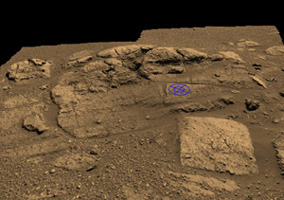
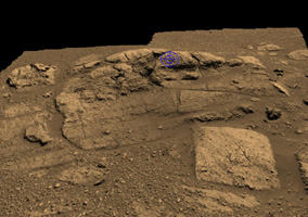
These two graphics are planning tools used by Mars Exploration Rover engineers to plot and scheme the perfect location to place the rock abrasion tool on the rock collection dubbed "El Capitan" near Opportunity's landing site. "El Capitan" is located within a larger outcrop nicknamed "Opportunity Ledge."

The rover visualization team from NASA Ames Research Center, Moffett Field, Calif., initiated the graphics by putting two panoramic camera images of the "El Capitan" area into their three-dimensional model. The rock abrasion tool team from Honeybee Robotics then used the visualization tool to help target and orient their instrument on the safest and most scientifically interesting locations. The blue circle represents one of two current targets of interest, chosen because of its size, lack of dust, and most of all its distinct and intriguing geologic features. To see the second target location, see the image titled "Plotting and Scheming."

The rock abrasion tool is sensitive to the shape and texture of a rock, and must safely sit within the "footprint" indicated by the blue circles. The rock area must be large enough to fit the contact sensor and grounding mechanism within the area of the outer blue circle, and the rock must be smooth enough to get an even grind within the abrasion area of the inner blue circle. If the rock abrasion tool were not grounded by its support mechanism or if the surface were uneven, it could "run away" from its target. The rock abrasion tool is location on the rover's instrument deployment device, or arm.

Over the next few martian days, or sols, the rover team will use these and newer, similar graphics created with more recent, higher-resolution panoramic camera images and super-spectral data from the miniature thermal emission spectrometer. These data will be used to pick the best spots to apply the rock abrasion tool on two very distinct areas of "El Capitan." The upper and lower portions of "El Capitan" have different textures, and both areas should provide distinct and unique clues about the history of Mars. The rock abrasion tool will also enter the target areas from different perspectives, creating unique views simply by the way they grind into the different areas of the rocks. For the current upper target (Fig. 1), the rock abrasion tool would go into the rock as if from the side of a layered cake, while at the bottom target (Fig. 2), the instrument would enter from above as if going down the middle of a cake.

"El Capitan" was named after a mountain in Texas, but on Mars, it is about 10 centimeters (4 inches) high. Scientists are eager to use the rock abrasion tool to peer deeper into the history of the formation of "El Capitan," and the team will spend multiple sols taking pre- and post-measurements of the rock targets. Opportunity will spend one sol moving inbetween target locations.


__________________


Signaler ce message à un modérateur | IP: Logguée
Temps en ligne : 8 Jours, 15 Heures, 44 Minutes, 21 Secondes en ligne

Ancien message 21-02-2004 01:22
PROFIL PM  RECH. AMIS ÉDITER CITER
Réduire ce message Membre alex_le_vex
Expert

Niveau : 3
N° de Membre : 11374

Ancienneté : 96%
Participation : 60%
Inscription: 30 Mar 2003
Localisation: Dans ton cul au fond à droite
Age: 36
Messages: 1617
Sujets Lancés : 71


__________________

Alex - Rahaiz


Signaler ce message à un modérateur | IP: Logguée
Temps en ligne : 6 Jours, 21 Heures, 12 Minutes, 43 Secondes en ligne

Ancien message 21-02-2004 22:26
PROFIL PM  RECH. AMIS ÉDITER CITER
Réduire ce message Membre Seth
Confirmé

Niveau : 3
N° de Membre : 1512

Ancienneté : 100%
Participation : 57%
Inscription: 07 May 2002
Localisation:
Messages: 1390
Sujets Lancés : 70

Message écrit par alex_le_vex, le 22-02-2004 à 07:26


Nice one alex_le_vex


__________________


Signaler ce message à un modérateur | IP: Logguée
Temps en ligne : 8 Jours, 15 Heures, 44 Minutes, 21 Secondes en ligne

Ancien message 21-02-2004 22:37
PROFIL PM  RECH. AMIS ÉDITER CITER
Réduire ce message Membre Solacin
Guru

Niveau : 5
N° de Membre : 11117

Ancienneté : 96%
Participation : 89%
Inscription: 23 Mar 2003
Localisation: 974
Age: 52
Messages: 8254
Sujets Lancés : 28

HAHAHAHA


__________________


Signaler ce message à un modérateur | IP: Logguée
Temps en ligne : 25 Jours, 5 Heures, 22 Minutes, 48 Secondes en ligne

Ancien message 24-02-2004 12:07
PROFIL PM  RECH. AMIS ÉDITER CITER
Réduire ce message Membre Seth
Confirmé

Niveau : 3
N° de Membre : 1512

Ancienneté : 100%
Participation : 57%
Inscription: 07 May 2002
Localisation:
Messages: 1390
Sujets Lancés : 70


https://photojournal.jpl.nasa.gov/j...5441_modest.jpg
PIA05441.tif (5.745 MB): NASA SciencePhotojournal - NASA ScienceWelcome to Photojournal's new web presence on Science@NASA. Our new site contains all the same great images, animations, and videos as our previous site.

Citation
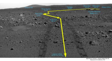
This image is a traverse map, illustrating Spirit's path over the last 45 sols. When the rover reached the point called "Laguna Hollow," it had driven 131 meters (430 feet) from Columbia Memorial Station. The rover heading is 45 degrees to the northeast. On the horizon behind the lander looms the landmark informally named "Grissom Hill." Over the relatively flat traverse, Spirit has made observations of rocks such as "Adirondack" and utilized the tools on its arm to investigate soil in several locations. Spirit stayed at "Laguna Hollow" for 3 sols, dug a trench and observed the floor and wall of it with three of the instruments on its arm: the Moessbauer spectrometer, the alpha particle X-ray spectrometer and the microscopic imager. Spirit is about halfway to the edge of the crater dubbed "Bonneville".


__________________


Signaler ce message à un modérateur | IP: Logguée
Temps en ligne : 8 Jours, 15 Heures, 44 Minutes, 21 Secondes en ligne

Ancien message 24-02-2004 22:21
PROFIL PM  RECH. AMIS ÉDITER CITER
Réduire ce message Membre Seth
Confirmé

Niveau : 3
N° de Membre : 1512

Ancienneté : 100%
Participation : 57%
Inscription: 07 May 2002
Localisation:
Messages: 1390
Sujets Lancés : 70


https://photojournal.jpl.nasa.gov/j...5442_modest.jpg
PIA05442.tif (262.6 kB): NASA SciencePhotojournal - NASA ScienceWelcome to Photojournal's new web presence on Science@NASA. Our new site contains all the same great images, animations, and videos as our previous site.

Citation
NASA's Mars Exploration Rover Opportunity casts a shadow over the El Capitan area that the rover is examining with tools on its robotic arm. Opportunity took this image with its front hazard-avoidance camera on Feb. 23, 2004, during the rover's 29th martian day, or sol. Opportunity used its rock abrasion tool to grind a small hole into Opportunity Ledge later on sol 29 to prepare for using the other tools on its arm to analyze the freshly exposed rock during subsequent sols.


__________________


Signaler ce message à un modérateur | IP: Logguée
Temps en ligne : 8 Jours, 15 Heures, 44 Minutes, 21 Secondes en ligne

Ancien message 24-02-2004 22:23
PROFIL PM  RECH. AMIS ÉDITER CITER
Réduire ce message Membre Seth
Confirmé

Niveau : 3
N° de Membre : 1512

Ancienneté : 100%
Participation : 57%
Inscription: 07 May 2002
Localisation:
Messages: 1390
Sujets Lancés : 70


Animated GIF (5.208 megabytes): https://photojournal.jpl.nasa.gov/archive/PIA05344.gif

Citation
This animation shows the Mars Exploration Rover Spirit digging a trench in the fine-grained soil lining the bottom of the shallow depression dubbed "Laguna Hollow." The trench is 7 centimeters (3 inches) deep and was created after the rover dragged one of its wheels back and forth across the surface 11 times. The whole operation lasted about two hours. A similar trench dug on the other side of Mars by Spirit's twin, Opportunity, is 10 centimeters deep (4 inches) and took only six sweeps to complete, indicating that the soil there is more loosely packed.
Spirit excavated its trench by repeating two basic steps: first, it spun its left front wheel in reverse to dig; second, it turned left and spun the same wheel in the forward direction. To widen the trench, each pass back and forth began a little farther to the right. By the end, the rover had swiveled 40 degrees.

Spirit is traveling toward a large crater nicknamed "Bonneville." It has stopped along the way at "Laguna Hollow" to take a closer look at the fine sediments contained there. The movie consists of images taken by Spirit's front hazard-avoidance camera.


__________________


Signaler ce message à un modérateur | IP: Logguée
Temps en ligne : 8 Jours, 15 Heures, 44 Minutes, 21 Secondes en ligne

Ancien message 24-02-2004 22:24
PROFIL PM  RECH. AMIS ÉDITER CITER
Réduire ce message Membre Seth
Confirmé

Niveau : 3
N° de Membre : 1512

Ancienneté : 100%
Participation : 57%
Inscription: 07 May 2002
Localisation:
Messages: 1390
Sujets Lancés : 70


Animated GIF (1.393 megabytes): https://photojournal.jpl.nasa.gov/archive/PIA05345.gif

Citation
This movie was compiled from a series of 10 images taken by the Mars Exploration Rover Spirit's front hazard-avoidance camera. The images were taken at 10-minute intervals on February 21, 2004 at the trenching site dubbed "Laguna Hollow." Between the first and second images, the head of the panoramic camera mast assembly can be seen preparing to take miniature thermal emission spectrometer measurements. The spectrometer focused on a designated spot approximately 3 meters (9.8 feet) from the center of rover for 90 minutes, measuring the cooling effect caused by sunlight turning to shade. By observing the rate at which the material at this site cooled, scientists will be able to characterize its physical properties. This site provided a unique opportunity to compare the subsurface material exposed by the trenching activity with the surface material affected by the shadow experiment.


__________________


Signaler ce message à un modérateur | IP: Logguée
Temps en ligne : 8 Jours, 15 Heures, 44 Minutes, 21 Secondes en ligne

Ancien message 24-02-2004 22:25
PROFIL PM  RECH. AMIS ÉDITER CITER
Réduire ce message Membre Solacin
Guru

Niveau : 5
N° de Membre : 11117

Ancienneté : 96%
Participation : 89%
Inscription: 23 Mar 2003
Localisation: 974
Age: 52
Messages: 8254
Sujets Lancés : 28

Cooooooooooool, encore des infos ..... pour l'anim avec la roue, ils vont refaire une mini-tranchée pour en analyser le contenu à nouveau ?


__________________


Signaler ce message à un modérateur | IP: Logguée
Temps en ligne : 25 Jours, 5 Heures, 22 Minutes, 48 Secondes en ligne

Ancien message 25-02-2004 05:44
PROFIL PM  RECH. AMIS ÉDITER CITER
Réduire ce message Membre Seth
Confirmé

Niveau : 3
N° de Membre : 1512

Ancienneté : 100%
Participation : 57%
Inscription: 07 May 2002
Localisation:
Messages: 1390
Sujets Lancés : 70

Je pense que c'est une nouvelle tranchee.


__________________


Signaler ce message à un modérateur | IP: Logguée
Temps en ligne : 8 Jours, 15 Heures, 44 Minutes, 21 Secondes en ligne

Ancien message 25-02-2004 05:52
PROFIL PM  RECH. AMIS ÉDITER CITER
Réduire ce message Membre Seth
Confirmé

Niveau : 3
N° de Membre : 1512

Ancienneté : 100%
Participation : 57%
Inscription: 07 May 2002
Localisation:
Messages: 1390
Sujets Lancés : 70


https://photojournal.jpl.nasa.gov/j...5447_modest.jpg
PIA05447.tif (1.286 MB): NASA SciencePhotojournal - NASA ScienceWelcome to Photojournal's new web presence on Science@NASA. Our new site contains all the same great images, animations, and videos as our previous site.
PIA05447.jpg (325.8 kB): https://photojournal.jpl.nasa.gov/jpeg/PIA05447.jpg

Citation
26 February 2004
This Mars Global Surveyor (MGS) Mars Orbiter Camera (MOC) image shows two craters and a rough-textured surface in Icaria Planum near 44.5°S, 109.8°W. Both craters have been buried by a thin mantle of material that eroded to form a rough texture. The ejecta pattern from the smaller of the two craters is still apparent through this mantle. While this is a southern mid-latitude surface, similar textures and thinly-buried craters are common at northern mid-latitudes, as well. Sunlight illuminates the scene from the upper left; the picture covers an area 3 km (1.9 mi) wide.


__________________


Signaler ce message à un modérateur | IP: Logguée
Temps en ligne : 8 Jours, 15 Heures, 44 Minutes, 21 Secondes en ligne

Ancien message 27-02-2004 00:41
PROFIL PM  RECH. AMIS ÉDITER CITER
Réduire ce message Membre Seth
Confirmé

Niveau : 3
N° de Membre : 1512

Ancienneté : 100%
Participation : 57%
Inscription: 07 May 2002
Localisation:
Messages: 1390
Sujets Lancés : 70


https://photojournal.jpl.nasa.gov/j...5448_modest.jpg
PIA05448.tif (74.79 MB) NASA SciencePhotojournal - NASA ScienceWelcome to Photojournal's new web presence on Science@NASA. Our new site contains all the same great images, animations, and videos as our previous site.
JPEG: PIA05448.jpg (1.508 MB) https://photojournal.jpl.nasa.gov/jpeg/PIA05448.jpg

Citation
This map shows the Mars Exploration Rover Spirit's travels since arriving on the red planet Jan. 3, 2004 PST. Spirit is on its way to a large crater nicknamed "Bonneville." On the 52nd day, or sol, of its mission (Feb. 25, 2004), it stopped off at a region nicknamed "Middle Ground" to investigate rocks and soil. The rover is facing northeast and is 98 meters (322 feet) away from the rim of "Bonneville." Data within the yellow box represent a digital map made of images taken by the rover's panoramic and navigation cameras. Data outside this box are a composite of images from the rover's descent image motion estimation system camera and NASA's orbiter Mars Global Surveyor.


__________________


Signaler ce message à un modérateur | IP: Logguée
Temps en ligne : 8 Jours, 15 Heures, 44 Minutes, 21 Secondes en ligne

Ancien message 27-02-2004 00:43
PROFIL PM  RECH. AMIS ÉDITER CITER
Réduire ce message Membre Seth
Confirmé

Niveau : 3
N° de Membre : 1512

Ancienneté : 100%
Participation : 57%
Inscription: 07 May 2002
Localisation:
Messages: 1390
Sujets Lancés : 70


https://photojournal.jpl.nasa.gov/j...5449_modest.jpg
PIA05449.tif (6.95 MB) NASA SciencePhotojournal - NASA ScienceWelcome to Photojournal's new web presence on Science@NASA. Our new site contains all the same great images, animations, and videos as our previous site.
JPEG: PIA05449.jpg (845.4 kB) https://photojournal.jpl.nasa.gov/jpeg/PIA05449.jpg

Citation
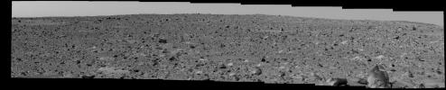
This image shows the Mars Exploration Rover Spirit's view of the rocky terrain that lies between it and its intended target, the large crater dubbed "Bonneville." The landscape here is roughly two times as bumpy and more difficult to traverse than that crossed so far. Spirit has currently stopped to examine the soil and rocks at a region nicknamed "Middle Ground." The rover is 98 meters (322 feet) away from "Bonneville" and facing northeast. The large rock called "Humphries" can be seen in the lower right corner. The image was taken on the 53rd martian day, or sol, of Spirit's mission by the rover's panoramic camera.


__________________


Signaler ce message à un modérateur | IP: Logguée
Temps en ligne : 8 Jours, 15 Heures, 44 Minutes, 21 Secondes en ligne

Ancien message 27-02-2004 00:45
PROFIL PM  RECH. AMIS ÉDITER CITER
Réduire ce message Membre Seth
Confirmé

Niveau : 3
N° de Membre : 1512

Ancienneté : 100%
Participation : 57%
Inscription: 07 May 2002
Localisation:
Messages: 1390
Sujets Lancés : 70


https://photojournal.jpl.nasa.gov/j...5450_modest.jpg
PIA05450.tif (7.534 MB) NASA SciencePhotojournal - NASA ScienceWelcome to Photojournal's new web presence on Science@NASA. Our new site contains all the same great images, animations, and videos as our previous site.

Citation
This image shows the path the Mars Exploration Rover Spirit has traveled since leaving its lander 53 martian days, or sols, ago. "Laguna Hollow," the shallow depression where Spirit dug a trench, can be seen to the right of center. Spirit stayed at "Laguna Hollow" for 3 sols, investigating the fine-grained soil contained there and the trench it dug with one of its wheels. The rover is headed northeast toward a large crater nicknamed "Bonneville." This panoramic camera image was taken from the rover's new location, a region dubbed "Middle Ground" located 98 meters (322 feet) away from "Bonneville".


__________________


Signaler ce message à un modérateur | IP: Logguée
Temps en ligne : 8 Jours, 15 Heures, 44 Minutes, 21 Secondes en ligne

Ancien message 27-02-2004 00:46
PROFIL PM  RECH. AMIS ÉDITER CITER
Il est actuellement 21:31 (GMT) NOUVEAU SUJET    RÉPONDRE   
Page(s) (49): [ <<   <   14   15   16   17   18   19   20   21   22   23   24   25   26   27   28   29   30   31   32   >   >> ]  Sujet précédent   Sujet suivant
Forum OXMO > Section Généraliste > Discussion Libre > Je vous parle en direct de Mars (Opportunity a atterri !)

Aller au Forum:
Notez ce sujet :


 Réponse Rapide
Titre: (Optionnel)
Message:

Convertir automatiquement les URLs Montrer la Signature
Afficher une version imprimable | Chercher dans ce sujet | Envoyer cette page par email | S'inscrire à ce sujet | Télécharger ce sujet
Règles du forum :
Créer de nouveaux sujets
Répondre aux messages
Attacher des fichiers
Editer vos messages
: not autorisé
: not autorisé
: not autorisé
: not autorisé
Le Code HTML est OFF
Le BBCode est ON
Les Smileys sont ONs
Le code [IMG] est ON
< Contactez-nous - Forum OXMO - Link Station>

Uptime du serveur SQL : 11 jour(s) 13 heure(s) et 8 minute(s)
Page générée en 0.058541 secondes en exécutant 49 requêtes SQL.
Apache - Compression GZIP : Activée.