Accueil Foire Aux Questions Trouver d'autres membres Rechercher Utilisez le vBpad pour stocker des notes personnelles Ici, vous pouvez voir les sujets auxquels vous avez souscris, vos messages privés; et modifier vos informations personnelles et préférences. Statistiques du forum Enregistrez vous gratuitement ! Se déconnecter  
Forum OXMO Forum OXMO > Section Généraliste > Discussion Libre > Je vous parle en direct de Mars (Opportunity a atterri !)


Aller au Forum:
Notez ce sujet :

Page(s) (49): [ <<   <   17   18   19   20   21   22   23   24   25   26   27   28   29   30   31   32   33   34   35   >   >> ]   Sujet précédent   Sujet suivant
Auteur
Sujet Poster un nouveau sujet    Poster une réponse
 Solacin  Rechercher tous les messages de ce membre Cliquez ici pour envoyer un message privé à cet utilisateur
Guru

Déconnecté

Niveau : 5
N° de Membre : 11117

Ancienneté : 96%
Participation : 10%
Inscription: 23 Mar 2003
Localisation: 974
Age: 52
Messages: 8253
Sujets Lancés : 28

Citation:

WASHINGTON (AFP) - L'eau a coulé en abondance sur Mars et des conditions favorables à la vie ont pu y exister, a annoncé mardi la Nasa en fondant ses conclusions sur les explorations menées par l'un de ses robots actuellement sur la planète rouge.

"C'est le genre d'endroit qui aurait pu permettre la vie, cela ne prouve pas que la vie y a été présente", a déclaré le responsable scientifique de la mission Mars Exploration Rover, Steve Squyres, après avoir annoncé que "l'eau a un jour coulé entre ces rochers" où évolue le robot Opportunity.


agrandir la photo
"Opportunity s'est posé dans une région de Mars où l'eau a un jour gorgé la surface, cette zone aurait été habitable", avait auparavant révélé Ed Weiler, l'administrateur adjoint de la Nasa pour la science spatiale.

En coulant à travers les roches de cette zone, l'eau "a changé leur texture et leur composition, nous avons pu détecter les indices laissés par la présence d'eau et cela nous permet d'en tirer cette conclusion", a poursuivi M. Squyres lors d'une conférence de presse au siège de la Nasa à Washington.

Les chercheurs tirent leurs conclusions de la composition actuelle des roches, qui contiennent notamment des sulfates et d'autres minéraux se formant en présence d'eau, ainsi que de la forme de certains rochers contenant des cavités où se sont formés certains cristaux.

Le robot a trouvé "une quantité impressionnante de sels" à la fois à la surface d'une roche et à l'intérieur de cette roche, a expliqué Benton Clark, membre de l'équipe scientifique de la mission. "La seule façon pour une telle quantité de sels de se former est de se dissoudre dans l'eau avant que l'eau ne s'évapore", a-t-il ajouté.

Les conclusions de la Nasa sont fondées sur l'analyse d'un substrat rocheux exposé, situé à l'intérieur d'un petit cratère, juste à côté du point de chute du robot Opportunity, dans une région appelée Meridiani Planum.

Le robot a consacré l'essentiel des trois dernières semaines à analyser cette roche, que les scientifiques ont appelée El Capitan. Les mesures reçues sur Terre montrent une forte concentration de soufre, détectée grâce au spectromètre à rayons-X qui équipe le robot.

"La forme chimique de ce soufre paraît être du magnésium, du fer et d'autres sels de sulfate", a précisé M. Clark, de la firme Lockheed Martin Space Systems à Denver (Colorado) qui participe à la mission. "Des éléments pouvant former du chlorure ou même des sels de bromure ont aussi été détectés", a-t-il ajouté.

D'autre part, l'analyse de l'apparence de cette roche fournit trois éléments indiquant la présence passée d'eau, a expliqué le géologue John Grotzinger, du Massachusetts Institute of Technology à Cambridge, près de Boston: "des indentations appelées druses, de petites sphères et une stratification oblique".

La Nasa a lancé cette mission pour découvrir "si au moins une partie de Mars a connu un environnement humide de longue durée qui aurait pu être hospitalier à la vie. Aujourd'hui nous avons des éléments pour fournir une réponse passionnante: oui", a de son côté déclaré James Garvin, responsable scientifique à la Nasa pour l'exploration de Mars et de la Lune.

Opportunity s'est posé sur Mars le 24 janvier, précédé par son jumeau, Spirit, arrivé le 3 janvier dans le cratère Gusev. Ils avaient été lancés à bord de sondes en juin et juillet 2003, de Cap Canaveral (Floride).

La mission des deux robots doit se poursuivre jusqu'à la fin avril. D'un coût de 820 millions de dollars, elle mobilise environ 300 scientifiques et techniciens. Son centre de contrôle est situé au Jet Propulsion Laboratory de la Nasa à Pasadena (Californie, ouest).


Là, je crois que c'est clair !!!


__________________


Signaler ce message à un modérateur | IP: Logguée
Temps en ligne : 25 Jours, 5 Heures, 18 Minutes, 53 Secondes en ligne

Old Post 03-03-2004 10:22
Cliquez ici pour voir le profil de Solacin Cliquez ici pour lui envoyer un message privé  Trouver plus de messages de Solacin Ajouter Solacin à votre liste d'amis       Editer/Effacer le Message Citer le message dans la réponse
 Seth  Rechercher tous les messages de ce membre Cliquez ici pour envoyer un message privé à cet utilisateur
Confirmé

Déconnecté

Niveau : 3
N° de Membre : 1512

Ancienneté : 100%
Participation : 2%
Inscription: 07 May 2002
Localisation:
Messages: 1390
Sujets Lancés : 70


PIA05494.tif (65.83 kB) http://photojournal.jpl.nasa.gov/tiff/PIA05494.tif

Citation:
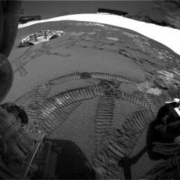
This rear hazard-avoidance camera image taken by the Mars Exploration Rover Opportunity on the 37th martian day, or sol, of its mission (March 2, 2004) shows the tracks left by the rover during its latest "dance," or series of maneuvers, around the rock outcrop near its landing site. Note the view of the lander to the far left and the light-colored outcrop below the horizon. The rear solar panels, located above the rear hazard-avoidance cameras, are captured in the uppermost part of the image.
Since driving off the lander, Opportunity has traveled along the entire outcrop, trenched, and completed a U-turn to revisit scientifically rich spots. Two of these spots are the rock regions dubbed "El Capitan" and "Last Chance." Scientists have used the instruments on the rover's arm to conclude that this area of Mars was once soaked in water for extended amounts of time, possibly providing an environment favorable for life.


Signaler ce message à un modérateur | IP: Logguée
Temps en ligne : 8 Jours, 15 Heures, 44 Minutes, 21 Secondes en ligne

Old Post 04-03-2004 01:20
Cliquez ici pour voir le profil de Seth Cliquez ici pour lui envoyer un message privé  Trouver plus de messages de Seth Ajouter Seth à votre liste d'amis Editer/Effacer le Message Citer le message dans la réponse
 Seth  Rechercher tous les messages de ce membre Cliquez ici pour envoyer un message privé à cet utilisateur
Confirmé

Déconnecté

Niveau : 3
N° de Membre : 1512

Ancienneté : 100%
Participation : 2%
Inscription: 07 May 2002
Localisation:
Messages: 1390
Sujets Lancés : 70


http://photojournal.jpl.nasa.gov/jp...5495_modest.jpg
PIA05495.tif (1.05 MB) http://photojournal.jpl.nasa.gov/tiff/PIA05495.tif

Citation:
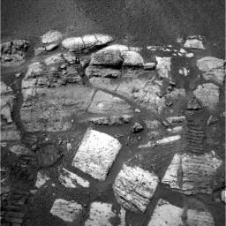
This navigation camera image taken by the Mars Exploration Rover Opportunity on the 36 martian day, or sol, of its mission (March 1, 2004) shows the layered rocks of the "El Capitan" area near the rover's landing site at Meridani Planum, Mars. Visible on two of the rocks are the holes drilled by the rover, which provided scientists with a window to this part of the red planet's water-soaked past.
Scientists used the rover's microscopic imager and two spectrometers to look at the details of the freshly exposed, clean surfaces created by the rover's rock abrasion tool. Seeing beyond the veil of dust and coatings on the surface of the rock, scientists obtained the best views of the chemical composition of the areas. These data indicated that the rocks are made up of types of sulfate that could have only been created by interaction between water and martian rock.

The chemical make-up of the two holes is slightly different, giving scientists an inkling into the geologic history of this area. This history may help to explain the origin of the granular hematite found around the small crater cradling Opportunity and the "El Capitan" rock region.

The sulfates and the other chemicals found in the rocks at this location on Mars also occur on Earth, but only rarely. In places like Rio Tinto, Spain, similar minerals are forming today, and microorganisms live and thrive there.

Analyzing these two clean surfaces created by the rock abrasion tool proves that Mars had interactions between water and rock over extended amounts of time. Life on Earth sustained by extended interaction between water and the environment. The fact that scientists have now found evidence of a similar relationship between water and rock and Mars does not necessarily mean that life did develop on Mars, but it does bring the possibility one step closer to reality.

Opportunity's wheel tracks can be seen at the bottom left and right sides of this image. The tracks extend to the center of the image, indicating where Opportunity sat when it analyzed the rocks with the instruments on its robotic arm.


Signaler ce message à un modérateur | IP: Logguée
Temps en ligne : 8 Jours, 15 Heures, 44 Minutes, 21 Secondes en ligne

Old Post 04-03-2004 01:21
Cliquez ici pour voir le profil de Seth Cliquez ici pour lui envoyer un message privé  Trouver plus de messages de Seth Ajouter Seth à votre liste d'amis Editer/Effacer le Message Citer le message dans la réponse
 Solacin  Rechercher tous les messages de ce membre Cliquez ici pour envoyer un message privé à cet utilisateur
Guru

Déconnecté

Niveau : 5
N° de Membre : 11117

Ancienneté : 96%
Participation : 10%
Inscription: 23 Mar 2003
Localisation: 974
Age: 52
Messages: 8253
Sujets Lancés : 28

Toujours un peu de reserve de la part de la NASA (compréhensible d'ailleurs), car ils précisent bien que les conditions apparaissaient favorables pour le développement d'une forme de vie sur Mars, mais que ce n'est pas forcément le cas ........ allez, encore un p'tit effort et ils vont bien finir par trouver des micro-organismes pour confirmer tout ça


__________________


Signaler ce message à un modérateur | IP: Logguée
Temps en ligne : 25 Jours, 5 Heures, 18 Minutes, 53 Secondes en ligne

Old Post 04-03-2004 05:34
Cliquez ici pour voir le profil de Solacin Cliquez ici pour lui envoyer un message privé  Trouver plus de messages de Solacin Ajouter Solacin à votre liste d'amis       Editer/Effacer le Message Citer le message dans la réponse
 Seth  Rechercher tous les messages de ce membre Cliquez ici pour envoyer un message privé à cet utilisateur
Confirmé

Déconnecté

Niveau : 3
N° de Membre : 1512

Ancienneté : 100%
Participation : 2%
Inscription: 07 May 2002
Localisation:
Messages: 1390
Sujets Lancés : 70


http://photojournal.jpl.nasa.gov/jp...5497_modest.jpg
PIA05497.tif (988.2 kB) http://photojournal.jpl.nasa.gov/tiff/PIA05497.tif


Citation:

http://photojournal.jpl.nasa.gov/fi...A05497_fig1.jpg
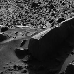
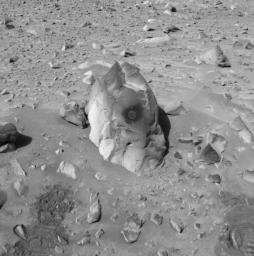
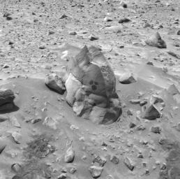
This image, acquired by the Mars Exploration Rover Spirit's panoramic camera on the 53rd martian day, or sol, of the rover's mission, struck science and engineering teams as not only scientifically interesting but remarkably beautiful. The large, shadowed rock in the foreground is nicknamed "Sandia" for a mountain range in New Mexico. An imposing rock, "Sandia" is about 33 centimeters high (1 foot) and about 1.7 meters (5.5 feet) long.

Figure 1 above is a lightened version of the more artistic image above.

The combination of the rover's high-resolution cameras with software tools used by scientists allows the minute details on martian targets to be visualized. When lightened, this image reveals much about the pictured rocks, which the science team believes are ejected material, or ejecta, from the nearby crater called "Bonneville." Scientists believe "Sandia" is a basaltic rock that landed on its side after being ejected from the crater. The vertical lines on the side of the rock facing the camera are known by geologists as "flow banding" and typically run horizontally, indicating that "Sandia" is on its side. What look like small holes on the two visible sides of the rock are called vesicles; they were probably once gas bubbles within the lava.

The lighting not only makes for an artistic image, it helps scientists get a virtual three-dimensional feel for target rocks. Observations taken at different times of day, as shadows move and surface texture details on target rocks are revealed, are entered into modeling software that turns a two-dimensional image into a three-dimensional research tool.

Many smaller rocks can be seen in the background of the image. Some rocks are completely exposed, while others are only peeking out of the surface. Scientists believe that two processes might be at work here: accretion, which occurs when winds deposit material that slowly buries many of the rocks; and deflation, which occurs when surface material is removed by wind, exposing more and more of the rocks.


Signaler ce message à un modérateur | IP: Logguée
Temps en ligne : 8 Jours, 15 Heures, 44 Minutes, 21 Secondes en ligne

Old Post 06-03-2004 08:25
Cliquez ici pour voir le profil de Seth Cliquez ici pour lui envoyer un message privé  Trouver plus de messages de Seth Ajouter Seth à votre liste d'amis Editer/Effacer le Message Citer le message dans la réponse
 Seth  Rechercher tous les messages de ce membre Cliquez ici pour envoyer un message privé à cet utilisateur
Confirmé

Déconnecté

Niveau : 3
N° de Membre : 1512

Ancienneté : 100%
Participation : 2%
Inscription: 07 May 2002
Localisation:
Messages: 1390
Sujets Lancés : 70


http://photojournal.jpl.nasa.gov/jp...5503_modest.jpg
PIA05503.tif (2.228 MB) http://photojournal.jpl.nasa.gov/tiff/PIA05503.tif

Citation:
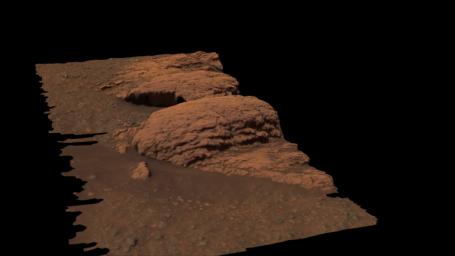
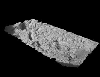
This three dimensional model shows a region of the outcrop near the Mars Exploration Rover Opportunity's landing site dubbed "Last Chance." The model was created with images taken by the rover's panoramic camera. The layered rocks were recently the subject of an extensive series of microscopic images.


Signaler ce message à un modérateur | IP: Logguée
Temps en ligne : 8 Jours, 15 Heures, 44 Minutes, 21 Secondes en ligne

Old Post 06-03-2004 08:26
Cliquez ici pour voir le profil de Seth Cliquez ici pour lui envoyer un message privé  Trouver plus de messages de Seth Ajouter Seth à votre liste d'amis Editer/Effacer le Message Citer le message dans la réponse
 Seth  Rechercher tous les messages de ce membre Cliquez ici pour envoyer un message privé à cet utilisateur
Confirmé

Déconnecté

Niveau : 3
N° de Membre : 1512

Ancienneté : 100%
Participation : 2%
Inscription: 07 May 2002
Localisation:
Messages: 1390
Sujets Lancés : 70


http://photojournal.jpl.nasa.gov/jp...5498_modest.jpg
PIA05498.tif (1.481 MB) http://photojournal.jpl.nasa.gov/tiff/PIA05498.tif

Citation:
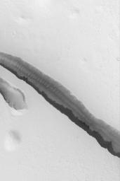
This Mars Global Surveyor (MGS) Mars Orbiter Camera (MOC) image shows a trough in the Cerberus region of Mars formed by faults as the crust in this area was pulled apart. The trough walls and floor have a few large boulders on them, and some large windblown ripples are also present. The image is located near 9.1°N, 197.1°W, and covers an area 3 km (1.9 mi) wide. Sunlight illuminates the scene from the lower left.


Signaler ce message à un modérateur | IP: Logguée
Temps en ligne : 8 Jours, 15 Heures, 44 Minutes, 21 Secondes en ligne

Old Post 06-03-2004 08:27
Cliquez ici pour voir le profil de Seth Cliquez ici pour lui envoyer un message privé  Trouver plus de messages de Seth Ajouter Seth à votre liste d'amis Editer/Effacer le Message Citer le message dans la réponse
 Seth  Rechercher tous les messages de ce membre Cliquez ici pour envoyer un message privé à cet utilisateur
Confirmé

Déconnecté

Niveau : 3
N° de Membre : 1512

Ancienneté : 100%
Participation : 2%
Inscription: 07 May 2002
Localisation:
Messages: 1390
Sujets Lancés : 70


http://photojournal.jpl.nasa.gov/jp...5499_modest.jpg
PIA05499.tif (872.7 kB) http://photojournal.jpl.nasa.gov/tiff/PIA05499.tif

Citation:
This image taken by the navigation camera onboard the Mars Exploration Rover Spirit shows a hole drilled by the rover in the rock dubbed "Humphrey." Spirit ground into the rock with the rock abrasion tool located on its robotic arm on the 60th martian day, or sol, of its mission. Scientists are investigating the freshly exposed rock with the rover's suite of scientific instruments, also located on the rover's arm. Spirit is on its way to a large crater nicknamed "Bonneville".


Signaler ce message à un modérateur | IP: Logguée
Temps en ligne : 8 Jours, 15 Heures, 44 Minutes, 21 Secondes en ligne

Old Post 06-03-2004 08:28
Cliquez ici pour voir le profil de Seth Cliquez ici pour lui envoyer un message privé  Trouver plus de messages de Seth Ajouter Seth à votre liste d'amis Editer/Effacer le Message Citer le message dans la réponse
 Seth  Rechercher tous les messages de ce membre Cliquez ici pour envoyer un message privé à cet utilisateur
Confirmé

Déconnecté

Niveau : 3
N° de Membre : 1512

Ancienneté : 100%
Participation : 2%
Inscription: 07 May 2002
Localisation:
Messages: 1390
Sujets Lancés : 70


http://photojournal.jpl.nasa.gov/jp...5500_modest.jpg
PIA05500.tif (1.05 MB) http://photojournal.jpl.nasa.gov/tiff/PIA05500.tif

Citation:

http://photojournal.jpl.nasa.gov/fi...A05500_fig1.jpg
This image taken by the microscopic imager onboard the Mars Exploration Rover Spirit shows a close-up look at the rock dubbed "Humphrey." The image was taken after the rover drilled into the rock with its rock abrasion tool, exposing fresh rock underneath. Scientists are examining "Humphrey" for clues to its past with the rover's suite of scientific instruments, located on the rover's arm along with its rock abrasion tool. This image was taken on the 60th martian day, or sol, of Spirit's mission. The rover is on its way to a large crater nicknamed "Bonneville".

Natural or Manmade?
The circled areas in Figure 1 above represent features that scientists have identified as being either natural or induced by grinding processes. The yellow circle shows a natural mark; the green and blue circles highlights droppings thought to be left by the rover's Moessbauer spectrometer; and the red circle contains a natural indentation. The image was taken on the 60th martian day, or sol, of the rover's mission.


Signaler ce message à un modérateur | IP: Logguée
Temps en ligne : 8 Jours, 15 Heures, 44 Minutes, 21 Secondes en ligne

Old Post 06-03-2004 08:30
Cliquez ici pour voir le profil de Seth Cliquez ici pour lui envoyer un message privé  Trouver plus de messages de Seth Ajouter Seth à votre liste d'amis Editer/Effacer le Message Citer le message dans la réponse
 Seth  Rechercher tous les messages de ce membre Cliquez ici pour envoyer un message privé à cet utilisateur
Confirmé

Déconnecté

Niveau : 3
N° de Membre : 1512

Ancienneté : 100%
Participation : 2%
Inscription: 07 May 2002
Localisation:
Messages: 1390
Sujets Lancés : 70


http://photojournal.jpl.nasa.gov/jp...5501_modest.jpg
PIA05501.tif (2.352 MB) http://photojournal.jpl.nasa.gov/tiff/PIA05501.tif

Citation:
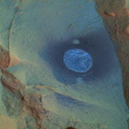
This false-color image taken by the panoramic camera on the Mars Exploration Rover Spirit shows the rock dubbed "Humphrey" and the hole drilled into the rock by the rover. Spirit ground into the rock with the rock abrasion tool located on its robotic arm on the 60th martian day, or sol, of its mission. Scientists are investigating the freshly exposed rock with the scientific instruments on the arm. Spirit is about halfway to a large crater nicknamed "Bonneville." This image was made by combining data from the camera's different wavelength filters. The particular filters used were chosen to enhance features of scientific interest.


Signaler ce message à un modérateur | IP: Logguée
Temps en ligne : 8 Jours, 15 Heures, 44 Minutes, 21 Secondes en ligne

Old Post 06-03-2004 08:32
Cliquez ici pour voir le profil de Seth Cliquez ici pour lui envoyer un message privé  Trouver plus de messages de Seth Ajouter Seth à votre liste d'amis Editer/Effacer le Message Citer le message dans la réponse
 Seth  Rechercher tous les messages de ce membre Cliquez ici pour envoyer un message privé à cet utilisateur
Confirmé

Déconnecté

Niveau : 3
N° de Membre : 1512

Ancienneté : 100%
Participation : 2%
Inscription: 07 May 2002
Localisation:
Messages: 1390
Sujets Lancés : 70


http://photojournal.jpl.nasa.gov/jp...5502_modest.jpg
PIA05502.tif (924.7 kB) http://photojournal.jpl.nasa.gov/tiff/PIA05502.tif


Citation:
This image taken by the navigation camera on the Mars Exploration Rover Spirit shows the rock dubbed "Humphrey" and the circular areas on the rock that were wiped off by the rover. The rover used a brush on its rock abrasion tool to clean these spots before examining them with its miniature thermal emission spectrometer. Later, the rover drilled into the rock with its rock abrasion tool, exposing fresh rock underneath.


Signaler ce message à un modérateur | IP: Logguée
Temps en ligne : 8 Jours, 15 Heures, 44 Minutes, 21 Secondes en ligne

Old Post 06-03-2004 08:33
Cliquez ici pour voir le profil de Seth Cliquez ici pour lui envoyer un message privé  Trouver plus de messages de Seth Ajouter Seth à votre liste d'amis Editer/Effacer le Message Citer le message dans la réponse
 Seth  Rechercher tous les messages de ce membre Cliquez ici pour envoyer un message privé à cet utilisateur
Confirmé

Déconnecté

Niveau : 3
N° de Membre : 1512

Ancienneté : 100%
Participation : 2%
Inscription: 07 May 2002
Localisation:
Messages: 1390
Sujets Lancés : 70


http://photojournal.jpl.nasa.gov/jp...5504_modest.jpg
PIA05504.tif (693.4 kB) http://photojournal.jpl.nasa.gov/tiff/PIA05504.tif

Citation:
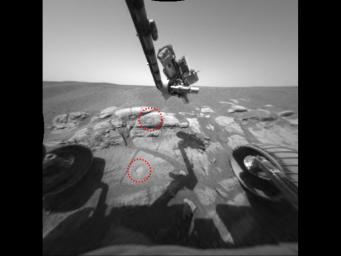
This image taken by the Mars Exploration Rover Opportunity shows the two holes that allowed scientists to peer into Meridiani Planum's wet past. The rover drilled the holes into rocks in the region dubbed "El Capitan" with its rock abrasion tool. By analyzing the freshly exposed rock with the rover's suite of scientific instruments, scientists gathered evidence that this part of Mars may have once been drenched in water. The lower hole, located on a target called "McKittrick," was made on the 30th martian day, or sol, of Opportunity's journey. The upper hole, located on a target called "Guadalupe" was made on the 34th sol of the rover's mission. This image was taken on the 35th martian day, or sol, by the rover's hazard-avoidance camera. The rock abrasion tool and scientific instruments are located on the rover's robotic arm.


Signaler ce message à un modérateur | IP: Logguée
Temps en ligne : 8 Jours, 15 Heures, 44 Minutes, 21 Secondes en ligne

Old Post 06-03-2004 08:34
Cliquez ici pour voir le profil de Seth Cliquez ici pour lui envoyer un message privé  Trouver plus de messages de Seth Ajouter Seth à votre liste d'amis Editer/Effacer le Message Citer le message dans la réponse
 Seth  Rechercher tous les messages de ce membre Cliquez ici pour envoyer un message privé à cet utilisateur
Confirmé

Déconnecté

Niveau : 3
N° de Membre : 1512

Ancienneté : 100%
Participation : 2%
Inscription: 07 May 2002
Localisation:
Messages: 1390
Sujets Lancés : 70


http://photojournal.jpl.nasa.gov/jp...5505_modest.jpg
PIA05505.tif (3.924 MB) http://photojournal.jpl.nasa.gov/tiff/PIA05505.tif

Citation:
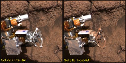
This image taken by the Mars Exploration Rover Opportunity's panoramic camera shows the rover's rock abrasion tool before and after it ground into a rock at Meridiani Planum, Mars. The red dust coating on the instrument is thought to be a form of the mineral hematite. The image on the left was taken on the 29th martian day, or sol, of the rover's mission, and the image on the right on the 31st sol.


Signaler ce message à un modérateur | IP: Logguée
Temps en ligne : 8 Jours, 15 Heures, 44 Minutes, 21 Secondes en ligne

Old Post 06-03-2004 08:35
Cliquez ici pour voir le profil de Seth Cliquez ici pour lui envoyer un message privé  Trouver plus de messages de Seth Ajouter Seth à votre liste d'amis Editer/Effacer le Message Citer le message dans la réponse
 Seth  Rechercher tous les messages de ce membre Cliquez ici pour envoyer un message privé à cet utilisateur
Confirmé

Déconnecté

Niveau : 3
N° de Membre : 1512

Ancienneté : 100%
Participation : 2%
Inscription: 07 May 2002
Localisation:
Messages: 1390
Sujets Lancés : 70


http://photojournal.jpl.nasa.gov/jp...5506_modest.jpg

Citation:
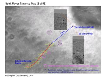
This map shows the path the Mars Exploration Rover Spirit will travel toward its future target, the large crater dubbed "Bonneville." The red line indicates Spirit's travels up to the 59th martian day, or sol, of its journey, and the blue line, the route it will follow. Engineers pinpointed the rover's exact location by comparing images taken by the panoramic camera on the rover (inset panels) to those acquired during descent by the descent image motion estimation system camera (underlying map).


Signaler ce message à un modérateur | IP: Logguée
Temps en ligne : 8 Jours, 15 Heures, 44 Minutes, 21 Secondes en ligne

Old Post 06-03-2004 08:36
Cliquez ici pour voir le profil de Seth Cliquez ici pour lui envoyer un message privé  Trouver plus de messages de Seth Ajouter Seth à votre liste d'amis Editer/Effacer le Message Citer le message dans la réponse
 Seth  Rechercher tous les messages de ce membre Cliquez ici pour envoyer un message privé à cet utilisateur
Confirmé

Déconnecté

Niveau : 3
N° de Membre : 1512

Ancienneté : 100%
Participation : 2%
Inscription: 07 May 2002
Localisation:
Messages: 1390
Sujets Lancés : 70


http://photojournal.jpl.nasa.gov/jp...5507_modest.jpg

Citation:
This three-dimensional model shows a postage-stamp-sized patch of the rock target in the outcrop near the Mars Exploration Rover Opportunity's landing site. A sliced sphere-like particle, or "blueberry," can be seen to the far right of the model. The model was created from images taken by the rover's microscopic imager, after the surface of the rock was scraped away with the rock abrasion tool.


Signaler ce message à un modérateur | IP: Logguée
Temps en ligne : 8 Jours, 15 Heures, 44 Minutes, 21 Secondes en ligne

Old Post 06-03-2004 08:37
Cliquez ici pour voir le profil de Seth Cliquez ici pour lui envoyer un message privé  Trouver plus de messages de Seth Ajouter Seth à votre liste d'amis Editer/Effacer le Message Citer le message dans la réponse
Il est actuellement 13:46 (GMT) Poster un nouveau sujet    Poster une réponse   
Page(s) (49): [ <<   <   17   18   19   20   21   22   23   24   25   26   27   28   29   30   31   32   33   34   35   >   >> ]  Sujet précédent   Sujet suivant
Forum OXMO > Section Généraliste > Discussion Libre > Je vous parle en direct de Mars (Opportunity a atterri !)

Aller au Forum:
Notez ce sujet :


 Réponse Rapide
Titre: (Optionnel)
Message:

Convertir automatiquement les URLs Montrer la Signature
Afficher une version imprimable | Envoyer cette page par email | S'inscrire à ce sujet | Télécharger ce sujet
Règles du forum :
Créer de nouveaux sujets
Répondre aux messages
Attacher des fichiers
Editer vos messages
: not autorisé
: not autorisé
: not autorisé
: not autorisé
Le Code HTML est OFF
Le Code vB est ON
Les Smileys sont ONs
Le code [IMG] est ON
 
< Contactez-nous - Forum OXMO>

Uptime du serveur SQL : 2 jour(s) 13 heure(s) et 22 minute(s)
Page générée en 0.014578 secondes en exécutant 42 requêtes SQL.
Apache - Compression GZIP : Activée.