Accueil Foire Aux Questions Trouver d'autres membres Rechercher Utilisez le vBpad pour stocker des notes personnelles Ici, vous pouvez voir les sujets auxquels vous avez souscris, vos messages privés; et modifier vos informations personnelles et préférences. Statistiques du forum Enregistrez vous gratuitement ! Se déconnecter  
Forum OXMO Forum OXMO > Section Généraliste > Discussion Libre > Je vous parle en direct de Mars (Opportunity a atterri !)


Aller au Forum:
Notez ce sujet :

Page(s) (49): [ <<   <   20   21   22   23   24   25   26   27   28   29   30   31   32   33   34   35   36   37   38   >   >> ]   Sujet précédent   Sujet suivant
Auteur
Sujet Poster un nouveau sujet    Poster une réponse
 Seth  Rechercher tous les messages de ce membre Cliquez ici pour envoyer un message privé à cet utilisateur
Confirmé

Déconnecté

Niveau : 3
N° de Membre : 1512

Ancienneté : 100%
Participation : 2%
Inscription: 07 May 2002
Localisation:
Messages: 1390
Sujets Lancés : 70


http://photojournal.jpl.nasa.gov/jp...5540_modest.jpg
PIA05540.tif (704.9 kB) http://photojournal.jpl.nasa.gov/tiff/PIA05540.tif

Citation:
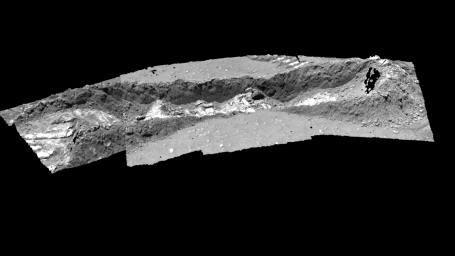
This image shows a three-dimensional model of the trench dug by the Mars Exploration Rover Spirit at a shallow depression dubbed "Laguna Hollow" on the 47th martian day, or sol, of its mission. The rover dragged one of its wheels back and forth across the surface to create this 7-centimeter-deep (3-inch) hole. Afterwards, it investigated the freshly exposed soil with the scientific instruments located on its robotic arm. This model is displayed using software developed by NASA's Ames Research Center. Images from the rover's panoramic camera were used to make the model.


Signaler ce message à un modérateur | IP: Logguée
Temps en ligne : 8 Jours, 15 Heures, 44 Minutes, 21 Secondes en ligne

Old Post 12-03-2004 00:31
Cliquez ici pour voir le profil de Seth Cliquez ici pour lui envoyer un message privé  Trouver plus de messages de Seth Ajouter Seth à votre liste d'amis Editer/Effacer le Message Citer le message dans la réponse
 Seth  Rechercher tous les messages de ce membre Cliquez ici pour envoyer un message privé à cet utilisateur
Confirmé

Déconnecté

Niveau : 3
N° de Membre : 1512

Ancienneté : 100%
Participation : 2%
Inscription: 07 May 2002
Localisation:
Messages: 1390
Sujets Lancés : 70


http://photojournal.jpl.nasa.gov/jp...5541_modest.jpg
PIA05541.tif (749.4 kB) http://photojournal.jpl.nasa.gov/tiff/PIA05541.tif

Citation:
This image shows a three-dimensional model of the rock dubbed "Humphrey" at Gusev Crater, Mars, the Mars Exploration Rover Spirit's landing site. Spirit examined the lumpy rock with its suite of scientific instruments both before and after it drilled a hole into the rock surface on the 60th martian day, or sol, of its mission. "Humphrey" was one of several stops on the rover's way to the large crater dubbed "Bonneville." This model is displayed using software developed by NASA's Ames Research Center. Images from the rover's panoramic camera were used to make the model.


Signaler ce message à un modérateur | IP: Logguée
Temps en ligne : 8 Jours, 15 Heures, 44 Minutes, 21 Secondes en ligne

Old Post 12-03-2004 00:32
Cliquez ici pour voir le profil de Seth Cliquez ici pour lui envoyer un message privé  Trouver plus de messages de Seth Ajouter Seth à votre liste d'amis Editer/Effacer le Message Citer le message dans la réponse
 Seth  Rechercher tous les messages de ce membre Cliquez ici pour envoyer un message privé à cet utilisateur
Confirmé

Déconnecté

Niveau : 3
N° de Membre : 1512

Ancienneté : 100%
Participation : 2%
Inscription: 07 May 2002
Localisation:
Messages: 1390
Sujets Lancés : 70


http://photojournal.jpl.nasa.gov/jp...5542_modest.jpg
PIA05542.tif (790.9 kB) http://photojournal.jpl.nasa.gov/tiff/PIA05542.tif

Citation:
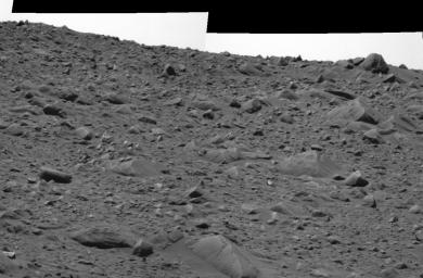
This image taken by the panoramic camera on the Mars Exploration Rover Spirit shows the rocky road the rover traversed to reach its current position 16 meters (52 feet) away from the rim of the crater called "Bonneville." The terrain here slopes upward about five degrees. To the upper right is the rock dubbed "Hole Point," which is about 60 centimeters (two feet) across. This image was taken on the 63rd martian day, or sol, of Spirit's mission.


Signaler ce message à un modérateur | IP: Logguée
Temps en ligne : 8 Jours, 15 Heures, 44 Minutes, 21 Secondes en ligne

Old Post 12-03-2004 00:34
Cliquez ici pour voir le profil de Seth Cliquez ici pour lui envoyer un message privé  Trouver plus de messages de Seth Ajouter Seth à votre liste d'amis Editer/Effacer le Message Citer le message dans la réponse
 Seth  Rechercher tous les messages de ce membre Cliquez ici pour envoyer un message privé à cet utilisateur
Confirmé

Déconnecté

Niveau : 3
N° de Membre : 1512

Ancienneté : 100%
Participation : 2%
Inscription: 07 May 2002
Localisation:
Messages: 1390
Sujets Lancés : 70


http://photojournal.jpl.nasa.gov/jp...5545_modest.jpg

Citation:
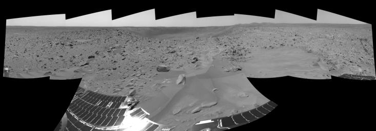
On the 66th martian day, or sol, of its mission, the Mars Exploration Rover Spirit finished a drive and sent back this navigation camera panorama showing "Bonneville" crater and the rocky plains surrounding it. The rover's solar panels are visible in the foreground, and the to right, the Columbia Hills complex. Zooming into the picture, the rover's parachute can be seen as a tiny white dot at the far left, and just above the far crater rim is the heatsheild, visible as a tiny reflective speck.


Signaler ce message à un modérateur | IP: Logguée
Temps en ligne : 8 Jours, 15 Heures, 44 Minutes, 21 Secondes en ligne

Old Post 12-03-2004 00:35
Cliquez ici pour voir le profil de Seth Cliquez ici pour lui envoyer un message privé  Trouver plus de messages de Seth Ajouter Seth à votre liste d'amis Editer/Effacer le Message Citer le message dans la réponse
 Seth  Rechercher tous les messages de ce membre Cliquez ici pour envoyer un message privé à cet utilisateur
Confirmé

Déconnecté

Niveau : 3
N° de Membre : 1512

Ancienneté : 100%
Participation : 2%
Inscription: 07 May 2002
Localisation:
Messages: 1390
Sujets Lancés : 70


http://photojournal.jpl.nasa.gov/jp...5548_modest.jpg
PIA05548.tif (5.278 MB) http://photojournal.jpl.nasa.gov/tiff/PIA05548.tif

Citation:
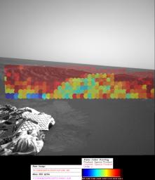
These maps, created with data from the miniature thermal emission spectrometer, an instrument located on the Mars Exploration Rover Opportunity's panoramic camera mast assembly, show the hematite abundance as detected by the instrument from inside the crater at Opportunity's landing site. Hematite data was taken at infrared wavelengths to create these maps, which have been superimposed on images from the rover's navigation camera to provide the visual context of how the hematite is distributed across the martian surface. The hematite abundance has been color-coded, with blue showing relatively no abundance to red showing about 20 percent abundance. Each roughly circular spot represents a single observation by the instrument.


Signaler ce message à un modérateur | IP: Logguée
Temps en ligne : 8 Jours, 15 Heures, 44 Minutes, 21 Secondes en ligne

Old Post 12-03-2004 22:41
Cliquez ici pour voir le profil de Seth Cliquez ici pour lui envoyer un message privé  Trouver plus de messages de Seth Ajouter Seth à votre liste d'amis Editer/Effacer le Message Citer le message dans la réponse
 Seth  Rechercher tous les messages de ce membre Cliquez ici pour envoyer un message privé à cet utilisateur
Confirmé

Déconnecté

Niveau : 3
N° de Membre : 1512

Ancienneté : 100%
Participation : 2%
Inscription: 07 May 2002
Localisation:
Messages: 1390
Sujets Lancés : 70


http://photojournal.jpl.nasa.gov/jp...5549_modest.jpg
PIA05549.tif (1.483 MB) http://photojournal.jpl.nasa.gov/tiff/PIA05549.tif

Citation:
These maps, acquired from the Mars Exploration Rover Opportunity prior to the rover's roll-off, are shown along with data collected at the five locations the rover visited along the Meridiani Planum rock outcrop (dubbed "Alpha," "Bravo," "Charlie," Delta," and "Echo"). The data, collected by the rover's miniature thermal emission spectrometer, has been superimposed on images taken by the navigation camera. The areas investigated are different sizes because of the differing distances from the rover. The bright red region behind the rover has one of the highest hematite concentrations observed in the crater. The areas on the floor of the crater and in the outcrop that the rover has been sampling have much lower hematite concentrations than those found on the surrounding plains. Data from the miniature thermal emission spectrometer show that the floor of the crater is covered with basaltic sand.


Signaler ce message à un modérateur | IP: Logguée
Temps en ligne : 8 Jours, 15 Heures, 44 Minutes, 21 Secondes en ligne

Old Post 12-03-2004 22:43
Cliquez ici pour voir le profil de Seth Cliquez ici pour lui envoyer un message privé  Trouver plus de messages de Seth Ajouter Seth à votre liste d'amis Editer/Effacer le Message Citer le message dans la réponse
 Seth  Rechercher tous les messages de ce membre Cliquez ici pour envoyer un message privé à cet utilisateur
Confirmé

Déconnecté

Niveau : 3
N° de Membre : 1512

Ancienneté : 100%
Participation : 2%
Inscription: 07 May 2002
Localisation:
Messages: 1390
Sujets Lancés : 70


http://photojournal.jpl.nasa.gov/jp...5550_modest.jpg
PIA05550.tif (1.67 MB) http://photojournal.jpl.nasa.gov/tiff/PIA05550.tif

Citation:
This image shows the hematite abundance map for a portion of the Meridiani Planum rock outcrop near where the Mars Exploration Rover Opportunity landed. It was acquired by the rover's miniature thermal emission spectrometer instrument from a spot called "Echo." Portions of the inner crater wall in this region appear rich in hematite (red). The sharp boundary from hematite-rich to hematite-poor (yellow and green) surfaces corresponds to a change in the surface texture and color. The hematite-rich surfaces have ripple-like forms suggesting wind transported hematite to these surfaces. The bounce marks produced during landing at the base of the slope on the left are low in hematite (blue). The hematite grains that originally covered the surface were pushed below the surface by the lander, exposing a soil that has less hematite.


Signaler ce message à un modérateur | IP: Logguée
Temps en ligne : 8 Jours, 15 Heures, 44 Minutes, 21 Secondes en ligne

Old Post 12-03-2004 22:44
Cliquez ici pour voir le profil de Seth Cliquez ici pour lui envoyer un message privé  Trouver plus de messages de Seth Ajouter Seth à votre liste d'amis Editer/Effacer le Message Citer le message dans la réponse
 Seth  Rechercher tous les messages de ce membre Cliquez ici pour envoyer un message privé à cet utilisateur
Confirmé

Déconnecté

Niveau : 3
N° de Membre : 1512

Ancienneté : 100%
Participation : 2%
Inscription: 07 May 2002
Localisation:
Messages: 1390
Sujets Lancés : 70


http://photojournal.jpl.nasa.gov/jp...5558_modest.jpg
PIA05558.tif (299.9 kB) http://photojournal.jpl.nasa.gov/tiff/PIA05558.tif

Citation:
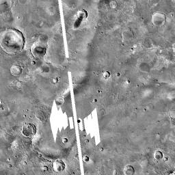
The white boxes in this figure indicate the "footprints" of the Mars Global Surveyor thermal emission spectrometer data over the Opportunity landing site, indicated by a black dot. The footprints to the left of the site were acquired as the spacecraft approached. The line through the rover (shown by a dot), was acquired as the spacecraft passed overhead. The footprints to the right were acquired as the orbiter's instrument looked backward during departure.


Signaler ce message à un modérateur | IP: Logguée
Temps en ligne : 8 Jours, 15 Heures, 44 Minutes, 21 Secondes en ligne

Old Post 13-03-2004 08:32
Cliquez ici pour voir le profil de Seth Cliquez ici pour lui envoyer un message privé  Trouver plus de messages de Seth Ajouter Seth à votre liste d'amis Editer/Effacer le Message Citer le message dans la réponse
 Seth  Rechercher tous les messages de ce membre Cliquez ici pour envoyer un message privé à cet utilisateur
Confirmé

Déconnecté

Niveau : 3
N° de Membre : 1512

Ancienneté : 100%
Participation : 2%
Inscription: 07 May 2002
Localisation:
Messages: 1390
Sujets Lancés : 70


http://photojournal.jpl.nasa.gov/jp...5561_modest.jpg
PIA05561.tif (615.9 kB) http://photojournal.jpl.nasa.gov/tiff/PIA05561.tif

Citation:
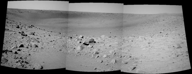
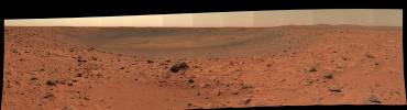
The Mars Exploration Rover Spirit took this navigation camera mosaic of the crater called "Bonneville" after driving approximately 13 meters (42.7 feet) to get a better vantage point. Spirit's current position is close enough to the edge to see the interior of the crater, but high enough and far enough back to get a view of all of the walls. Because scientists and rover controllers are so pleased with this location, they will stay here for at least two more martian days, or sols, to take high resolution panoramic camera images of "Bonneville" in its entirety. Just above the far crater rim, on the left side, is the rover's heatshield, which is visible as a tiny reflective speck.


Signaler ce message à un modérateur | IP: Logguée
Temps en ligne : 8 Jours, 15 Heures, 44 Minutes, 21 Secondes en ligne

Old Post 13-03-2004 08:33
Cliquez ici pour voir le profil de Seth Cliquez ici pour lui envoyer un message privé  Trouver plus de messages de Seth Ajouter Seth à votre liste d'amis Editer/Effacer le Message Citer le message dans la réponse
 Seth  Rechercher tous les messages de ce membre Cliquez ici pour envoyer un message privé à cet utilisateur
Confirmé

Déconnecté

Niveau : 3
N° de Membre : 1512

Ancienneté : 100%
Participation : 2%
Inscription: 07 May 2002
Localisation:
Messages: 1390
Sujets Lancés : 70


http://photojournal.jpl.nasa.gov/jp...5563_modest.jpg
PIA05563.tif (957.6 kB) http://photojournal.jpl.nasa.gov/tiff/PIA05563.tif

Citation:

http://photojournal.jpl.nasa.gov/fi...A05563_fig1.jpg

Scientists are hunting down the recipe for the "blueberries" they've discovered on Mars. Taken with the Mars Exploration Rover Opportunity's front hazard-avoidance camera on the 45th martian day, or sol, of the rover's mission (March 10, 2004), this image shows the area dubbed "Berry Bowl," where many dark and mysterious spherules or "blueberries" collected in a depression on the surface of a rock. Opportunity is studying the blueberries for clues to their chemical composition with its suite of scientific instruments. 'Berry Bowl' is located within the rock outcrop that lines the inner edge of the crater where the rover landed.


Signaler ce message à un modérateur | IP: Logguée
Temps en ligne : 8 Jours, 15 Heures, 44 Minutes, 21 Secondes en ligne

Old Post 13-03-2004 08:35
Cliquez ici pour voir le profil de Seth Cliquez ici pour lui envoyer un message privé  Trouver plus de messages de Seth Ajouter Seth à votre liste d'amis Editer/Effacer le Message Citer le message dans la réponse
 Seth  Rechercher tous les messages de ce membre Cliquez ici pour envoyer un message privé à cet utilisateur
Confirmé

Déconnecté

Niveau : 3
N° de Membre : 1512

Ancienneté : 100%
Participation : 2%
Inscription: 07 May 2002
Localisation:
Messages: 1390
Sujets Lancés : 70


http://photojournal.jpl.nasa.gov/jp...5564_modest.jpg
PIA05564.tif (3.818 MB) http://photojournal.jpl.nasa.gov/tiff/PIA05564.tif

Citation:
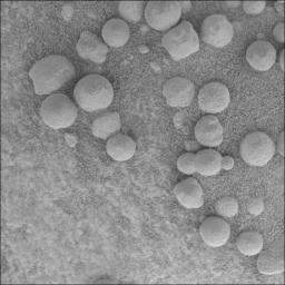
Scientists are hunting down the recipe for the "blueberries" they've discovered on Mars with the Mars Exploration Rover Opportunity. For location of the area dubbed "Berry Bowl" see PIA05563.
To figure out the chemical composition of the blueberries, scientists are currently analyzing the area shown in the microscopic image with the rover's alpha particle X-ray spectrometer and Moessbauer spectrometer. The field of view for the alpha particle X-ray spectrometer is about equal to the field of view of the microscopic image and the field of view for the Moessbauer spectrometer is about half the size of the microscopic image, so the spectrometers will observe a mix of sand, rock, and blueberries. The blueberries are too small to analyze alone. Scientists will discern the blueberry spectra, or light signatures, from the observed blend of spectra by subtracting out the known sand and rock spectra. Basically, finding the blueberry recipe is like making a recipe in reverse. Chemical measurements of the sand were taken earlier, and a measurement of the same rock in an area clear of the blueberries will be taken with the spectrometers on sol 48.

The "triple berry" seen in the center of the microscopic image is intriguing to scientists because it reveals a clue about how the blueberries formed. Spheres formed from impacts or volcanoes do not tend to mold together like the spheres seen in the microscopic image. Spheres from impacts or craters are usually round or teardrop-shaped from flying in the air and freezing before hitting the ground. Any droplets of magma that combine with other droplets usually grow into a single mass in a spherical, dumbbell, or teardrop shape. In contrast, concretions could form this triple berry shape. Concretions are spherical mineral structures formed by groundwater percolating through porous rocks. On Earth, as concretions grow in close proximity to each other, their outer edges often intersect each other, giving an appearance like a triple soap bubble.


Signaler ce message à un modérateur | IP: Logguée
Temps en ligne : 8 Jours, 15 Heures, 44 Minutes, 21 Secondes en ligne

Old Post 13-03-2004 08:36
Cliquez ici pour voir le profil de Seth Cliquez ici pour lui envoyer un message privé  Trouver plus de messages de Seth Ajouter Seth à votre liste d'amis Editer/Effacer le Message Citer le message dans la réponse
 Seth  Rechercher tous les messages de ce membre Cliquez ici pour envoyer un message privé à cet utilisateur
Confirmé

Déconnecté

Niveau : 3
N° de Membre : 1512

Ancienneté : 100%
Participation : 2%
Inscription: 07 May 2002
Localisation:
Messages: 1390
Sujets Lancés : 70


http://photojournal.jpl.nasa.gov/jp...5570_modest.jpg
PIA05570.tif (97.61 MB) http://photojournal.jpl.nasa.gov/tiff/PIA05570.tif

Citation:
The rim and interior of a crater nicknamed "Bonneville" dominate this 180-degree, false-color mosaic of images taken by the panoramic camera of NASA's Mars Exploration Rover Spirit. Spirit recorded this view on the rover's 68th sol, March 12, 2004, one sol after reaching this location. The rover remaining here in part to get this very high-resolution, color mosaic, from which scientists can gain insight about the depth of the surface material at Bonneville and make future observation plans. On sol 71, Spirit was instructed to drive approximately 15 meters (49 feet) along the crater rim to a new vantage point.


Signaler ce message à un modérateur | IP: Logguée
Temps en ligne : 8 Jours, 15 Heures, 44 Minutes, 21 Secondes en ligne

Old Post 15-03-2004 22:18
Cliquez ici pour voir le profil de Seth Cliquez ici pour lui envoyer un message privé  Trouver plus de messages de Seth Ajouter Seth à votre liste d'amis Editer/Effacer le Message Citer le message dans la réponse
 Solacin  Rechercher tous les messages de ce membre Cliquez ici pour envoyer un message privé à cet utilisateur
Guru

Déconnecté

Niveau : 5
N° de Membre : 11117

Ancienneté : 96%
Participation : 10%
Inscription: 23 Mar 2003
Localisation: 974
Age: 52
Messages: 8253
Sujets Lancés : 28

Pffffffff, ils foutent quoi a la NASA !!!!! ils ont toujours pas identifiés ce qu'étaient ces petites boules


__________________


Signaler ce message à un modérateur | IP: Logguée
Temps en ligne : 25 Jours, 5 Heures, 18 Minutes, 53 Secondes en ligne

Old Post 16-03-2004 06:18
Cliquez ici pour voir le profil de Solacin Cliquez ici pour lui envoyer un message privé  Trouver plus de messages de Solacin Ajouter Solacin à votre liste d'amis       Editer/Effacer le Message Citer le message dans la réponse
 Seth  Rechercher tous les messages de ce membre Cliquez ici pour envoyer un message privé à cet utilisateur
Confirmé

Déconnecté

Niveau : 3
N° de Membre : 1512

Ancienneté : 100%
Participation : 2%
Inscription: 07 May 2002
Localisation:
Messages: 1390
Sujets Lancés : 70

They say it is 'Blueberry'


Signaler ce message à un modérateur | IP: Logguée
Temps en ligne : 8 Jours, 15 Heures, 44 Minutes, 21 Secondes en ligne

Old Post 16-03-2004 14:23
Cliquez ici pour voir le profil de Seth Cliquez ici pour lui envoyer un message privé  Trouver plus de messages de Seth Ajouter Seth à votre liste d'amis Editer/Effacer le Message Citer le message dans la réponse
 Seth  Rechercher tous les messages de ce membre Cliquez ici pour envoyer un message privé à cet utilisateur
Confirmé

Déconnecté

Niveau : 3
N° de Membre : 1512

Ancienneté : 100%
Participation : 2%
Inscription: 07 May 2002
Localisation:
Messages: 1390
Sujets Lancés : 70


http://photojournal.jpl.nasa.gov/jp...5572_modest.jpg

Citation:
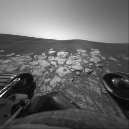
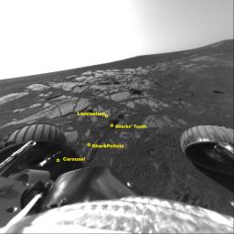
In its 49th sol on Mars, NASA's Opportunity had nearly concluded its scientific examination of the extreme southwestern end of the outcrop in Meridiani Planum. In the "Shark's Cage" area of the neighborhood called "Shoemaker's Patio," featured in this image from the front hazard avoidance camera, Opportunity deployed its arm to study the features called "Shark's Tooth," "Shark Pellets," and "Lamination." "Shark's Tooth" is a piece of the unusual red rind that appears to fill cracks in the outcrop. This rind may be some kind of chemical alteration of the rocks. "Shark Pellets" is an area of soil that was under investigation as part of the crater soil survey. "Lamination" is a target with very thin layers that resemble uniform pages in a book, an indication of how the sediments were deposited. A final experiment in this area will be attempted on sol 51. Opportunity's front left wheel will "scuff" the rock called "Carousel." "Scuffing" involves scraping the rock with one wheel while holding all the others still. This experiment essentially turns the rover wheels into tools, to try and determine the hardness of the target rock.


Signaler ce message à un modérateur | IP: Logguée
Temps en ligne : 8 Jours, 15 Heures, 44 Minutes, 21 Secondes en ligne

Old Post 17-03-2004 05:18
Cliquez ici pour voir le profil de Seth Cliquez ici pour lui envoyer un message privé  Trouver plus de messages de Seth Ajouter Seth à votre liste d'amis Editer/Effacer le Message Citer le message dans la réponse
Il est actuellement 12:27 (GMT) Poster un nouveau sujet    Poster une réponse   
Page(s) (49): [ <<   <   20   21   22   23   24   25   26   27   28   29   30   31   32   33   34   35   36   37   38   >   >> ]  Sujet précédent   Sujet suivant
Forum OXMO > Section Généraliste > Discussion Libre > Je vous parle en direct de Mars (Opportunity a atterri !)

Aller au Forum:
Notez ce sujet :


 Réponse Rapide
Titre: (Optionnel)
Message:

Convertir automatiquement les URLs Montrer la Signature
Afficher une version imprimable | Envoyer cette page par email | S'inscrire à ce sujet | Télécharger ce sujet
Règles du forum :
Créer de nouveaux sujets
Répondre aux messages
Attacher des fichiers
Editer vos messages
: not autorisé
: not autorisé
: not autorisé
: not autorisé
Le Code HTML est OFF
Le Code vB est ON
Les Smileys sont ONs
Le code [IMG] est ON
 
< Contactez-nous - Forum OXMO>

Uptime du serveur SQL : 2 jour(s) 12 heure(s) et 3 minute(s)
Page générée en 0.015682 secondes en exécutant 42 requêtes SQL.
Apache - Compression GZIP : Activée.