Accueil Foire Aux Questions Trouver d'autres membres Rechercher Utilisez le vBpad pour stocker des notes personnelles Ici, vous pouvez voir les sujets auxquels vous avez souscris, vos messages privés; et modifier vos informations personnelles et préférences. Statistiques du forum Enregistrez vous gratuitement ! Se déconnecter  
Forum OXMO Forum OXMO > Section Généraliste > Discussion Libre > Je vous parle en direct de Mars (Opportunity a atterri !)


Aller au Forum:
Notez ce sujet :

Page(s) (49): [ <<   <   21   22   23   24   25   26   27   28   29   30   31   32   33   34   35   36   37   38   39   >   >> ]   Sujet précédent   Sujet suivant
Auteur
Sujet Poster un nouveau sujet    Poster une réponse
 Seth  Rechercher tous les messages de ce membre Cliquez ici pour envoyer un message privé à cet utilisateur
Confirmé

Déconnecté

Niveau : 3
N° de Membre : 1512

Ancienneté : 100%
Participation : 2%
Inscription: 07 May 2002
Localisation:
Messages: 1390
Sujets Lancés : 70


http://photojournal.jpl.nasa.gov/jp...5573_modest.jpg

Citation:
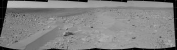
While the interior and far walls of the crater dubbed "Bonneville" can be seen in the background, the dominant foreground features in this 180-degree navigation camera mosaic are the wind-deposited drifts of dust or sand. NASA's Mars Exploration Rover Spirit completed this mosaic on sol 71, March 15, 2004, from its newest location at the rim of "Bonneville" crater.
Scientists are interested in these formations in part because they might give insight into the processes that formed some of the material within the crater. Thermal emission measurements by the rover indicate that the dark material just below the far rim of this crater is spectrally similar to rocks that scientists have analyzed along their journey to this location. They want to know why this soil-like material has a spectrum that more closely resembles rocks rather than other soils examined so far. The drifts seen in the foreground of this mosaic might have the answer. Scientists hypothesize that these drifts might consist of wind-deposited particles that are the same as the dark material found against the back wall of the crater. If so, Spirit may spend time studying the material and help scientists understand why it is different from other fine-grained material seen at Gusev.

The drifts appear to be lighter in color than the dark material deposited on the back wall of the crater. They might be covered by a thin deposit of martian dust, or perhaps the drift is like other drifts seen during Spirit's journey and is just a collection of martian dust.

To find out, Spirit will spend some of sol 72 digging its wheels into the drift to uncover its interior. After backing up a bit, Spirit will use the panoramic camera and miniature thermal emission spectrometer to analyze the scuffed area. If the interior material has a similar spectrum to the dark deposit in the crater, then Spirit will most likely stay here a little longer to study the drift with the instruments on its robotic arm. If the material is uniform - that is, dusty all the way down, Spirit will most likely move off to another target.


Signaler ce message à un modérateur | IP: Logguée
Temps en ligne : 8 Jours, 15 Heures, 44 Minutes, 21 Secondes en ligne

Old Post 17-03-2004 05:19
Cliquez ici pour voir le profil de Seth Cliquez ici pour lui envoyer un message privé  Trouver plus de messages de Seth Ajouter Seth à votre liste d'amis Editer/Effacer le Message Citer le message dans la réponse
 Seth  Rechercher tous les messages de ce membre Cliquez ici pour envoyer un message privé à cet utilisateur
Confirmé

Déconnecté

Niveau : 3
N° de Membre : 1512

Ancienneté : 100%
Participation : 2%
Inscription: 07 May 2002
Localisation:
Messages: 1390
Sujets Lancés : 70


http://photojournal.jpl.nasa.gov/jp...5574_modest.jpg
PIA05574.tif (1.587 MB) http://photojournal.jpl.nasa.gov/tiff/PIA05574.tif

Citation:
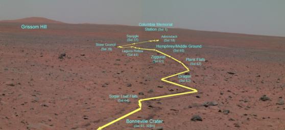
This false-color panoramic camera composite traverse map depicts the Mars Exploration Rover Spirit's journey since landing at Gusev Crater, Mars. It was generated from three of the camera's different wavelength filters (750 nanometers, 530 nanometers and 480 nanometers). This map was created on the 65th martian day, or sol, of Spirit's mission, after Spirit had traveled 328 meters (1076 feet) from its lander to the rim of the crater dubbed "Bonneville." From this high point, Spirit was able to capture with its panoramic camera the entire rover traverse. The map points out major stops that Spirit made along the way, including features nicknamed "Adirondack;" "Stone Council;" "Laguna Hollow;" and "Humphrey." Also highlighted is the landscape feature informally named "Grissom Hill" and Spirit's landing site, the Columbia Memorial Station.


Signaler ce message à un modérateur | IP: Logguée
Temps en ligne : 8 Jours, 15 Heures, 44 Minutes, 21 Secondes en ligne

Old Post 18-03-2004 00:09
Cliquez ici pour voir le profil de Seth Cliquez ici pour lui envoyer un message privé  Trouver plus de messages de Seth Ajouter Seth à votre liste d'amis Editer/Effacer le Message Citer le message dans la réponse
 Seth  Rechercher tous les messages de ce membre Cliquez ici pour envoyer un message privé à cet utilisateur
Confirmé

Déconnecté

Niveau : 3
N° de Membre : 1512

Ancienneté : 100%
Participation : 2%
Inscription: 07 May 2002
Localisation:
Messages: 1390
Sujets Lancés : 70


http://photojournal.jpl.nasa.gov/jp...5575_modest.jpg
PIA05575.tif (940.4 kB) http://photojournal.jpl.nasa.gov/tiff/PIA05575.tif

Citation:
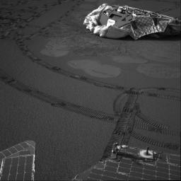
The Mars Exploration Rover Opportunity finished observations of the prominent rock outcrop it has been studying during its 51 martian days, or sols, on Mars, and is currently on the hunt for new discoveries. This image from the rover's navigation camera atop its mast features Opportunity's lander--its temporary home for the six-month cruise to Mars. The rover's soil survey traverse plan involves arcing around its landing site, called the Challenger Memorial Station, and over the trench it made on sol 23. In this image, Opportunity is situated about 6.2 meters (about 20.3 feet) from the lander. Rover tracks zig-zag along the surface. Bounce marks and airbag retraction marks are visible around the lander. The calibration target or sundial, which both rover panoramic cameras use to verify the true colors and brightness of the red planet, is visible on the back end of the rover.


Signaler ce message à un modérateur | IP: Logguée
Temps en ligne : 8 Jours, 15 Heures, 44 Minutes, 21 Secondes en ligne

Old Post 18-03-2004 00:10
Cliquez ici pour voir le profil de Seth Cliquez ici pour lui envoyer un message privé  Trouver plus de messages de Seth Ajouter Seth à votre liste d'amis Editer/Effacer le Message Citer le message dans la réponse
 Seth  Rechercher tous les messages de ce membre Cliquez ici pour envoyer un message privé à cet utilisateur
Confirmé

Déconnecté

Niveau : 3
N° de Membre : 1512

Ancienneté : 100%
Participation : 2%
Inscription: 07 May 2002
Localisation:
Messages: 1390
Sujets Lancés : 70


http://photojournal.jpl.nasa.gov/jp...5577_modest.jpg

Citation:
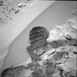
The Mars Exploration Rover Spirit acquired this navigation camera image on the 72nd martian day, or sol, of its mission (March 15, 2004), after digging its wheel into the drift dubbed "Serpent." Creating the commands that would generate this "scar" was not an easy task for rover controllers. Essentially, they had to choreograph an intricate dance for Spirit, maneuvering it up the side of the dune, shimmying its left front wheel a number of times to create the scuff, and then reversing to attain proper positioning for miniature thermal emission spectrometer observations. Before the task was finished, Spirit moved forward to put the scuff within proper reach of the rover's arm.
This scar allows the rover's instruments to see below the drift surface, to determine the composition of the materials. Initial results indicate that the drift material is similar to the basaltic sands that have been seen throughout Spirit's journey to the large crater dubbed "Bonneville." The material does not seem to be the same as that inside the crater.

Scientists are now looking to answer two questions: Why is the dark sand in the crater not the same as the dark sand in the drift? And why are there two different dark soil-type deposits in such a small place?


Signaler ce message à un modérateur | IP: Logguée
Temps en ligne : 8 Jours, 15 Heures, 44 Minutes, 21 Secondes en ligne

Old Post 18-03-2004 00:11
Cliquez ici pour voir le profil de Seth Cliquez ici pour lui envoyer un message privé  Trouver plus de messages de Seth Ajouter Seth à votre liste d'amis Editer/Effacer le Message Citer le message dans la réponse
 Solacin  Rechercher tous les messages de ce membre Cliquez ici pour envoyer un message privé à cet utilisateur
Guru

Déconnecté

Niveau : 5
N° de Membre : 11117

Ancienneté : 96%
Participation : 10%
Inscription: 23 Mar 2003
Localisation: 974
Age: 52
Messages: 8253
Sujets Lancés : 28

Pffff, non mais ils s'amusent là les mecs hein !!!
"they had to choreograph an intricate dance for Spirit"


__________________


Signaler ce message à un modérateur | IP: Logguée
Temps en ligne : 25 Jours, 5 Heures, 18 Minutes, 53 Secondes en ligne

Old Post 18-03-2004 04:29
Cliquez ici pour voir le profil de Solacin Cliquez ici pour lui envoyer un message privé  Trouver plus de messages de Solacin Ajouter Solacin à votre liste d'amis       Editer/Effacer le Message Citer le message dans la réponse
 Seth  Rechercher tous les messages de ce membre Cliquez ici pour envoyer un message privé à cet utilisateur
Confirmé

Déconnecté

Niveau : 3
N° de Membre : 1512

Ancienneté : 100%
Participation : 2%
Inscription: 07 May 2002
Localisation:
Messages: 1390
Sujets Lancés : 70


http://photojournal.jpl.nasa.gov/jp...5581_modest.jpg
PIA05581.tif (2.15 MB) http://photojournal.jpl.nasa.gov/tiff/PIA05581.tif

Citation:
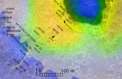
The route of NASA's Mars Exploration Rover Spirit, from its landing site to its location on sol 72 (March 16, 2004) near the rim of the large crater dubbed "Bonneville" is pictured here on this traverse map. The map consists of data from NASA's Mars Global Surveyor orbiter and NASA's Mars Odyssey orbiter. The varying terrains surrounding Bonneville--crater floor, crater wall, crater rim, crater ejecta (material ejected from the crater) and intercrater plains--are highlighted in different colors.


Signaler ce message à un modérateur | IP: Logguée
Temps en ligne : 8 Jours, 15 Heures, 44 Minutes, 21 Secondes en ligne

Old Post 18-03-2004 22:33
Cliquez ici pour voir le profil de Seth Cliquez ici pour lui envoyer un message privé  Trouver plus de messages de Seth Ajouter Seth à votre liste d'amis Editer/Effacer le Message Citer le message dans la réponse
 Seth  Rechercher tous les messages de ce membre Cliquez ici pour envoyer un message privé à cet utilisateur
Confirmé

Déconnecté

Niveau : 3
N° de Membre : 1512

Ancienneté : 100%
Participation : 2%
Inscription: 07 May 2002
Localisation:
Messages: 1390
Sujets Lancés : 70


http://photojournal.jpl.nasa.gov/jp...5582_modest.jpg
PIA05582.tif (818.5 kB) http://photojournal.jpl.nasa.gov/tiff/PIA05582.tif

Citation:
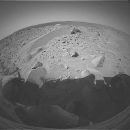
A drift dubbed "Serpent" stretches in front of NASA's Mars Exploration Rover Spirit in this picture from the left eye of Spirit's front hazard-avoidance camera. Spirit took the image during its 71st martian day, or sol, on Mars (March 15, 2004) while exploring the rim of the crater nicknamed "Bonneville." The following sol, the rover used its wheels to dig into the drift and expose material under the surface.


Signaler ce message à un modérateur | IP: Logguée
Temps en ligne : 8 Jours, 15 Heures, 44 Minutes, 21 Secondes en ligne

Old Post 18-03-2004 22:34
Cliquez ici pour voir le profil de Seth Cliquez ici pour lui envoyer un message privé  Trouver plus de messages de Seth Ajouter Seth à votre liste d'amis Editer/Effacer le Message Citer le message dans la réponse
 Seth  Rechercher tous les messages de ce membre Cliquez ici pour envoyer un message privé à cet utilisateur
Confirmé

Déconnecté

Niveau : 3
N° de Membre : 1512

Ancienneté : 100%
Participation : 2%
Inscription: 07 May 2002
Localisation:
Messages: 1390
Sujets Lancés : 70


http://photojournal.jpl.nasa.gov/jp...5583_modest.jpg
PIA05583.tif (929.4 kB) http://photojournal.jpl.nasa.gov/tiff/PIA05583.tif

Citation:
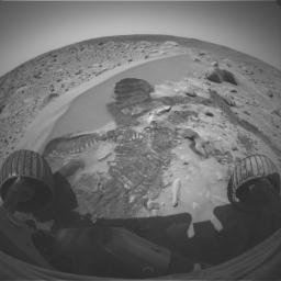
NASA's Mars Exploration Rover Spirit acquired this image on the 72nd martian day, or sol, of its mission (March 15, 2004) with the left eye of its front hazard-identification camera after digging its wheel into the drift dubbed "Serpent." Creating the commands that would generate this scar was not an easy task for rover controllers. Essentially, they had to choreograph an intricate dance for Spirit, maneuvering it up the side of the dune, shimmying its left front wheel a number of times to create the scuff, and then reversing to attain proper positioning for miniature thermal emission spectrometer observations. Before the task was finished, Spirit moved forward to put the scuff within proper reach of the rover's arm.
This scar allows the rover's instruments to see below the drift surface, to determine the composition of its materials. Initial results indicate that the drift material is similar to the basaltic sands that have been seen throughout Spirit's journey to the large crater dubbed "Bonneville." The material does not seem to be the same as that inside the crater.

Two questions raised by these results are: Why is the dark sand in the crater not the same as the dark sand in the drift? And why are there two different dark soil-type deposits in such a small place?


Signaler ce message à un modérateur | IP: Logguée
Temps en ligne : 8 Jours, 15 Heures, 44 Minutes, 21 Secondes en ligne

Old Post 18-03-2004 22:35
Cliquez ici pour voir le profil de Seth Cliquez ici pour lui envoyer un message privé  Trouver plus de messages de Seth Ajouter Seth à votre liste d'amis Editer/Effacer le Message Citer le message dans la réponse
 Seth  Rechercher tous les messages de ce membre Cliquez ici pour envoyer un message privé à cet utilisateur
Confirmé

Déconnecté

Niveau : 3
N° de Membre : 1512

Ancienneté : 100%
Participation : 2%
Inscription: 07 May 2002
Localisation:
Messages: 1390
Sujets Lancés : 70


http://photojournal.jpl.nasa.gov/jp...5584_modest.jpg
PIA05584.tif (1.951 MB) http://photojournal.jpl.nasa.gov/tiff/PIA05584.tif

Citation:
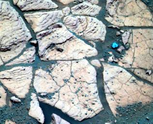
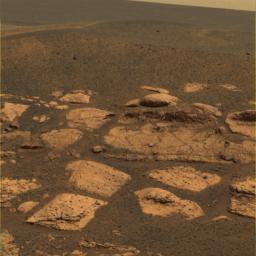
This false-color composite image, taken at a region of the rock outcrop dubbed "Shoemaker's Patio" near the Mars Exploration Rover Opportunity's landing site, shows finely layered sediments, which have been accentuated by erosion. The sphere-like grains or "blueberries" distributed throughout the outcrop can be seen lining up with individual layers. This observation indicates that the spherules are geologic features called concretions, which form in pre-existing wet sediments. Other sphere-like grains, such as impact spherules or volcanic lapilli (fragments of material etween 2 and 64 millimeters or .08 and 2.5 inches in maximum dimension that are ejected from a volcano) are thought to be deposited with sediments and thus would form layers distinct from those of the rocks. This image was captured by the rover's panoramic camera on the 50th martian day, or sol, of the mission. Data from the camera's infrared, green and violet filters were used to create this false-color picture.


Signaler ce message à un modérateur | IP: Logguée
Temps en ligne : 8 Jours, 15 Heures, 44 Minutes, 21 Secondes en ligne

Old Post 19-03-2004 04:19
Cliquez ici pour voir le profil de Seth Cliquez ici pour lui envoyer un message privé  Trouver plus de messages de Seth Ajouter Seth à votre liste d'amis Editer/Effacer le Message Citer le message dans la réponse
 Seth  Rechercher tous les messages de ce membre Cliquez ici pour envoyer un message privé à cet utilisateur
Confirmé

Déconnecté

Niveau : 3
N° de Membre : 1512

Ancienneté : 100%
Participation : 2%
Inscription: 07 May 2002
Localisation:
Messages: 1390
Sujets Lancés : 70


http://photojournal.jpl.nasa.gov/jp...5585_modest.jpg
PIA05585.tif (790.7 kB) http://photojournal.jpl.nasa.gov/tiff/PIA05585.tif

Citation:
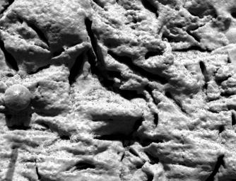
This microscopic image, taken at the outcrop region dubbed "El Capitan" near the Mars Exploration Rover Opportunity's landing site, reveals millimeter-scale (.04 inch-scale) layers in the lower portion. This same layering is hinted at by the fine notches that run horizontally across the sphere-like grain or "blueberry" in the center left. The thin layers do not appear to deform around the blueberry, indicating that these geologic features are concretions and not impact spherules or ejected volcanic material called lapilli. Concretions are balls of minerals that form in pre-existing wet sediments. This image was taken by the rover's microscopic imager on the 29th martian day, or sol, of its mission. The observed area is about 3 centimeters (1.2 inches) across.


Signaler ce message à un modérateur | IP: Logguée
Temps en ligne : 8 Jours, 15 Heures, 44 Minutes, 21 Secondes en ligne

Old Post 19-03-2004 04:20
Cliquez ici pour voir le profil de Seth Cliquez ici pour lui envoyer un message privé  Trouver plus de messages de Seth Ajouter Seth à votre liste d'amis Editer/Effacer le Message Citer le message dans la réponse
 Seth  Rechercher tous les messages de ce membre Cliquez ici pour envoyer un message privé à cet utilisateur
Confirmé

Déconnecté

Niveau : 3
N° de Membre : 1512

Ancienneté : 100%
Participation : 2%
Inscription: 07 May 2002
Localisation:
Messages: 1390
Sujets Lancés : 70


http://photojournal.jpl.nasa.gov/jp...5586_modest.jpg
PIA05586.tif (675.8 kB) http://photojournal.jpl.nasa.gov/tiff/PIA05586.tif

Citation:
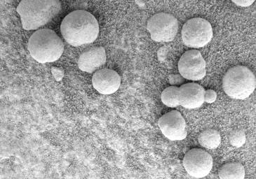
This microscopic image, taken at the outcrop region dubbed "Berry Bowl" near the Mars Exploration Rover Opportunity's landing site, shows the sphere-like grains or "blueberries" that fill Berry Bowl. Of particular interest is the blueberry triplet, which indicates that these geologic features grew in pre-existing wet sediments. Other sphere-like grains that form in the air, such as impact spherules or ejected volcanic material called lapilli, are unlikely to fuse along a line and form triplets. This image was taken by the rover's microscopic imager on the 46th martian day, or sol, of its mission.


Signaler ce message à un modérateur | IP: Logguée
Temps en ligne : 8 Jours, 15 Heures, 44 Minutes, 21 Secondes en ligne

Old Post 19-03-2004 04:21
Cliquez ici pour voir le profil de Seth Cliquez ici pour lui envoyer un message privé  Trouver plus de messages de Seth Ajouter Seth à votre liste d'amis Editer/Effacer le Message Citer le message dans la réponse
 Seth  Rechercher tous les messages de ce membre Cliquez ici pour envoyer un message privé à cet utilisateur
Confirmé

Déconnecté

Niveau : 3
N° de Membre : 1512

Ancienneté : 100%
Participation : 2%
Inscription: 07 May 2002
Localisation:
Messages: 1390
Sujets Lancés : 70


http://photojournal.jpl.nasa.gov/jp...5588_modest.jpg
PIA05588.tif (3.132 MB) http://photojournal.jpl.nasa.gov/tiff/PIA05588.tif

Citation:
This approximate true-color image suggests that the plains beyond the small crater where the Mars Exploration Rover Opportunity now sits are littered with the same dark grey material found inside the crater in the form of spherules or "blueberries." Because Mars orbiters have observed the iron-bearing mineral hematite across these plains, scientists hypothesize that the blueberries are also made up of this mineral. This image was taken by the rover's panoramic camera on the 17th martian day, or sol, of its mission. Data from the camera's red, green and blue filters were combined to create this image.


Signaler ce message à un modérateur | IP: Logguée
Temps en ligne : 8 Jours, 15 Heures, 44 Minutes, 21 Secondes en ligne

Old Post 19-03-2004 04:23
Cliquez ici pour voir le profil de Seth Cliquez ici pour lui envoyer un message privé  Trouver plus de messages de Seth Ajouter Seth à votre liste d'amis Editer/Effacer le Message Citer le message dans la réponse
 Seth  Rechercher tous les messages de ce membre Cliquez ici pour envoyer un message privé à cet utilisateur
Confirmé

Déconnecté

Niveau : 3
N° de Membre : 1512

Ancienneté : 100%
Participation : 2%
Inscription: 07 May 2002
Localisation:
Messages: 1390
Sujets Lancés : 70


http://photojournal.jpl.nasa.gov/jp...5590_modest.jpg
PIA05590.tif (1.295 MB) http://photojournal.jpl.nasa.gov/tiff/PIA05590.tif

Citation:
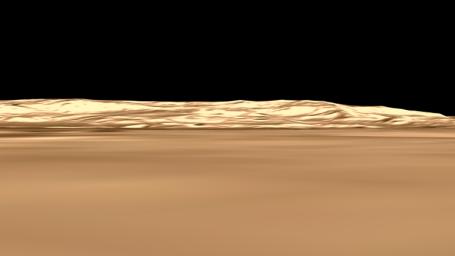
This is a still from an animation showing the geography of Ma'adim Vallis, a valley or channel that enters Gusev Crater. The view of the crater is from the northwest, which is not the direction from which Spirit approached the crater as it landed.


Signaler ce message à un modérateur | IP: Logguée
Temps en ligne : 8 Jours, 15 Heures, 44 Minutes, 21 Secondes en ligne

Old Post 19-03-2004 04:24
Cliquez ici pour voir le profil de Seth Cliquez ici pour lui envoyer un message privé  Trouver plus de messages de Seth Ajouter Seth à votre liste d'amis Editer/Effacer le Message Citer le message dans la réponse
 Seth  Rechercher tous les messages de ce membre Cliquez ici pour envoyer un message privé à cet utilisateur
Confirmé

Déconnecté

Niveau : 3
N° de Membre : 1512

Ancienneté : 100%
Participation : 2%
Inscription: 07 May 2002
Localisation:
Messages: 1390
Sujets Lancés : 70


http://photojournal.jpl.nasa.gov/jp...5589_modest.jpg
PIA05589.tif (364.9 kB) http://photojournal.jpl.nasa.gov/tiff/PIA05589.tif

Citation:
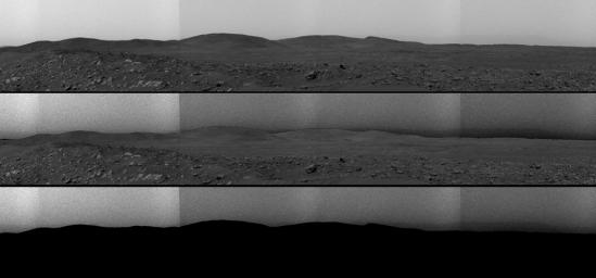
This top image is a panorama mosaic taken by the Mars Exploration Rover Spirit panoramic camera on sol 68 of the rover's mission (March 12, 2004). The southern end of the hills nicknamed the "Columbia Hills" can be seen on the left near the horizon. The middle image shows the same view, but the sky has been further processed to show contrast, bringing out a feature that dips along the rim of Gusev Crater. The feature, toward the right of the image, is a valley called Ma'adim Vallis that appears to go through the crater. In the bottom version of the image, the foreground is masked for better viewing of the Gusev Crater rim, which at its closest point is approximately 50 miles (80 kilometers) away from Spirit.


Signaler ce message à un modérateur | IP: Logguée
Temps en ligne : 8 Jours, 15 Heures, 44 Minutes, 21 Secondes en ligne

Old Post 19-03-2004 04:25
Cliquez ici pour voir le profil de Seth Cliquez ici pour lui envoyer un message privé  Trouver plus de messages de Seth Ajouter Seth à votre liste d'amis Editer/Effacer le Message Citer le message dans la réponse
 Seth  Rechercher tous les messages de ce membre Cliquez ici pour envoyer un message privé à cet utilisateur
Confirmé

Déconnecté

Niveau : 3
N° de Membre : 1512

Ancienneté : 100%
Participation : 2%
Inscription: 07 May 2002
Localisation:
Messages: 1390
Sujets Lancés : 70


http://photojournal.jpl.nasa.gov/jp...5591_modest.jpg
PIA05591.tif (72.35 MB) http://photojournal.jpl.nasa.gov/tiff/PIA05591.tif


Citation:
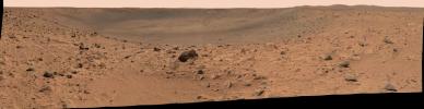
This panoramic image mosaic from the Mars Exploration Rover Spirit panoramic camera, shows the rover's destination toward the hills nicknamed the "Columbia Hills," on the right. The rover's heatshield can be seen on the left as a tiny bright dot in the distance, just under the horizon. Dark drift material can be seen in the image center. The rover is currently positioned outside the view of this image, on the right. This image was taken on sols 68 and 69 of Spirit's mission (March 12 and 13, 2004) from the location the rover first reached on the western rim of the crater. The image is in approximate true color, based on a scaling of data from the red, green and blue (750 nanometers, 530 nanometers, and 480 nanometers) filters.


Signaler ce message à un modérateur | IP: Logguée
Temps en ligne : 8 Jours, 15 Heures, 44 Minutes, 21 Secondes en ligne

Old Post 19-03-2004 04:27
Cliquez ici pour voir le profil de Seth Cliquez ici pour lui envoyer un message privé  Trouver plus de messages de Seth Ajouter Seth à votre liste d'amis Editer/Effacer le Message Citer le message dans la réponse
Il est actuellement 13:47 (GMT) Poster un nouveau sujet    Poster une réponse   
Page(s) (49): [ <<   <   21   22   23   24   25   26   27   28   29   30   31   32   33   34   35   36   37   38   39   >   >> ]  Sujet précédent   Sujet suivant
Forum OXMO > Section Généraliste > Discussion Libre > Je vous parle en direct de Mars (Opportunity a atterri !)

Aller au Forum:
Notez ce sujet :


 Réponse Rapide
Titre: (Optionnel)
Message:

Convertir automatiquement les URLs Montrer la Signature
Afficher une version imprimable | Envoyer cette page par email | S'inscrire à ce sujet | Télécharger ce sujet
Règles du forum :
Créer de nouveaux sujets
Répondre aux messages
Attacher des fichiers
Editer vos messages
: not autorisé
: not autorisé
: not autorisé
: not autorisé
Le Code HTML est OFF
Le Code vB est ON
Les Smileys sont ONs
Le code [IMG] est ON
 
< Contactez-nous - Forum OXMO>

Uptime du serveur SQL : 2 jour(s) 13 heure(s) et 23 minute(s)
Page générée en 0.017486 secondes en exécutant 42 requêtes SQL.
Apache - Compression GZIP : Activée.