Accueil Foire Aux Questions Trouver d'autres membres Rechercher Utilisez le vBpad pour stocker des notes personnelles Ici, vous pouvez voir les sujets auxquels vous avez souscris, vos messages privés; et modifier vos informations personnelles et préférences. Statistiques du forum Enregistrez vous gratuitement ! Se déconnecter  
Forum OXMO Forum OXMO > Section Généraliste > Discussion Libre > Je vous parle en direct de Mars (Opportunity a atterri !)


Aller au Forum:
Notez ce sujet :

Page(s) (49): [ <<   <   23   24   25   26   27   28   29   30   31   32   33   34   35   36   37   38   39   40   41   >   >> ]   Sujet précédent   Sujet suivant
Auteur
Sujet Poster un nouveau sujet    Poster une réponse
 Seth  Rechercher tous les messages de ce membre Cliquez ici pour envoyer un message privé à cet utilisateur
Confirmé

Déconnecté

Niveau : 3
N° de Membre : 1512

Ancienneté : 100%
Participation : 2%
Inscription: 07 May 2002
Localisation:
Messages: 1390
Sujets Lancés : 70


http://photojournal.jpl.nasa.gov/jp...5622_modest.jpg

Citation:

http://photojournal.jpl.nasa.gov/fi...A05622_fig1.jpg
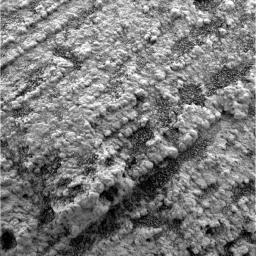
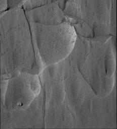
Opportunity took this picture with its microscopic imager during the rover's 42nd sol on Mars (March 6, 2004), the sol before it took a similar picture PIA05520 at the same location. Most of the grains visible resemble medium-sized sand grains and are well-rounded and well-sorted.

A microscopic image (Figure 1) shows variability of grain size within a parallel-stratified portion of the "Slickrock" area in the martian rock outcrop examined by NASA's Opportunity. The dip from left to right is an artifact of the camera pointing angle. The grains in the rock define the fine layers, or laminae, and the variability in grain size along each lamina is small compared to the variability between laminae. Some of the fine layers have mostly smaller grains; others have mostly larger grains. Red arrows and labels indicate the sizes of a representative large grain (0.8 millimeter or 0.03 inch) and a representative small grain (0.3 millimeters or 0.01 inch).


Signaler ce message à un modérateur | IP: Logguée
Temps en ligne : 8 Jours, 15 Heures, 44 Minutes, 21 Secondes en ligne

Old Post 24-03-2004 00:22
Cliquez ici pour voir le profil de Seth Cliquez ici pour lui envoyer un message privé  Trouver plus de messages de Seth Ajouter Seth à votre liste d'amis Editer/Effacer le Message Citer le message dans la réponse
 Solacin  Rechercher tous les messages de ce membre Cliquez ici pour envoyer un message privé à cet utilisateur
Guru

Déconnecté

Niveau : 5
N° de Membre : 11117

Ancienneté : 96%
Participation : 10%
Inscription: 23 Mar 2003
Localisation: 974
Age: 52
Messages: 8253
Sujets Lancés : 28

Ca se précise ....

Citation:

WASHINGTON (AFP) - Le robot américain Opportunity sur la planète Mars a permis d'établir la présence passée d'eau salée composant une mer qui aurait permis la vie, et dans laquelle se sont formés les rochers examinés par le robot.

"Nous pensons qu'Opportunity est situé dans ce qui fut la côte bordant une mer salée sur Mars" a déclaré Steve Squyres, scientifique en chef de la mission Mars Exploration Rover en ajoutant que "nous voyons un environnement permettant la vie".

Le robot a permis de démontrer que certains rochers examinés sur Mars résultent de la sédimentation dans de l'eau salée, ont précisé les responsables de la Nasa, sans pouvoir l'instant déterminer pendant combien de temps cette mer a existé, ni sa taille dans la zone du Meridiani Planum, une grande plaine où est posé le robot Opportunity depuis la fin janvier.

"Ce résultat nous incite à développer notre ambitieux programme d'exploration de Mars pour apprendre si des microbes ont un jour vécu là-bas, et finalement, si nous pouvons" y vivre, a pour sa part estimé Ed Weiler, administrateur adjoint de la Nasa chargé de la science spatiale. Il a qualifié la planète rouge de "planète la plus semblable à la Terre" connue.

Les résultats présentés mardi par la Nasa, lors d'une conférence de presse à son siège de Washington, ont été vérifiés par des experts indépendants avant d'être rendus publics, a précisé l'agence spatiale américaine.

Les chercheurs, qui contrôlent le robot à partir du Jet Propulsion Laboratory de la Nasa à Pasadena (Californie), vont maintenant le faire rouler à travers la plaine, en direction de rochers exposés, qui forment la paroie d'un cratère.

"Des motifs au sein de couches rocheuses fines indiquent des grains de sédiments de la taille du sable qui ont fait corps, ont été ridés par de l'eau sur une profondeur d'au moins cinq centimètres, peut-être beaucoup plus, qui coulait à la vitesse de 10 à 50 centimètres par secondes", a expliqué John Grotzinger, du Massachusetts Institute of Technology de Cambridge (Massachusets).

Opportunity avait déjà fait sensation, début mars, en collectant des indices prouvant que l'eau a un jour été présente en abondance dans la région du Meridiani Planum, où il s'est posé le 24 janvier, précédé par l'autre robot de la Nasa, Spirit, tombé le 3 janvier dans le cratère Gusev, de l'autre côté de Mars.

La mission des robots à six roues était de découvrir si Mars a connu un environnement humide de longue durée permettant la vie. D'un coût de 820 millions de dollars, cette mission mobilise environ 300 chercheurs et doit se poursuivre jusqu'à la fin avril et peut-être davantage si les batteries des robots le permettent.


__________________


Signaler ce message à un modérateur | IP: Logguée
Temps en ligne : 25 Jours, 5 Heures, 18 Minutes, 53 Secondes en ligne

Old Post 24-03-2004 04:54
Cliquez ici pour voir le profil de Solacin Cliquez ici pour lui envoyer un message privé  Trouver plus de messages de Solacin Ajouter Solacin à votre liste d'amis       Editer/Effacer le Message Citer le message dans la réponse
 Seth  Rechercher tous les messages de ce membre Cliquez ici pour envoyer un message privé à cet utilisateur
Confirmé

Déconnecté

Niveau : 3
N° de Membre : 1512

Ancienneté : 100%
Participation : 2%
Inscription: 07 May 2002
Localisation:
Messages: 1390
Sujets Lancés : 70


http://photojournal.jpl.nasa.gov/jp...5623_modest.jpg
PIA05623.tif (1.527 MB) http://photojournal.jpl.nasa.gov/tiff/PIA05623.tif


Citation:
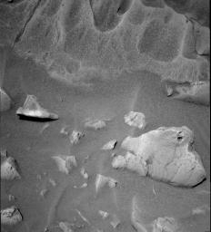
This is an image Opportunity took from a distance of 2.1 meters (6.9 feet) during the rover's 45th sol on Mars (March 10, 2004) and shows a scour surface or ripple trough lamination. These features are consistent with sedimentation on a moist surface where wind-driven processes may also have occurred.

http://photojournal.jpl.nasa.gov/fi...A05623_fig1.jpg
Geological examination of bedding textures (Figure 1) indicates three stratigraphic units in an area called "Slickrock" located in the martian rock outcrop that NASA's Opportunity examined for several weeks. Interpretive blue lines indicate boundaries between the units. The upper blue line may coincide with a scour surface. The lower and upper units have features suggestive of ripples or early soft-sediment deformation. The central unit is dominated by fine, parallel stratification, which could have been produced by wind-blown ripples. Figure 1 shows is a scour surface characterized by truncation of the underlying fine layers, or laminae.

http://photojournal.jpl.nasa.gov/fi...A05623_fig2.jpg
Features labeled with red letters are shown in an enlargement (Figure 2) of portions of the image. Figure 2 shows a possible ripple beneath the arrow and a possible ripple cross-lamination to the left of the arrow, along the surface the arrow tip touches.

http://photojournal.jpl.nasa.gov/fi...A05623_fig3.jpg
Figure 3 shows a possible soft-sediment buckling characterized by a "teepee" shaped structure.


Signaler ce message à un modérateur | IP: Logguée
Temps en ligne : 8 Jours, 15 Heures, 44 Minutes, 21 Secondes en ligne

Old Post 24-03-2004 13:18
Cliquez ici pour voir le profil de Seth Cliquez ici pour lui envoyer un message privé  Trouver plus de messages de Seth Ajouter Seth à votre liste d'amis Editer/Effacer le Message Citer le message dans la réponse
 Seth  Rechercher tous les messages de ce membre Cliquez ici pour envoyer un message privé à cet utilisateur
Confirmé

Déconnecté

Niveau : 3
N° de Membre : 1512

Ancienneté : 100%
Participation : 2%
Inscription: 07 May 2002
Localisation:
Messages: 1390
Sujets Lancés : 70


http://photojournal.jpl.nasa.gov/jp...5624_modest.jpg
PIA05624.tif (6.651 MB) http://photojournal.jpl.nasa.gov/tiff/PIA05624.tif


Citation:

http://photojournal.jpl.nasa.gov/fi...A05624_fig1.jpg
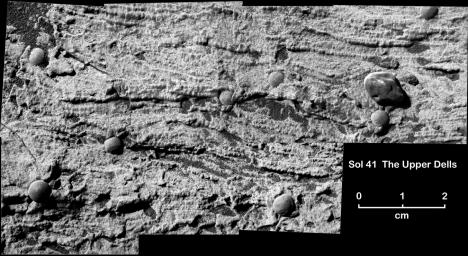
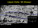
This magnified view from NASA's Mars Exploration Rover Opportunity of a portion of a martian rock called "Upper Dells" shows fine layers (laminae) that are truncated, discordant and at angles to each other. Interpretive black lines trace cross-lamination that indicates the sediments that formed the rock were laid down in flowing water.

This rock, like another called "Last Chance,"
(see PIA05482)
http://photojournal.jpl.nasa.gov/catalog/PIA005482
preserves evidence for trough cross-lamination, likely produced when flowing water shaped sinuous ripples in underwater sediment and pushed the ripples to migrate in one direction. The direction of the ancient flow would have been toward or away from the viewer. The interpretive blue lines (Figure 1) point to boundaries between possible sets of cross-laminae.

Several frames taken with Opportunity's microscopic imager during the rover's 41st sol on Mars (March 5, 2004) are stitched together to make this mosaic view. Eight spherules can be seen embedded in the rock, and one larger pebble sits on the present-day surface of the rock.


Signaler ce message à un modérateur | IP: Logguée
Temps en ligne : 8 Jours, 15 Heures, 44 Minutes, 21 Secondes en ligne

Old Post 24-03-2004 13:20
Cliquez ici pour voir le profil de Seth Cliquez ici pour lui envoyer un message privé  Trouver plus de messages de Seth Ajouter Seth à votre liste d'amis Editer/Effacer le Message Citer le message dans la réponse
 Seth  Rechercher tous les messages de ce membre Cliquez ici pour envoyer un message privé à cet utilisateur
Confirmé

Déconnecté

Niveau : 3
N° de Membre : 1512

Ancienneté : 100%
Participation : 2%
Inscription: 07 May 2002
Localisation:
Messages: 1390
Sujets Lancés : 70


Citation:

http://photojournal.jpl.nasa.gov/fi...A05625_fig1.jpg

This view of the lower portion of the martian rock called "Last Chance"
(see PIA05482)
http://photojournal.jpl.nasa.gov/catalog/PIA05482
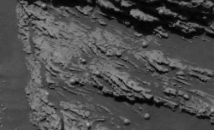
shows a close-up of texture interpreted as cross-lamination evidence that sediments forming the rock were laid down in flowing water. NASA's Opportunity took the original image during the rover's 38th sol in Mars' Meridiani Planum region (March 2, 2004).

In the central part of the image, the dip of fine layers at angles to each other (cross laminae) suggests that the water that created the cross-lamination was flowing from left to right. Interpretive black lines trace these cross-laminae. Interpretive blue lines indicate boundaries of possible sets of cross-laminae (Figure 2).

http://photojournal.jpl.nasa.gov/fi...A05625_fig2.jpg
A three-dimensional visualization of this portion of the rock offers additional details of the cross-lamination. The visualization and the image from the panoramic camera are compared to show a point of correlation (yellow arrow, Figure 2).


Signaler ce message à un modérateur | IP: Logguée
Temps en ligne : 8 Jours, 15 Heures, 44 Minutes, 21 Secondes en ligne

Old Post 24-03-2004 13:23
Cliquez ici pour voir le profil de Seth Cliquez ici pour lui envoyer un message privé  Trouver plus de messages de Seth Ajouter Seth à votre liste d'amis Editer/Effacer le Message Citer le message dans la réponse
 Seth  Rechercher tous les messages de ce membre Cliquez ici pour envoyer un message privé à cet utilisateur
Confirmé

Déconnecté

Niveau : 3
N° de Membre : 1512

Ancienneté : 100%
Participation : 2%
Inscription: 07 May 2002
Localisation:
Messages: 1390
Sujets Lancés : 70


http://photojournal.jpl.nasa.gov/jp...5626_modest.jpg
PIA05626.tif (372.3 kB) http://photojournal.jpl.nasa.gov/tiff/PIA05626.tif


Citation:

http://photojournal.jpl.nasa.gov/fi...A05626_fig1.jpg
A three-dimensional close-up visualization of this portion of the Martian rock called "Last Chance"
(see PIA05482)
http://photojournal.jpl.nasa.gov/catalog/PIA05482
offers additional details of the cross-lamination. The visualization and the image from the panoramic camera are compared to show a point of correlation (yellow arrow, Figure 1).


Signaler ce message à un modérateur | IP: Logguée
Temps en ligne : 8 Jours, 15 Heures, 44 Minutes, 21 Secondes en ligne

Old Post 24-03-2004 13:25
Cliquez ici pour voir le profil de Seth Cliquez ici pour lui envoyer un message privé  Trouver plus de messages de Seth Ajouter Seth à votre liste d'amis Editer/Effacer le Message Citer le message dans la réponse
 Seth  Rechercher tous les messages de ce membre Cliquez ici pour envoyer un message privé à cet utilisateur
Confirmé

Déconnecté

Niveau : 3
N° de Membre : 1512

Ancienneté : 100%
Participation : 2%
Inscription: 07 May 2002
Localisation:
Messages: 1390
Sujets Lancés : 70


http://photojournal.jpl.nasa.gov/jp...5627_modest.jpg
PIA05627.tif (819.3 kB) http://photojournal.jpl.nasa.gov/tiff/PIA05627.tif

Citation:
NASA's Mars Exploration Rover Spirit took this panoramic camera image of the rock target named "Mazatzal" on sol 77 (March 22, 2004). It is a close-up look at the rock face and the targets that will be brushed and ground by the rock abrasion tool in upcoming sols.
Mazatzal, like most rocks on Earth and Mars, has layers of material near its surface that provide clues about the history of the rock. Scientists believe that the top layer of Mazatzal is actually a coating of dust and possibly even salts. Under this light coating may be a more solid portion of the rock that has been chemically altered by weathering. Past this layer is the unaltered rock, which may give scientists the best information about how Mazatzal was formed.

Because each layer reveals information about the formation and subsequent history of Mazatzal, it is important that scientists get a look at each of them. For this reason, they have developed a multi-part strategy to use the rock abrasion tool to systematically peel back Mazatzal's layers and analyze what's underneath with the rover's microscopic imager, and its Moessbauer and alpha particle X-ray spectrometers.

The strategy began on sol 77 when scientists used the microscopic imager to get a closer look at targets on Mazatzal named "New York,\" "Illinois" and "Arizona." These rock areas were targeted because they posed the best opportunity for successfully using the rock abrasion tool; Arizona also allowed for a close-up look at a range of tones. On sol 78, Spirit's rock abrasion tool will do a light brushing on the Illinois target to preserve some of the surface layers. Then, a brushing of the New York target should remove the top coating of any dust and salts and perhaps reveal the chemically altered rock underneath. Finally, on sol 79, the rock abrasion tool will be commanded to grind into the New York target, which will give scientists the best chance of observing Mazatzal's interior.

The Mazatzal targets were named after the home states of some of the rock abrasion tool and science team members.


Signaler ce message à un modérateur | IP: Logguée
Temps en ligne : 8 Jours, 15 Heures, 44 Minutes, 21 Secondes en ligne

Old Post 25-03-2004 05:29
Cliquez ici pour voir le profil de Seth Cliquez ici pour lui envoyer un message privé  Trouver plus de messages de Seth Ajouter Seth à votre liste d'amis Editer/Effacer le Message Citer le message dans la réponse
 Seth  Rechercher tous les messages de ce membre Cliquez ici pour envoyer un message privé à cet utilisateur
Confirmé

Déconnecté

Niveau : 3
N° de Membre : 1512

Ancienneté : 100%
Participation : 2%
Inscription: 07 May 2002
Localisation:
Messages: 1390
Sujets Lancés : 70


http://photojournal.jpl.nasa.gov/jp...5628_modest.jpg
PIA05628.tif (914.8 kB) http://photojournal.jpl.nasa.gov/tiff/PIA05628.tif

Citation:
This black and white panoramic camera image of the rock called "Mazatzal" (top of image) was taken by the Mars Exploration Rover Spirit on sol 76 (March 2, 2004). It reveals some interesting features on this future rock abrasion tool target, including variants in tone, a sugary surface texture and scalloped areas where parts of the rock seem to have been worn away. Mazatzal's uniqueness is made even more obvious when it is compared to the more typical, basaltic rock in the lower right of the image.


Signaler ce message à un modérateur | IP: Logguée
Temps en ligne : 8 Jours, 15 Heures, 44 Minutes, 21 Secondes en ligne

Old Post 25-03-2004 05:30
Cliquez ici pour voir le profil de Seth Cliquez ici pour lui envoyer un message privé  Trouver plus de messages de Seth Ajouter Seth à votre liste d'amis Editer/Effacer le Message Citer le message dans la réponse
 Seth  Rechercher tous les messages de ce membre Cliquez ici pour envoyer un message privé à cet utilisateur
Confirmé

Déconnecté

Niveau : 3
N° de Membre : 1512

Ancienneté : 100%
Participation : 2%
Inscription: 07 May 2002
Localisation:
Messages: 1390
Sujets Lancés : 70


http://photojournal.jpl.nasa.gov/jp...5629_modest.jpg
PIA05629.tif (2.462 MB) http://photojournal.jpl.nasa.gov/tiff/PIA05629.tif

Citation:
This panoramic camera image was taken by NASA's Mars Exploration Rover Spirit on sol 79 after completing a two-location brushing on the rock dubbed "Mazatzal." A coating of fine, dust-like material was successfully removed from targets named "Illinois" (right) and "New York" (left), revealing the weathered rock underneath. In this image, Spirit's panoramic camera mast assembly, or camera head, can be seen shadowing Mazatzal's surface. This approximate true color image was taken with the 601, 535 and 482 nanometer filters.
The center of the two brushed spots are approximately 10 centimeters (3.9 inches) apart and will be aggressively analyzed by the instruments on the robotic arm on sol 80. Plans for sol 81 are to grind into the New York target to get past any weathered rock and expose the original, internal rock underneath.


Signaler ce message à un modérateur | IP: Logguée
Temps en ligne : 8 Jours, 15 Heures, 44 Minutes, 21 Secondes en ligne

Old Post 25-03-2004 05:31
Cliquez ici pour voir le profil de Seth Cliquez ici pour lui envoyer un message privé  Trouver plus de messages de Seth Ajouter Seth à votre liste d'amis Editer/Effacer le Message Citer le message dans la réponse
 Seth  Rechercher tous les messages de ce membre Cliquez ici pour envoyer un message privé à cet utilisateur
Confirmé

Déconnecté

Niveau : 3
N° de Membre : 1512

Ancienneté : 100%
Participation : 2%
Inscription: 07 May 2002
Localisation:
Messages: 1390
Sujets Lancés : 70


http://photojournal.jpl.nasa.gov/jp...5630_modest.jpg
PIA05630.tif (77.77 MB) http://photojournal.jpl.nasa.gov/tiff/PIA05630.tif

Citation:
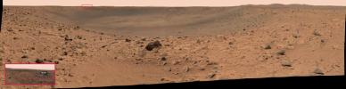
The Mars Exploration Rover Spirit acquired this panoramic camera image mosaic on the 68th martian day, or sol, of its mission (March 12, 2004). The reflective speck about 200 meters (650 feet) away, on the far crater rim, was immediately a point of interest for scientists and engineers alike. They soon were able to identify it as Spirit's protective heatshield.
While the debris is too far away to make out clearly, orbital imagery of the area acquired before and after Spirit landed supports scientists' and engineers' conclusion. Prior to Spirit's landing, the surface at this location appeared undisturbed in orbital images, while post-landing images revealed a large gouge where the heatshield now rests.

The smaller image in the box at the lower left corner provides a closer look at the heatshield, and was taken at a lower compression by the panoramic camera on sol 69 (March 13, 2004). Lower compression results in higher quality images. While both the full panorama and close-up are depicted in approximate true color, their colors vary slightly because different filters were used to acquire them. The close-up image was taken with the 600, 530 and 480 nanometer filters. The large mosaic was taken with the 750, 530 and 480 nanometer filters.


Signaler ce message à un modérateur | IP: Logguée
Temps en ligne : 8 Jours, 15 Heures, 44 Minutes, 21 Secondes en ligne

Old Post 25-03-2004 05:33
Cliquez ici pour voir le profil de Seth Cliquez ici pour lui envoyer un message privé  Trouver plus de messages de Seth Ajouter Seth à votre liste d'amis Editer/Effacer le Message Citer le message dans la réponse
 Solacin  Rechercher tous les messages de ce membre Cliquez ici pour envoyer un message privé à cet utilisateur
Guru

Déconnecté

Niveau : 5
N° de Membre : 11117

Ancienneté : 96%
Participation : 10%
Inscription: 23 Mar 2003
Localisation: 974
Age: 52
Messages: 8253
Sujets Lancés : 28

Aussitot dit, que voila la preuve en image !!!
Merci Seth


__________________


Signaler ce message à un modérateur | IP: Logguée
Temps en ligne : 25 Jours, 5 Heures, 18 Minutes, 53 Secondes en ligne

Old Post 25-03-2004 10:10
Cliquez ici pour voir le profil de Solacin Cliquez ici pour lui envoyer un message privé  Trouver plus de messages de Solacin Ajouter Solacin à votre liste d'amis       Editer/Effacer le Message Citer le message dans la réponse
 Seth  Rechercher tous les messages de ce membre Cliquez ici pour envoyer un message privé à cet utilisateur
Confirmé

Déconnecté

Niveau : 3
N° de Membre : 1512

Ancienneté : 100%
Participation : 2%
Inscription: 07 May 2002
Localisation:
Messages: 1390
Sujets Lancés : 70


http://photojournal.jpl.nasa.gov/jp...5631_modest.jpg
PIA05631.tif (9.014 MB) PIA05631.tif (9.014 MB)

Citation:
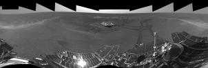
This is the right-eye version of the Mars Exploration Rover Opportunity's view on its 56th sol on Mars, before it left its landing-site crater. To the right, the rover tracks are visible at the original spot where the rover attempted unsuccessfully to exit the crater. After a one-sol delay, Opportunity took another route to the plains of Meridiani Planum. This image was taken by the rover's navigation camera.


Signaler ce message à un modérateur | IP: Logguée
Temps en ligne : 8 Jours, 15 Heures, 44 Minutes, 21 Secondes en ligne

Old Post 26-03-2004 03:10
Cliquez ici pour voir le profil de Seth Cliquez ici pour lui envoyer un message privé  Trouver plus de messages de Seth Ajouter Seth à votre liste d'amis Editer/Effacer le Message Citer le message dans la réponse
 Seth  Rechercher tous les messages de ce membre Cliquez ici pour envoyer un message privé à cet utilisateur
Confirmé

Déconnecté

Niveau : 3
N° de Membre : 1512

Ancienneté : 100%
Participation : 2%
Inscription: 07 May 2002
Localisation:
Messages: 1390
Sujets Lancés : 70


http://photojournal.jpl.nasa.gov/jp...5632_modest.jpg
PIA05632.tif (9.12 MB) http://photojournal.jpl.nasa.gov/tiff/PIA05632.tif

Citation:
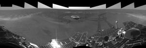
This is the left-eye version of the Mars Exploration Rover Opportunity's view on its 56th sol on Mars, before it left its landing-site crater. To the right, the rover tracks are visible at the original spot where the rover attempted unsuccessfully to exit the crater. After a one-sol delay, Opportunity took another route to the plains of Meridiani Planum. This image was taken by the rover's navigation camera.


Signaler ce message à un modérateur | IP: Logguée
Temps en ligne : 8 Jours, 15 Heures, 44 Minutes, 21 Secondes en ligne

Old Post 26-03-2004 03:11
Cliquez ici pour voir le profil de Seth Cliquez ici pour lui envoyer un message privé  Trouver plus de messages de Seth Ajouter Seth à votre liste d'amis Editer/Effacer le Message Citer le message dans la réponse
 Seth  Rechercher tous les messages de ce membre Cliquez ici pour envoyer un message privé à cet utilisateur
Confirmé

Déconnecté

Niveau : 3
N° de Membre : 1512

Ancienneté : 100%
Participation : 2%
Inscription: 07 May 2002
Localisation:
Messages: 1390
Sujets Lancés : 70


http://photojournal.jpl.nasa.gov/jp...5633_modest.jpg
PIA05633.tif (40.33 MB) http://photojournal.jpl.nasa.gov/tiff/PIA05633.tif

Citation:
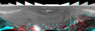
This is the 3-D version of the Mars Exploration Rover Opportunity's view on its 56th sol on Mars, before it left "Eagle Crater." To the right, the rover tracks are visible at the original spot where the rover attempted unsuccessfully to exit the crater. After a one-sol delay, Opportunity took another route to the plains of Meridiani Planum. This image was taken by the rover's navigation camera.


Signaler ce message à un modérateur | IP: Logguée
Temps en ligne : 8 Jours, 15 Heures, 44 Minutes, 21 Secondes en ligne

Old Post 26-03-2004 03:12
Cliquez ici pour voir le profil de Seth Cliquez ici pour lui envoyer un message privé  Trouver plus de messages de Seth Ajouter Seth à votre liste d'amis Editer/Effacer le Message Citer le message dans la réponse
 Seth  Rechercher tous les messages de ce membre Cliquez ici pour envoyer un message privé à cet utilisateur
Confirmé

Déconnecté

Niveau : 3
N° de Membre : 1512

Ancienneté : 100%
Participation : 2%
Inscription: 07 May 2002
Localisation:
Messages: 1390
Sujets Lancés : 70


http://photojournal.jpl.nasa.gov/jp...5634_modest.jpg
PIA05634.tif (1.181 MB) http://photojournal.jpl.nasa.gov/tiff/PIA05634.tif

Citation:
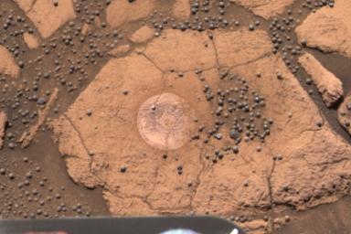
This image from the Mars Exploration Rover Opportunity's panoramic camera is an approximate true-color rendering of the exceptional rock called "Berry Bowl" in the "Eagle Crater" outcrop. The study of this "blueberry-strewn" area and the identification of hematite as the major iron-bearing element within these sphere-like grains helped scientists confirm their hypothesis that the hematite in these martian spherules was deposited in water. To separately analyze the mineralogical content of three main features within this area -- blueberries, dust and rock -- it was important that the rock abrasion tool's brush was able to rest on a relatively berry-free spot. The rock's small size and crowd of berries made the 10-minute brushing a challenge to plan and execute. The successful brushing on the target whimsically referred to as "Near Empty" on the rover's 48th sol on Mars left a dust-free impression for subsequent examination by the rover's spectrometers. No grinding was necessary on the rock because spectral data obtained on the dust-free surface were sufficient to verify that the rock's chemical composition differs significantly from the hematite-rich berries.


Signaler ce message à un modérateur | IP: Logguée
Temps en ligne : 8 Jours, 15 Heures, 44 Minutes, 21 Secondes en ligne

Old Post 26-03-2004 03:14
Cliquez ici pour voir le profil de Seth Cliquez ici pour lui envoyer un message privé  Trouver plus de messages de Seth Ajouter Seth à votre liste d'amis Editer/Effacer le Message Citer le message dans la réponse
Il est actuellement 13:44 (GMT) Poster un nouveau sujet    Poster une réponse   
Page(s) (49): [ <<   <   23   24   25   26   27   28   29   30   31   32   33   34   35   36   37   38   39   40   41   >   >> ]  Sujet précédent   Sujet suivant
Forum OXMO > Section Généraliste > Discussion Libre > Je vous parle en direct de Mars (Opportunity a atterri !)

Aller au Forum:
Notez ce sujet :


 Réponse Rapide
Titre: (Optionnel)
Message:

Convertir automatiquement les URLs Montrer la Signature
Afficher une version imprimable | Envoyer cette page par email | S'inscrire à ce sujet | Télécharger ce sujet
Règles du forum :
Créer de nouveaux sujets
Répondre aux messages
Attacher des fichiers
Editer vos messages
: not autorisé
: not autorisé
: not autorisé
: not autorisé
Le Code HTML est OFF
Le Code vB est ON
Les Smileys sont ONs
Le code [IMG] est ON
 
< Contactez-nous - Forum OXMO>

Uptime du serveur SQL : 2 jour(s) 13 heure(s) et 21 minute(s)
Page générée en 0.025295 secondes en exécutant 42 requêtes SQL.
Apache - Compression GZIP : Activée.