Accueil Foire Aux Questions Trouver d'autres membres Rechercher Utilisez le vBpad pour stocker des notes personnelles Ici, vous pouvez voir les sujets auxquels vous avez souscris, vos messages privés; et modifier vos informations personnelles et préférences. Statistiques du forum Enregistrez vous gratuitement ! Se déconnecter  
Forum OXMO Forum OXMO > Section Généraliste > Discussion Libre > Je vous parle en direct de Mars (Opportunity a atterri !)


Aller au Forum:
Notez ce sujet :

Page(s) (49): [ <<   <   24   25   26   27   28   29   30   31   32   33   34   35   36   37   38   39   40   41   42   >   >> ]   Sujet précédent   Sujet suivant
Auteur
Sujet Poster un nouveau sujet    Poster une réponse
 Solacin  Rechercher tous les messages de ce membre Cliquez ici pour envoyer un message privé à cet utilisateur
Guru

Déconnecté

Niveau : 5
N° de Membre : 11117

Ancienneté : 96%
Participation : 10%
Inscription: 23 Mar 2003
Localisation: 974
Age: 52
Messages: 8253
Sujets Lancés : 28

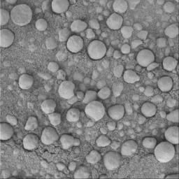
C'est vrai que lorsque l'on voit cette dernière image, on peut comprendre l'étonnement des scientifiques de la NASA devant ces petites spéres ..... qui apporteront la preuve de leur dépot par de l'eau


__________________


Signaler ce message à un modérateur | IP: Logguée
Temps en ligne : 25 Jours, 5 Heures, 18 Minutes, 53 Secondes en ligne

Old Post 26-03-2004 04:20
Cliquez ici pour voir le profil de Solacin Cliquez ici pour lui envoyer un message privé  Trouver plus de messages de Solacin Ajouter Solacin à votre liste d'amis       Editer/Effacer le Message Citer le message dans la réponse
 shakes808080  Rechercher tous les messages de ce membre Cliquez ici pour envoyer un message privé à cet utilisateur
Guru

Déconnecté

Niveau : 5
N° de Membre : 517

Ancienneté : 100%
Participation : 11%
Inscription: 08 Mar 2002
Localisation:
Messages: 8978
Sujets Lancés : 354

d'abord, seth pour ton suivi... je viens régulierement lire ce topic..


__________________
Racket logiciel


Signaler ce message à un modérateur | IP: Logguée
Temps en ligne : 45 Jours, 5 Heures, 55 Minutes, 7 Secondes en ligne

Old Post 26-03-2004 12:03
Cliquez ici pour voir le profil de shakes808080 Cliquez ici pour lui envoyer un message privé  Trouver plus de messages de shakes808080 Ajouter shakes808080 à votre liste d'amis Editer/Effacer le Message Citer le message dans la réponse
 Seth  Rechercher tous les messages de ce membre Cliquez ici pour envoyer un message privé à cet utilisateur
Confirmé

Déconnecté

Niveau : 3
N° de Membre : 1512

Ancienneté : 100%
Participation : 2%
Inscription: 07 May 2002
Localisation:
Messages: 1390
Sujets Lancés : 70


http://photojournal.jpl.nasa.gov/jp...5635_modest.jpg


Citation:

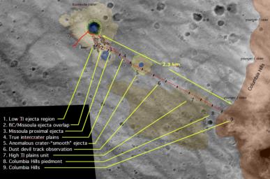
http://photojournal.jpl.nasa.gov/fi...A05635_fig1.jpg
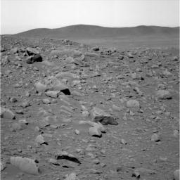
This image shows the rocky road the Mars Exploration Rover Spirit will travel to reach its ultimate destination - the Columbia Hills. The hills, seen here in the background, are located 2.3 kilometers (1.4 miles) away in the southeast direction. Rover planners estimate the journey will take about two months, or 60 sols, including stops at interesting targets along the way. As of sol 81 (March 26, 2004), Spirit has traveled 492 meters (1614 feet).


Signaler ce message à un modérateur | IP: Logguée
Temps en ligne : 8 Jours, 15 Heures, 44 Minutes, 21 Secondes en ligne

Old Post 26-03-2004 23:52
Cliquez ici pour voir le profil de Seth Cliquez ici pour lui envoyer un message privé  Trouver plus de messages de Seth Ajouter Seth à votre liste d'amis Editer/Effacer le Message Citer le message dans la réponse
 Seth  Rechercher tous les messages de ce membre Cliquez ici pour envoyer un message privé à cet utilisateur
Confirmé

Déconnecté

Niveau : 3
N° de Membre : 1512

Ancienneté : 100%
Participation : 2%
Inscription: 07 May 2002
Localisation:
Messages: 1390
Sujets Lancés : 70


http://photojournal.jpl.nasa.gov/jp...5636_modest.jpg

Citation:
This image shows the Mars Exploration Rover Opportunity's view on its 56th sol on Mars, before it left its landing-site crater. To the right, the rover tracks are visible at the original spot where the rover attempted unsuccessfully to exit the crater. After a one-sol delay, Opportunity took another route to the plains of Meridiani Planum. This image was taken by the rover's navigation camera.


Signaler ce message à un modérateur | IP: Logguée
Temps en ligne : 8 Jours, 15 Heures, 44 Minutes, 21 Secondes en ligne

Old Post 26-03-2004 23:53
Cliquez ici pour voir le profil de Seth Cliquez ici pour lui envoyer un message privé  Trouver plus de messages de Seth Ajouter Seth à votre liste d'amis Editer/Effacer le Message Citer le message dans la réponse
 Seth  Rechercher tous les messages de ce membre Cliquez ici pour envoyer un message privé à cet utilisateur
Confirmé

Déconnecté

Niveau : 3
N° de Membre : 1512

Ancienneté : 100%
Participation : 2%
Inscription: 07 May 2002
Localisation:
Messages: 1390
Sujets Lancés : 70


http://photojournal.jpl.nasa.gov/jp...5638_modest.jpg
PIA05638.tif (756.6 kB) http://photojournal.jpl.nasa.gov/tiff/PIA05638.tif

Citation:
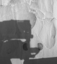
This hazard-avoidance camera image was taken by NASA's Mars Exploration Rover Spirit on sol 79 after completing a two-location brushing on the rock dubbed "Mazatzal." A coating of fine, dust-like material was successfully removed from targets named "Illinois" (right) and "New York" (left), revealing clean rock underneath. In this image, Spirit's panoramic camera mast assembly, or camera head, can be seen shadowing Mazatzal's surface. The center of the two brushed spots are approximately 10 centimeters (3.9 inches) apart and were aggressively analyzed by the instruments on the robotic arm on sol 80. On sol 81, the rover drilled into the New York target to expose the original rock underneath.


Signaler ce message à un modérateur | IP: Logguée
Temps en ligne : 8 Jours, 15 Heures, 44 Minutes, 21 Secondes en ligne

Old Post 26-03-2004 23:54
Cliquez ici pour voir le profil de Seth Cliquez ici pour lui envoyer un message privé  Trouver plus de messages de Seth Ajouter Seth à votre liste d'amis Editer/Effacer le Message Citer le message dans la réponse
 Seth  Rechercher tous les messages de ce membre Cliquez ici pour envoyer un message privé à cet utilisateur
Confirmé

Déconnecté

Niveau : 3
N° de Membre : 1512

Ancienneté : 100%
Participation : 2%
Inscription: 07 May 2002
Localisation:
Messages: 1390
Sujets Lancés : 70


http://photojournal.jpl.nasa.gov/jp...5639_modest.jpg
PIA05639.tif (1.293 MB) http://photojournal.jpl.nasa.gov/tiff/PIA05639.tif

Citation:
This map shows the Mars Exploration Rover Spirit's past and future routes across the Gusev Crater floor. The solid red line shows where the rover has traveled so far, from lander to the rim of the large crater dubbed "Bonneville." The dotted red line indicates proposed future paths to the Columbia Hills. Rover team members have not yet decided which direction Spirit will travel across Bonneville's ejecta (the blanket of material expelled from it during formation) and toward the hills, as illustrated by the two diverging dotted lines. Along the way, Spirit will stop to investigate interesting targets, including craters and plain deposits. The journey to the hills is estimated to about two months, or 60 sols. The underlying image in this map was taken by the camera on NASA's Mars Global Surveyor orbiter.


Signaler ce message à un modérateur | IP: Logguée
Temps en ligne : 8 Jours, 15 Heures, 44 Minutes, 21 Secondes en ligne

Old Post 26-03-2004 23:57
Cliquez ici pour voir le profil de Seth Cliquez ici pour lui envoyer un message privé  Trouver plus de messages de Seth Ajouter Seth à votre liste d'amis Editer/Effacer le Message Citer le message dans la réponse
 Seth  Rechercher tous les messages de ce membre Cliquez ici pour envoyer un message privé à cet utilisateur
Confirmé

Déconnecté

Niveau : 3
N° de Membre : 1512

Ancienneté : 100%
Participation : 2%
Inscription: 07 May 2002
Localisation:
Messages: 1390
Sujets Lancés : 70


http://photojournal.jpl.nasa.gov/jp...5640_modest.jpg

Citation:
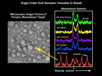
This figure shows spectra, or light signatures, taken by the Mars Exploration Rover Opportunity's Moessbauer spectrometer at various spots in "Eagle Crater." From top to bottom, the spectra represent soil measurements taken from the center of the crater and out to the rim. The top spectrum taken on sol 56 near the center of the crater shows a basaltic mineral composition and only minor amounts of hematite. Basalts are volcanic minerals and hematite is an iron-bearing mineral often formed in water. Moving closer to the rim, the spectra show increasing amounts of hematite with the "Punaluu" site containing the highest amounts seen to date on Mars. Only minor basaltic components are seen in this sample.
The corresponding microscopic image of Punaluu shows a high density of "blueberries," indicating that these sphere-like grains are responsible for the observed high levels of hematite.


Signaler ce message à un modérateur | IP: Logguée
Temps en ligne : 8 Jours, 15 Heures, 44 Minutes, 21 Secondes en ligne

Old Post 26-03-2004 23:58
Cliquez ici pour voir le profil de Seth Cliquez ici pour lui envoyer un message privé  Trouver plus de messages de Seth Ajouter Seth à votre liste d'amis Editer/Effacer le Message Citer le message dans la réponse
 Seth  Rechercher tous les messages de ce membre Cliquez ici pour envoyer un message privé à cet utilisateur
Confirmé

Déconnecté

Niveau : 3
N° de Membre : 1512

Ancienneté : 100%
Participation : 2%
Inscription: 07 May 2002
Localisation:
Messages: 1390
Sujets Lancés : 70


http://photojournal.jpl.nasa.gov/jp...5645_modest.jpg
PIA05645.tif (1.218 MB) http://photojournal.jpl.nasa.gov/tiff/PIA05645.tif

Citation:
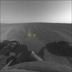
This image from the Mars Exploration Rover Opportunity's front hazard-avoidance camera focuses on a target called "Goal 5." Goal 5, examined during the "Eagle Crater" soil survey, is a wind-rippled spot on the upper part of the crater , which the miniature thermal emission spectrometer shows is higher in hematite content compared to other soils within the crater. The light soil in the center of the image is referred to as "Lanikai" - an inspiration from the white sand beaches of Hawaii. The dark soil is referred to as "Punaluu" after the black sand Hawaiian beaches.


Signaler ce message à un modérateur | IP: Logguée
Temps en ligne : 8 Jours, 15 Heures, 44 Minutes, 21 Secondes en ligne

Old Post 27-03-2004 22:21
Cliquez ici pour voir le profil de Seth Cliquez ici pour lui envoyer un message privé  Trouver plus de messages de Seth Ajouter Seth à votre liste d'amis Editer/Effacer le Message Citer le message dans la réponse
 Seth  Rechercher tous les messages de ce membre Cliquez ici pour envoyer un message privé à cet utilisateur
Confirmé

Déconnecté

Niveau : 3
N° de Membre : 1512

Ancienneté : 100%
Participation : 2%
Inscription: 07 May 2002
Localisation:
Messages: 1390
Sujets Lancés : 70


http://photojournal.jpl.nasa.gov/jp...5646_modest.jpg
PIA05646.tif (1.05 MB) http://photojournal.jpl.nasa.gov/tiff/PIA05646.tif

Citation:
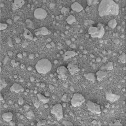
This three-centimeter by three-centimeter (1.2-inch by 1.2-inch) microscopic image of the soil survey target informally called "Lanikai" was taken on the Mars Exploration Rover Opportunity's 52nd sol, or day, on Mars. Named after Hawaii's white sand beaches, this target reveals irregularly shaped, light-colored, millimeter-sized (0.04 inch) clasts, or particles, in a fine-grained soil. Lanikai's angular, less-rounded clast shapes interested the science team when compared to other soil targets in the crater area examined by the microscopic imager.


Signaler ce message à un modérateur | IP: Logguée
Temps en ligne : 8 Jours, 15 Heures, 44 Minutes, 21 Secondes en ligne

Old Post 27-03-2004 22:22
Cliquez ici pour voir le profil de Seth Cliquez ici pour lui envoyer un message privé  Trouver plus de messages de Seth Ajouter Seth à votre liste d'amis Editer/Effacer le Message Citer le message dans la réponse
 Seth  Rechercher tous les messages de ce membre Cliquez ici pour envoyer un message privé à cet utilisateur
Confirmé

Déconnecté

Niveau : 3
N° de Membre : 1512

Ancienneté : 100%
Participation : 2%
Inscription: 07 May 2002
Localisation:
Messages: 1390
Sujets Lancés : 70


http://photojournal.jpl.nasa.gov/jp...5647_modest.jpg
PIA05647.tif (1.05 MB) http://photojournal.jpl.nasa.gov/tiff/PIA05647.tif

Citation:
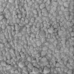
This three-centimeter by three-centimeter (1.2-inch by 1.2-inch) image of the soil target, informally called "Punaluu" after the black sand beaches of Hawaii, was taken by the Mars Exploration Rover Opportunity's microscopic imager during the rover's "Eagle Crater" soil survey. The largest particles are similar to those seen in the crater outcrop. There are also some smaller, more irregular rounded particles that have likely been transported by wind. The Moessbauer spectrometer's study of this target pushed some of the particles into the surrounding fine-grained sand.


Signaler ce message à un modérateur | IP: Logguée
Temps en ligne : 8 Jours, 15 Heures, 44 Minutes, 21 Secondes en ligne

Old Post 27-03-2004 22:23
Cliquez ici pour voir le profil de Seth Cliquez ici pour lui envoyer un message privé  Trouver plus de messages de Seth Ajouter Seth à votre liste d'amis Editer/Effacer le Message Citer le message dans la réponse
 Seth  Rechercher tous les messages de ce membre Cliquez ici pour envoyer un message privé à cet utilisateur
Confirmé

Déconnecté

Niveau : 3
N° de Membre : 1512

Ancienneté : 100%
Participation : 2%
Inscription: 07 May 2002
Localisation:
Messages: 1390
Sujets Lancés : 70


http://photojournal.jpl.nasa.gov/jp...5648_modest.jpg
PIA05648.tif (300.4 kB) http://photojournal.jpl.nasa.gov/tiff/PIA05648.tif

Citation:

http://photojournal.jpl.nasa.gov/fi...A05648_fig1.jpg

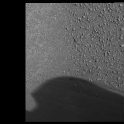
This panoramic camera image of the soil target whimsically called "Neopolitan" from the Mars Exploration Rover Opportunity's "Eagle Crater" soil survey highlights the border between two different soil types - a lighter, finer-grained unit to the left and a darker, coarser-grained to the right. Scientists are pondering the unusually distinct border between these different soil types. To the lower left and partially hidden by the shadow of the mast is an airbag bounce mark.


Signaler ce message à un modérateur | IP: Logguée
Temps en ligne : 8 Jours, 15 Heures, 44 Minutes, 21 Secondes en ligne

Old Post 27-03-2004 22:25
Cliquez ici pour voir le profil de Seth Cliquez ici pour lui envoyer un message privé  Trouver plus de messages de Seth Ajouter Seth à votre liste d'amis Editer/Effacer le Message Citer le message dans la réponse
 Seth  Rechercher tous les messages de ce membre Cliquez ici pour envoyer un message privé à cet utilisateur
Confirmé

Déconnecté

Niveau : 3
N° de Membre : 1512

Ancienneté : 100%
Participation : 2%
Inscription: 07 May 2002
Localisation:
Messages: 1390
Sujets Lancés : 70


http://photojournal.jpl.nasa.gov/jp...5649_modest.jpg
PIA05649.tif (1.05 MB) http://photojournal.jpl.nasa.gov/tiff/PIA05649.tif

Citation:
This three-centimeter by three-centimeter (1.2-inch by 1.2-inch) microscopic image from the Mars Exploration Rover Opportunity's "Eagle Crater" soil survey displays a mixture of light and dark soil units at the target called "Cookies and Cream" in the "Neopolitan" area. There are several different types of clasts, or particles, held in surrounding fine-grained sands: rounded spherules, angular, irregular fragments (containing what are presumably vesicles or small cavities) and small, rounded clasts about one millimeter (.04 inch) in size.


Signaler ce message à un modérateur | IP: Logguée
Temps en ligne : 8 Jours, 15 Heures, 44 Minutes, 21 Secondes en ligne

Old Post 27-03-2004 22:26
Cliquez ici pour voir le profil de Seth Cliquez ici pour lui envoyer un message privé  Trouver plus de messages de Seth Ajouter Seth à votre liste d'amis Editer/Effacer le Message Citer le message dans la réponse
 Seth  Rechercher tous les messages de ce membre Cliquez ici pour envoyer un message privé à cet utilisateur
Confirmé

Déconnecté

Niveau : 3
N° de Membre : 1512

Ancienneté : 100%
Participation : 2%
Inscription: 07 May 2002
Localisation:
Messages: 1390
Sujets Lancés : 70


http://photojournal.jpl.nasa.gov/jp...5650_modest.jpg
PIA05650.tif (1.014 MB) http://photojournal.jpl.nasa.gov/tiff/PIA05650.tif

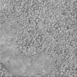
[IMG]Part of the "Eagle Crater" soil survey, this three-centimeter by three-centimeter (1.2-inch by 1.2-inch) microscopic image of the target called "Vanilla" within the "Neopolitan" area was taken on the Mars Exploration Rover Opportunity's 53rd sol, or day, on Mars. The image features small grains one millimeter (0.04 inch) or less in size and somewhat lighter in color than those in other soil units observed in the crater. Before this picture was taken, the rover's Moessbauer spectrometer took measurements of the target and pressed some of the grains into the surrounding finer-grained soil.[/IMG]


Signaler ce message à un modérateur | IP: Logguée
Temps en ligne : 8 Jours, 15 Heures, 44 Minutes, 21 Secondes en ligne

Old Post 27-03-2004 22:27
Cliquez ici pour voir le profil de Seth Cliquez ici pour lui envoyer un message privé  Trouver plus de messages de Seth Ajouter Seth à votre liste d'amis Editer/Effacer le Message Citer le message dans la réponse
 Seth  Rechercher tous les messages de ce membre Cliquez ici pour envoyer un message privé à cet utilisateur
Confirmé

Déconnecté

Niveau : 3
N° de Membre : 1512

Ancienneté : 100%
Participation : 2%
Inscription: 07 May 2002
Localisation:
Messages: 1390
Sujets Lancés : 70


http://photojournal.jpl.nasa.gov/jp...5651_modest.jpg
PIA05651.tif (12.77 MB) http://photojournal.jpl.nasa.gov/tiff/PIA05651.tif

Citation:
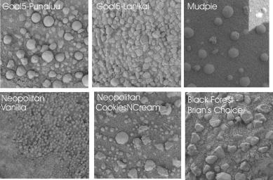
This mosaic of microscopic images (each about two centimeters by two centimeters or .8 inches by .8 inches) from the Mars Exploration Rover Opportunity illustrates the tremendous variety of soil types and shapes observed by the science team during the recent "Eagle Crater" five-target soil survey. Scientists are working to understand the sorting mechanisms that have distributed the various soil types. The survey was conducted from sol 52 to sol 56.
"Punaluu's" largest particles are similar to those seen in the "Eagle Crater" outcrop (see also PIA05640). There are also some smaller, more irregular rounded particles that have likely been transported by wind. The "Lanikai" target reveals irregularly shaped, light-colored, millimeter-sized (0.04 inch-sized) clasts, or particles, in a fine-grained soil (see also PIA05646). Lanikai's angular, less-rounded clast shapes interested the science team when compared to other soil targets in the crater area studied by the microscopic imager. The image of "Neopolitan" highlights the border between two different soil types - a lighter, finer-grained unit to the left and a darker, coarser-grained to the right (see also PIA05648). Scientists are pondering the unusually distinct border between these different soil types. "Cookies and Cream" (see also PIA05649)is a mixture of light and dark soil units in the "Neopolitan" area. There are several different types of clasts, or particles, held in surrounding fine-grained sands: rounded spherules, angular, irregular fragments (containing what are presumably vesicles or small cavities) and smaller, about one millimeter-sized (0.04 inch-sized), rounded clasts. At "Vanilla," the microscopic images have revealed small grains one millimeter (0.04 inch) or less in size and somewhat lighter in color than those in other soil units observed in the crater (see also PIA05650). "Mudpie" is representative of the soils lower in the crater, a fair distance from the outcrop. It contains spherules and irregularly shaped vesicles held in a dark sand. In the "Black Forest" area at the target referred to as "Brian's Choice" are irregularly shaped clasts, low in hematite content based on miniature thermal emission spectrometer readings. Presumably, the particles in this area are more affected by winds since they are on the outer part of crater and are likely deposited and re-distributed by wind on a fairly frequent basis.


Signaler ce message à un modérateur | IP: Logguée
Temps en ligne : 8 Jours, 15 Heures, 44 Minutes, 21 Secondes en ligne

Old Post 27-03-2004 22:28
Cliquez ici pour voir le profil de Seth Cliquez ici pour lui envoyer un message privé  Trouver plus de messages de Seth Ajouter Seth à votre liste d'amis Editer/Effacer le Message Citer le message dans la réponse
 Solacin  Rechercher tous les messages de ce membre Cliquez ici pour envoyer un message privé à cet utilisateur
Guru

Déconnecté

Niveau : 5
N° de Membre : 11117

Ancienneté : 96%
Participation : 10%
Inscription: 23 Mar 2003
Localisation: 974
Age: 52
Messages: 8253
Sujets Lancés : 28

Mignonne comme tout cette mosaïque !!!!


__________________


Signaler ce message à un modérateur | IP: Logguée
Temps en ligne : 25 Jours, 5 Heures, 18 Minutes, 53 Secondes en ligne

Old Post 29-03-2004 10:03
Cliquez ici pour voir le profil de Solacin Cliquez ici pour lui envoyer un message privé  Trouver plus de messages de Solacin Ajouter Solacin à votre liste d'amis       Editer/Effacer le Message Citer le message dans la réponse
Il est actuellement 13:45 (GMT) Poster un nouveau sujet    Poster une réponse   
Page(s) (49): [ <<   <   24   25   26   27   28   29   30   31   32   33   34   35   36   37   38   39   40   41   42   >   >> ]  Sujet précédent   Sujet suivant
Forum OXMO > Section Généraliste > Discussion Libre > Je vous parle en direct de Mars (Opportunity a atterri !)

Aller au Forum:
Notez ce sujet :


 Réponse Rapide
Titre: (Optionnel)
Message:

Convertir automatiquement les URLs Montrer la Signature
Afficher une version imprimable | Envoyer cette page par email | S'inscrire à ce sujet | Télécharger ce sujet
Règles du forum :
Créer de nouveaux sujets
Répondre aux messages
Attacher des fichiers
Editer vos messages
: not autorisé
: not autorisé
: not autorisé
: not autorisé
Le Code HTML est OFF
Le Code vB est ON
Les Smileys sont ONs
Le code [IMG] est ON
 
< Contactez-nous - Forum OXMO>

Uptime du serveur SQL : 2 jour(s) 13 heure(s) et 21 minute(s)
Page générée en 0.013217 secondes en exécutant 42 requêtes SQL.
Apache - Compression GZIP : Activée.