Accueil Foire Aux Questions Trouver d'autres membres Rechercher Utilisez le vBpad pour stocker des notes personnelles Ici, vous pouvez voir les sujets auxquels vous avez souscris, vos messages privés; et modifier vos informations personnelles et préférences. Statistiques du forum Enregistrez vous gratuitement ! Se déconnecter  
Forum OXMO Forum OXMO > Section Généraliste > Discussion Libre > Je vous parle en direct de Mars (Opportunity a atterri !)


Aller au Forum:
Notez ce sujet :

Page(s) (49): [ <<   <   26   27   28   29   30   31   32   33   34   35   36   37   38   39   40   41   42   43   44   >   >> ]   Sujet précédent   Sujet suivant
Auteur
Sujet Poster un nouveau sujet    Poster une réponse
 Seth  Rechercher tous les messages de ce membre Cliquez ici pour envoyer un message privé à cet utilisateur
Confirmé

Déconnecté

Niveau : 3
N° de Membre : 1512

Ancienneté : 100%
Participation : 2%
Inscription: 07 May 2002
Localisation:
Messages: 1390
Sujets Lancés : 70

Citation:
Message écrit par Solacin, le 01-04-2004 à 14:40
Ben ça, c'est une bien belle photo de forage hein !!!!!!! sisisi


ils n'ont rien d'autre


Signaler ce message à un modérateur | IP: Logguée
Temps en ligne : 8 Jours, 15 Heures, 44 Minutes, 21 Secondes en ligne

Old Post 01-04-2004 05:54
Cliquez ici pour voir le profil de Seth Cliquez ici pour lui envoyer un message privé  Trouver plus de messages de Seth Ajouter Seth à votre liste d'amis Editer/Effacer le Message Citer le message dans la réponse
 Solacin  Rechercher tous les messages de ce membre Cliquez ici pour envoyer un message privé à cet utilisateur
Guru

Déconnecté

Niveau : 5
N° de Membre : 11117

Ancienneté : 96%
Participation : 10%
Inscription: 23 Mar 2003
Localisation: 974
Age: 52
Messages: 8253
Sujets Lancés : 28

Merde alors !!!! moi j'veux du panorama, de la couleur, de la vision 3D ..... pas des trous de forages


__________________


Signaler ce message à un modérateur | IP: Logguée
Temps en ligne : 25 Jours, 5 Heures, 18 Minutes, 53 Secondes en ligne

Old Post 01-04-2004 06:41
Cliquez ici pour voir le profil de Solacin Cliquez ici pour lui envoyer un message privé  Trouver plus de messages de Solacin Ajouter Solacin à votre liste d'amis       Editer/Effacer le Message Citer le message dans la réponse
 Seth  Rechercher tous les messages de ce membre Cliquez ici pour envoyer un message privé à cet utilisateur
Confirmé

Déconnecté

Niveau : 3
N° de Membre : 1512

Ancienneté : 100%
Participation : 2%
Inscription: 07 May 2002
Localisation:
Messages: 1390
Sujets Lancés : 70

Citation:
Message écrit par Solacin, le 01-04-2004 à 15:41
Merde alors !!!! moi j'veux du panorama, de la couleur, de la vision 3D ..... pas des trous de forages


I understand this
What the telephone number for NASA?


Signaler ce message à un modérateur | IP: Logguée
Temps en ligne : 8 Jours, 15 Heures, 44 Minutes, 21 Secondes en ligne

Old Post 01-04-2004 08:27
Cliquez ici pour voir le profil de Seth Cliquez ici pour lui envoyer un message privé  Trouver plus de messages de Seth Ajouter Seth à votre liste d'amis Editer/Effacer le Message Citer le message dans la réponse
 Solacin  Rechercher tous les messages de ce membre Cliquez ici pour envoyer un message privé à cet utilisateur
Guru

Déconnecté

Niveau : 5
N° de Membre : 11117

Ancienneté : 96%
Participation : 10%
Inscription: 23 Mar 2003
Localisation: 974
Age: 52
Messages: 8253
Sujets Lancés : 28

Hihihihi, why not !!!!!!


__________________


Signaler ce message à un modérateur | IP: Logguée
Temps en ligne : 25 Jours, 5 Heures, 18 Minutes, 53 Secondes en ligne

Old Post 01-04-2004 08:34
Cliquez ici pour voir le profil de Solacin Cliquez ici pour lui envoyer un message privé  Trouver plus de messages de Solacin Ajouter Solacin à votre liste d'amis       Editer/Effacer le Message Citer le message dans la réponse
 Seth  Rechercher tous les messages de ce membre Cliquez ici pour envoyer un message privé à cet utilisateur
Confirmé

Déconnecté

Niveau : 3
N° de Membre : 1512

Ancienneté : 100%
Participation : 2%
Inscription: 07 May 2002
Localisation:
Messages: 1390
Sujets Lancés : 70


http://photojournal.jpl.nasa.gov/jp...5666_modest.jpg
PIA05666.tif (3.294 MB) http://photojournal.jpl.nasa.gov/tiff/PIA05666.t


Citation:
Released 1 April 2004
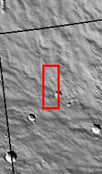
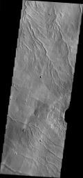
The Odyssey spacecraft has completed a full Mars year of observations of the red planet. For the next several weeks the Image of the Day will look back over this first mars year. It will focus on four themes: 1) the poles - with the seasonal changes seen in the retreat and expansion of the caps; 2) craters - with a variety of morphologies relating to impact materials and later alteration, both infilling and exhumation; 3) channels - the clues to liquid surface flow; and 4) volcanic flow features. While some images have helped answer questions about the history of Mars, many have raised new questions that are still being investigated as Odyssey continues collecting data as it orbits Mars.

The channel shown on the image is near the feature called Alba Patera. It was collected August 22, 2002 during northern spring season. The local time is 4:30pm. The image shows multiple possibly liquid formed channels.

Image information: VIS instrument. Latitude 43.7, Longitude 241.5 East (118.5 West). 19 meter/pixel resolution.

Note: this THEMIS visual image has not been radiometrically nor geometrically calibrated for this preliminary release. An empirical correction has been performed to remove instrumental effects. A linear shift has been applied in the cross-track and down-track direction to approximate spacecraft and planetary motion. Fully calibrated and geometrically projected images will be released through the Planetary Data System in accordance with Project policies at a later time.

NASA's Jet Propulsion Laboratory manages the 2001 Mars Odyssey mission for NASA's Office of Space Science, Washington, D.C. The Thermal Emission Imaging System (THEMIS) was developed by Arizona State University, Tempe, in collaboration with Raytheon Santa Barbara Remote Sensing. The THEMIS investigation is led by Dr. Philip Christensen at Arizona State University. Lockheed Martin Astronautics, Denver, is the prime contractor for the Odyssey project, and developed and built the orbiter. Mission operations are conducted jointly from Lockheed Martin and from JPL, a division of the California Institute of Technology in Pasadena.


Signaler ce message à un modérateur | IP: Logguée
Temps en ligne : 8 Jours, 15 Heures, 44 Minutes, 21 Secondes en ligne

Old Post 02-04-2004 01:12
Cliquez ici pour voir le profil de Seth Cliquez ici pour lui envoyer un message privé  Trouver plus de messages de Seth Ajouter Seth à votre liste d'amis Editer/Effacer le Message Citer le message dans la réponse
 Seth  Rechercher tous les messages de ce membre Cliquez ici pour envoyer un message privé à cet utilisateur
Confirmé

Déconnecté

Niveau : 3
N° de Membre : 1512

Ancienneté : 100%
Participation : 2%
Inscription: 07 May 2002
Localisation:
Messages: 1390
Sujets Lancés : 70


http://photojournal.jpl.nasa.gov/jp...5667_modest.jpg
PIA05667.tif (388.9 kB) http://photojournal.jpl.nasa.gov/tiff/PIA05667.tif

Citation:
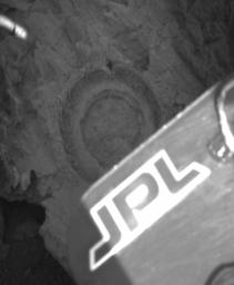
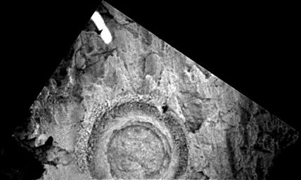
This panoramic camera image from the Mars Exploration Rover Opportunity features the 6.44 millimeter (0.25 inch) deep hole ground into the rock dubbed "Bounce" by the rover's rock abrasion tool. The tool took 2 hours and 15 minutes to grind the hole on sol 66 of the rover's journey. A combination of limited solar power and the rock's jagged texture led the rock abrasion tool team to set very aggressive grinding parameters to ensure that the end result was a full circle, suitable for a thorough read from the rover's spectrometers.
Bounce's markedly different appearance (when compared to the rocks that were previously examined in the Eagle Crater outcrop) made it a natural target for rover research. In order to achieve an ideal position from which to grind into the rock, Opportunity moved in very close with its right wheel next to Bounce. In this image, the panoramic camera on the rover's mast is looking down, catching the tip of the solar panel which partially blocks the full circle ground by the rock abrasion tool.

The outer ring consists of the cuttings from the rock, pushed out by the brushes on the grinding instrument. The dark impression at the top of the outer circle was caused by the instrument's contact mechanism which serves to stabilize it while grinding.


Signaler ce message à un modérateur | IP: Logguée
Temps en ligne : 8 Jours, 15 Heures, 44 Minutes, 21 Secondes en ligne

Old Post 02-04-2004 01:13
Cliquez ici pour voir le profil de Seth Cliquez ici pour lui envoyer un message privé  Trouver plus de messages de Seth Ajouter Seth à votre liste d'amis Editer/Effacer le Message Citer le message dans la réponse
 Seth  Rechercher tous les messages de ce membre Cliquez ici pour envoyer un message privé à cet utilisateur
Confirmé

Déconnecté

Niveau : 3
N° de Membre : 1512

Ancienneté : 100%
Participation : 2%
Inscription: 07 May 2002
Localisation:
Messages: 1390
Sujets Lancés : 70


http://photojournal.jpl.nasa.gov/jp...5668_modest.jpg
PIA05668.tif (668.4 kB) http://photojournal.jpl.nasa.gov/tiff/PIA05668.tif

Citation:
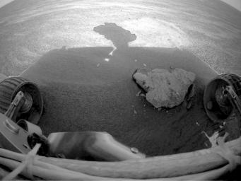
This image from the Mars Exploration Rover Opportunity front left hazard-avoidance camera shows a pebble caught in rover's front right wheel. The image from sol 63 of the mission was taken as the rover approached the rock dubbed "Bounce" for analysis.


Signaler ce message à un modérateur | IP: Logguée
Temps en ligne : 8 Jours, 15 Heures, 44 Minutes, 21 Secondes en ligne

Old Post 02-04-2004 01:15
Cliquez ici pour voir le profil de Seth Cliquez ici pour lui envoyer un message privé  Trouver plus de messages de Seth Ajouter Seth à votre liste d'amis Editer/Effacer le Message Citer le message dans la réponse
 Seth  Rechercher tous les messages de ce membre Cliquez ici pour envoyer un message privé à cet utilisateur
Confirmé

Déconnecté

Niveau : 3
N° de Membre : 1512

Ancienneté : 100%
Participation : 2%
Inscription: 07 May 2002
Localisation:
Messages: 1390
Sujets Lancés : 70


http://photojournal.jpl.nasa.gov/jp...5669_modest.jpg
PIA05669.tif (1.644 MB) http://photojournal.jpl.nasa.gov/tiff/PIA05669.tif

Citation:
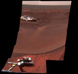
This mosaic of images from the Mars Exploration Rover Opportunity panoramic camera looks to the southeast from inside Eagle Crater. This was among the first peeks out into the plains, revealing the enigmatic dark feature dubbed "Bounce" rock, seen on the left side of the mosaic. This feature is right next to one of the large bounce marks that the airbag-packaged rover made as it was bouncing across the plains during landing. This enhanced color mosaic was made on sol 36 from the camera's the infrared (750 nanometer), green (530 nanometer), and violet (430 nanometer) filters.


(I had to phone NASA to have this color picture ^O^)


Signaler ce message à un modérateur | IP: Logguée
Temps en ligne : 8 Jours, 15 Heures, 44 Minutes, 21 Secondes en ligne

Old Post 02-04-2004 01:17
Cliquez ici pour voir le profil de Seth Cliquez ici pour lui envoyer un message privé  Trouver plus de messages de Seth Ajouter Seth à votre liste d'amis Editer/Effacer le Message Citer le message dans la réponse
 Seth  Rechercher tous les messages de ce membre Cliquez ici pour envoyer un message privé à cet utilisateur
Confirmé

Déconnecté

Niveau : 3
N° de Membre : 1512

Ancienneté : 100%
Participation : 2%
Inscription: 07 May 2002
Localisation:
Messages: 1390
Sujets Lancés : 70


http://photojournal.jpl.nasa.gov/jp...5670_modest.jpg
PIA05670.tif (562.7 kB) http://photojournal.jpl.nasa.gov/tiff/PIA05670.tif

Citation:
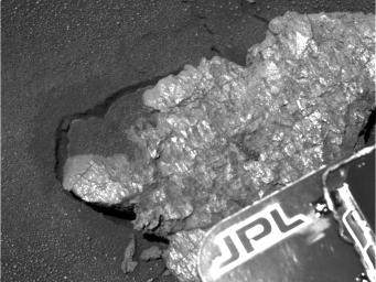
This high-resolution panoramic camera blue filter image of the rock dubbed "Bounce" was obtained up close, just before the rover placed its instruments on the rock for detailed study. The rock has a number of shiny surfaces and textures on it, some of which are unlike those seen in the Eagle Crater rock outcrop. Also, the rock was apparently moved or shaken when it was hit with the airbags, as can be seen by the gap and cracks in the soil around the rock. This image from sol 65 of the rover's journey was acquired using the panoramic camera's 430 nanometer filter.


Signaler ce message à un modérateur | IP: Logguée
Temps en ligne : 8 Jours, 15 Heures, 44 Minutes, 21 Secondes en ligne

Old Post 02-04-2004 01:19
Cliquez ici pour voir le profil de Seth Cliquez ici pour lui envoyer un message privé  Trouver plus de messages de Seth Ajouter Seth à votre liste d'amis Editer/Effacer le Message Citer le message dans la réponse
 Seth  Rechercher tous les messages de ce membre Cliquez ici pour envoyer un message privé à cet utilisateur
Confirmé

Déconnecté

Niveau : 3
N° de Membre : 1512

Ancienneté : 100%
Participation : 2%
Inscription: 07 May 2002
Localisation:
Messages: 1390
Sujets Lancés : 70


http://photojournal.jpl.nasa.gov/jp...5671_modest.jpg
PIA05671.tif (175.6 kB) http://photojournal.jpl.nasa.gov/tiff/PIA05671.tif

Citation:
This panoramic camera image shows the hole drilled by the Mars Exploration Rover Opportunity's rock abrasion tool into the rock dubbed "Bounce" on Sol 65 of the rover's journey. The tool drilled about 7 millimeters (0.3 inches) into the rock and generated small piles of "tailings" or rock dust around the central hole, which is about 4.5 centimeters (1.7 inches) across. The image from sol 66 of the mission was acquired using the panoramic camera's 430 nanometer filter.


Signaler ce message à un modérateur | IP: Logguée
Temps en ligne : 8 Jours, 15 Heures, 44 Minutes, 21 Secondes en ligne

Old Post 02-04-2004 01:20
Cliquez ici pour voir le profil de Seth Cliquez ici pour lui envoyer un message privé  Trouver plus de messages de Seth Ajouter Seth à votre liste d'amis Editer/Effacer le Message Citer le message dans la réponse
 Seth  Rechercher tous les messages de ce membre Cliquez ici pour envoyer un message privé à cet utilisateur
Confirmé

Déconnecté

Niveau : 3
N° de Membre : 1512

Ancienneté : 100%
Participation : 2%
Inscription: 07 May 2002
Localisation:
Messages: 1390
Sujets Lancés : 70


http://photojournal.jpl.nasa.gov/jp...5672_modest.jpg
PIA05672.tif (30.63 MB) http://photojournal.jpl.nasa.gov/tiff/PIA05672.tif

Citation:
This image from the Mars Exploration Rover Opportunity's panoramic camera shows one octant of a larger panoramic image which has not yet been fully processed. The full panorama, dubbed "Lion King" was obtained on sols 58 and 60 of the mission as the rover was perched at the lip of Eagle Crater, majestically looking down into its former home. It is the largest panorama yet obtained by either rover. The octant, which faces directly into the crater, shows features as small as a few millimeters across in the field near the rover arm, to features a few meters across or larger on the horizon.
The full panoramic image was taken in eight segments using six filters per segment, for a total of 558 images and more than 75 megabytes of data. This enhanced color composite was assembled from the infrared (750 nanometer), green (530 nanometer), and violet (430 nanometer) filters. Additional lower elevation tiers were added relative to other panoramas to ensure that the entire crater was covered in the mosaic.


Signaler ce message à un modérateur | IP: Logguée
Temps en ligne : 8 Jours, 15 Heures, 44 Minutes, 21 Secondes en ligne

Old Post 02-04-2004 01:21
Cliquez ici pour voir le profil de Seth Cliquez ici pour lui envoyer un message privé  Trouver plus de messages de Seth Ajouter Seth à votre liste d'amis Editer/Effacer le Message Citer le message dans la réponse
 Seth  Rechercher tous les messages de ce membre Cliquez ici pour envoyer un message privé à cet utilisateur
Confirmé

Déconnecté

Niveau : 3
N° de Membre : 1512

Ancienneté : 100%
Participation : 2%
Inscription: 07 May 2002
Localisation:
Messages: 1390
Sujets Lancés : 70


http://photojournal.jpl.nasa.gov/jp...5673_modest.jpg
PIA05673.tif (948.6 kB) http://photojournal.jpl.nasa.gov/tiff/PIA05673.tif

Citation:
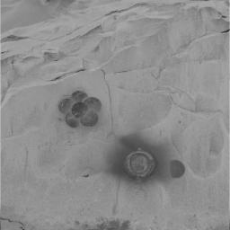
This image from the Mars Exploration Rover Spirit panoramic camera shows a daisy pattern created by the rover's rock abrasion tool on the surface of "Mazatzal." The pattern was made as the rover brushed dust off enough area on the rock to match the field of view of the rover's miniature thermal emission spectrometer instrument.


Signaler ce message à un modérateur | IP: Logguée
Temps en ligne : 8 Jours, 15 Heures, 44 Minutes, 21 Secondes en ligne

Old Post 02-04-2004 01:22
Cliquez ici pour voir le profil de Seth Cliquez ici pour lui envoyer un message privé  Trouver plus de messages de Seth Ajouter Seth à votre liste d'amis Editer/Effacer le Message Citer le message dans la réponse
 Solacin  Rechercher tous les messages de ce membre Cliquez ici pour envoyer un message privé à cet utilisateur
Guru

Déconnecté

Niveau : 5
N° de Membre : 11117

Ancienneté : 96%
Participation : 10%
Inscription: 23 Mar 2003
Localisation: 974
Age: 52
Messages: 8253
Sujets Lancés : 28

Whouahh, je suis gaté dis donc !!!! 2 en couleurs cette fois-ci


__________________


Signaler ce message à un modérateur | IP: Logguée
Temps en ligne : 25 Jours, 5 Heures, 18 Minutes, 53 Secondes en ligne

Old Post 02-04-2004 05:56
Cliquez ici pour voir le profil de Solacin Cliquez ici pour lui envoyer un message privé  Trouver plus de messages de Solacin Ajouter Solacin à votre liste d'amis       Editer/Effacer le Message Citer le message dans la réponse
 Seth  Rechercher tous les messages de ce membre Cliquez ici pour envoyer un message privé à cet utilisateur
Confirmé

Déconnecté

Niveau : 3
N° de Membre : 1512

Ancienneté : 100%
Participation : 2%
Inscription: 07 May 2002
Localisation:
Messages: 1390
Sujets Lancés : 70


http://photojournal.jpl.nasa.gov/jp...5678_modest.jpg
PIA05678.tif (456 kB) http://photojournal.jpl.nasa.gov/tiff/PIA05678.tif


Citation:

http://photojournal.jpl.nasa.gov/fi...A05678_fig1.jpg
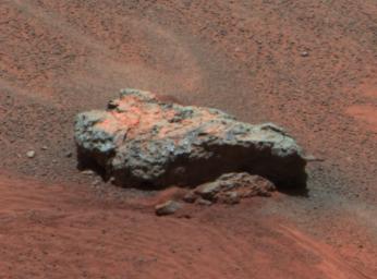
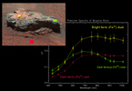
This Mars Exploration Rover Opportunity panoramic camera image shows "Bounce Rock," a rock the airbag-packaged rover struck while rolling to a stop on January 24, 2004. This is the largest rock for as far as the eye can see, approximately 35 centimeters (14 inches) long and 10 centimeters (4 inches) high. There appears to be a dusty coating on the top of parts of the rock, which may have been broken when it was struck by the airbags. The rock was about 5 meters (16 feet) from the rover when this image was obtained. This is an enhanced color composite image from sol 36 of the rover's journey, generated using the camera's L2 (750 nanometer), L5 (530 nanometer), and L6 (480 nanometer) filters.
Bounce Rock Spectra
Figure 1 above is a plot of panoramic camera spectra extracted from three different regions on the rock dubbed "Bounce." The yellow spectrum is from the yellow box in the image on the left, from the dusty top part of the rock. The spectrum is dominated by the signature of oxidized "ferric" iron (Fe3+) like that seen in the classic Martian dust. The red spectrum is from the darker Meridiani Planum soils that were disturbed by the airbag when it bounced near the rock. That spectrum is also dominated by ferric iron, though the reflectivity is lower. Scientists speculate that this may be because the grains are coarser in these soils compared to the dust. The green spectrum, which is from the right side of the rock, shows a strong drop in the infrared reflectance that is unlike any other rock yet seen at Meridiani Planum or Gusev Crater. This spectral signature is typical of un-oxidized "ferrous" iron (Fe2+) in the rock, perhaps related to the presence of volcanic minerals like olivine or pyroxene. The possibility that this may be a basaltic rock that is distinctly different from the rocks seen in the Eagle Crater outcrop is being intensively explored using the rover's other instruments.


Signaler ce message à un modérateur | IP: Logguée
Temps en ligne : 8 Jours, 15 Heures, 44 Minutes, 21 Secondes en ligne

Old Post 03-04-2004 01:57
Cliquez ici pour voir le profil de Seth Cliquez ici pour lui envoyer un message privé  Trouver plus de messages de Seth Ajouter Seth à votre liste d'amis Editer/Effacer le Message Citer le message dans la réponse
 Seth  Rechercher tous les messages de ce membre Cliquez ici pour envoyer un message privé à cet utilisateur
Confirmé

Déconnecté

Niveau : 3
N° de Membre : 1512

Ancienneté : 100%
Participation : 2%
Inscription: 07 May 2002
Localisation:
Messages: 1390
Sujets Lancés : 70


http://photojournal.jpl.nasa.gov/jp...5679_modest.jpg
PIA05679.tif (2.897 MB) http://photojournal.jpl.nasa.gov/tiff/PIA05679.tif

Citation:
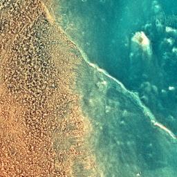
This enhanced-color image taken by the microscopic imager on the Mars Exploration Rover Spirit on sol 79 shows the rock dubbed "Mazatzal" after a portion of its surface was brushed clean by the rover's rock abrasion tool. The reddish material on the right side of the image is the original dust coating. The darker, grayer surface on the left side was exposed after brushing. The crack in the rock may have once contained fluids from which minerals precipitated along its walls. The color in this image was created by combining pictures taken with the microscopic imager's orange-tinted dust cover in both its open and closed positions.


Signaler ce message à un modérateur | IP: Logguée
Temps en ligne : 8 Jours, 15 Heures, 44 Minutes, 21 Secondes en ligne

Old Post 03-04-2004 01:58
Cliquez ici pour voir le profil de Seth Cliquez ici pour lui envoyer un message privé  Trouver plus de messages de Seth Ajouter Seth à votre liste d'amis Editer/Effacer le Message Citer le message dans la réponse
Il est actuellement 12:26 (GMT) Poster un nouveau sujet    Poster une réponse   
Page(s) (49): [ <<   <   26   27   28   29   30   31   32   33   34   35   36   37   38   39   40   41   42   43   44   >   >> ]  Sujet précédent   Sujet suivant
Forum OXMO > Section Généraliste > Discussion Libre > Je vous parle en direct de Mars (Opportunity a atterri !)

Aller au Forum:
Notez ce sujet :


 Réponse Rapide
Titre: (Optionnel)
Message:

Convertir automatiquement les URLs Montrer la Signature
Afficher une version imprimable | Envoyer cette page par email | S'inscrire à ce sujet | Télécharger ce sujet
Règles du forum :
Créer de nouveaux sujets
Répondre aux messages
Attacher des fichiers
Editer vos messages
: not autorisé
: not autorisé
: not autorisé
: not autorisé
Le Code HTML est OFF
Le Code vB est ON
Les Smileys sont ONs
Le code [IMG] est ON
 
< Contactez-nous - Forum OXMO>

Uptime du serveur SQL : 2 jour(s) 12 heure(s) et 2 minute(s)
Page générée en 0.025256 secondes en exécutant 42 requêtes SQL.
Apache - Compression GZIP : Activée.