Accueil Foire Aux Questions Trouver d'autres membres Rechercher Utilisez le vBpad pour stocker des notes personnelles Ici, vous pouvez voir les sujets auxquels vous avez souscris, vos messages privés; et modifier vos informations personnelles et préférences. Statistiques du forum Enregistrez vous gratuitement ! Se déconnecter  
Forum OXMO Forum OXMO > Section Généraliste > Discussion Libre > Je vous parle en direct de Mars (Opportunity a atterri !)


Aller au Forum:
Notez ce sujet :

Page(s) (49): [ <<   <   27   28   29   30   31   32   33   34   35   36   37   38   39   40   41   42   43   44   45   >   >> ]   Sujet précédent   Sujet suivant
Auteur
Sujet Poster un nouveau sujet    Poster une réponse
 Seth  Rechercher tous les messages de ce membre Cliquez ici pour envoyer un message privé à cet utilisateur
Confirmé

Déconnecté

Niveau : 3
N° de Membre : 1512

Ancienneté : 100%
Participation : 2%
Inscription: 07 May 2002
Localisation:
Messages: 1390
Sujets Lancés : 70


http://photojournal.jpl.nasa.gov/jp...5680_modest.jpg
PIA05680.tif (1.258 MB) http://photojournal.jpl.nasa.gov/tiff/PIA05680.tif

Citation:
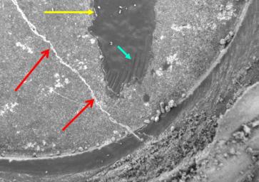
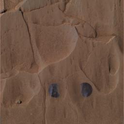
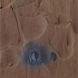
This close-up image taken by the Mars Exploration Rover Spirit's microscopic imager shows a section of the hole drilled into the rock dubbed "Mazatzal" after the hole was ground for a second time. The first drilling by the rover's rock abrasion tool left an incomplete hole, so a second one was performed. The blue arrow points to leftover portions of the dark rind that coats Mazatzal and the scrape marks left by the rock abrasion tool. The yellow arrow highlights the bright edges surrounding the leftover rind. The crack in the rock may have once contained fluids out of which minerals precipitated along its walls (red arrows). Mazatzal is a highly coated rock, containing at least four "cake layers": a top coat of dust, a pinking coating, a dark rind and its true interior. The observed area is 3 centimeters (1.2 inches) across. This image was taken on sol 85.


Signaler ce message à un modérateur | IP: Logguée
Temps en ligne : 8 Jours, 15 Heures, 44 Minutes, 21 Secondes en ligne

Old Post 03-04-2004 02:00
Cliquez ici pour voir le profil de Seth Cliquez ici pour lui envoyer un message privé  Trouver plus de messages de Seth Ajouter Seth à votre liste d'amis Editer/Effacer le Message Citer le message dans la réponse
 Seth  Rechercher tous les messages de ce membre Cliquez ici pour envoyer un message privé à cet utilisateur
Confirmé

Déconnecté

Niveau : 3
N° de Membre : 1512

Ancienneté : 100%
Participation : 2%
Inscription: 07 May 2002
Localisation:
Messages: 1390
Sujets Lancés : 70


http://photojournal.jpl.nasa.gov/jp...5681_modest.jpg
PIA05681.tif (1.53 MB) http://photojournal.jpl.nasa.gov/tiff/PIA05681.tif

Citation:
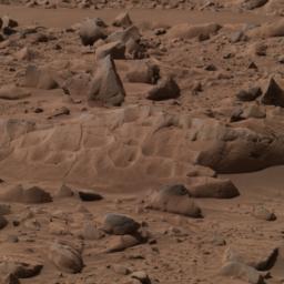
This approximate true-color image taken by the panoramic camera on the Mars Exploration Rover Spirit shows the rock dubbed "Mazatzal" before the rover drilled into it with its rock abrasion tool. On sol 82, Spirit ground into a circular patch of the rock called "New York," then repeated this operation on sol 85 to complete the hole. Several observations were made during this grinding process with the rover's suite of scientific instruments. Preliminary results suggest that fluid may have been present during Mazatzal's formation. Images from the panoramic camera's blue, green and red filters (480, 530 and 600-nanometer filters) were combined to make this picture.


Signaler ce message à un modérateur | IP: Logguée
Temps en ligne : 8 Jours, 15 Heures, 44 Minutes, 21 Secondes en ligne

Old Post 03-04-2004 02:02
Cliquez ici pour voir le profil de Seth Cliquez ici pour lui envoyer un message privé  Trouver plus de messages de Seth Ajouter Seth à votre liste d'amis Editer/Effacer le Message Citer le message dans la réponse
 Seth  Rechercher tous les messages de ce membre Cliquez ici pour envoyer un message privé à cet utilisateur
Confirmé

Déconnecté

Niveau : 3
N° de Membre : 1512

Ancienneté : 100%
Participation : 2%
Inscription: 07 May 2002
Localisation:
Messages: 1390
Sujets Lancés : 70


http://photojournal.jpl.nasa.gov/jp...5682_modest.jpg
PIA05682.tif (2.736 MB) http://photojournal.jpl.nasa.gov/tiff/PIA05682.tif

Citation:
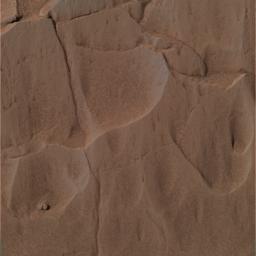
This image was taken by the Mars Exploration Rover Spirit's panoramic camera during the rover's grinding of the rock dubbed "Mazatzal" with its rock abrasion tool. The picture shows the untouched rock on sol 78, which is covered in a light-toned coating and red dust particles. This approximate true-color image was created using the panoramic camera's red, green and blue filters.


Signaler ce message à un modérateur | IP: Logguée
Temps en ligne : 8 Jours, 15 Heures, 44 Minutes, 21 Secondes en ligne

Old Post 03-04-2004 02:06
Cliquez ici pour voir le profil de Seth Cliquez ici pour lui envoyer un message privé  Trouver plus de messages de Seth Ajouter Seth à votre liste d'amis Editer/Effacer le Message Citer le message dans la réponse
 Seth  Rechercher tous les messages de ce membre Cliquez ici pour envoyer un message privé à cet utilisateur
Confirmé

Déconnecté

Niveau : 3
N° de Membre : 1512

Ancienneté : 100%
Participation : 2%
Inscription: 07 May 2002
Localisation:
Messages: 1390
Sujets Lancés : 70


http://photojournal.jpl.nasa.gov/jp...5683_modest.jpg
PIA05683.tif (2.766 MB) http://photojournal.jpl.nasa.gov/tiff/PIA05683.tif

Citation:
This image was taken by the Mars Exploration Rover Spirit's panoramic camera during the rover's grinding of the rock dubbed "Mazatzal" with its rock abrasion tool. The picture shows the rock after two targets dubbed "New York" (left) and "Illinois" were brushed on sol 81. The exposed, dark surface is a second coating beneath a top white veneer. This approximate true-color image was created using the panoramic camera's red, green and blue filters.


Signaler ce message à un modérateur | IP: Logguée
Temps en ligne : 8 Jours, 15 Heures, 44 Minutes, 21 Secondes en ligne

Old Post 03-04-2004 02:07
Cliquez ici pour voir le profil de Seth Cliquez ici pour lui envoyer un message privé  Trouver plus de messages de Seth Ajouter Seth à votre liste d'amis Editer/Effacer le Message Citer le message dans la réponse
 Seth  Rechercher tous les messages de ce membre Cliquez ici pour envoyer un message privé à cet utilisateur
Confirmé

Déconnecté

Niveau : 3
N° de Membre : 1512

Ancienneté : 100%
Participation : 2%
Inscription: 07 May 2002
Localisation:
Messages: 1390
Sujets Lancés : 70


http://photojournal.jpl.nasa.gov/jp...5684_modest.jpg
PIA05684.tif (2.878 MB) http://photojournal.jpl.nasa.gov/tiff/PIA05684.tif

Citation:
This image was taken by the Mars Exploration Rover Spirit's panoramic camera during the rover's grinding of the rock dubbed "Mazatzal" with its rock abrasion tool. The picture shows the rock after the rover drilled 3.8 millimeters (.15 inches) into the target dubbed "New York" on Sol 82. The dark grey coating seen after brushing remains on the right side of the hole, while the left side is the underlying basaltic rock. This approximate true-color image was created using the panoramic camera's red, green and blue filters.


Signaler ce message à un modérateur | IP: Logguée
Temps en ligne : 8 Jours, 15 Heures, 44 Minutes, 21 Secondes en ligne

Old Post 03-04-2004 02:09
Cliquez ici pour voir le profil de Seth Cliquez ici pour lui envoyer un message privé  Trouver plus de messages de Seth Ajouter Seth à votre liste d'amis Editer/Effacer le Message Citer le message dans la réponse
 Seth  Rechercher tous les messages de ce membre Cliquez ici pour envoyer un message privé à cet utilisateur
Confirmé

Déconnecté

Niveau : 3
N° de Membre : 1512

Ancienneté : 100%
Participation : 2%
Inscription: 07 May 2002
Localisation:
Messages: 1390
Sujets Lancés : 70


Animated GIF (1.546 megabytes) http://photojournal.jpl.nasa.gov/archive/PIA05685.gif

Citation:
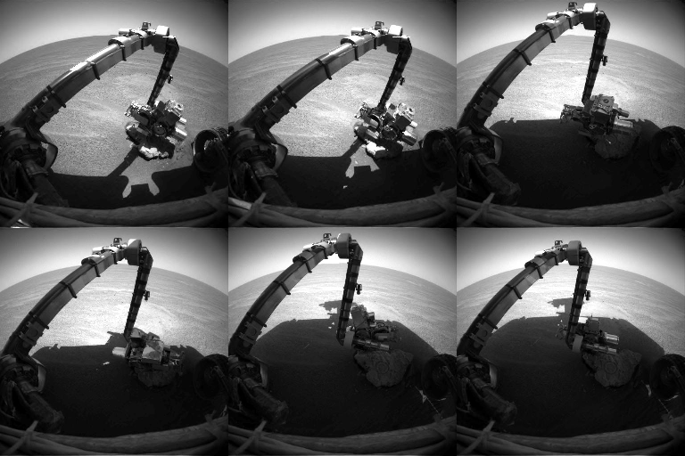
NASA's Opportunity used its robotic arm to examine "Bounce Rock" during the rover's 67th sol on Mars, April 1, 2004. This animation is made up of eight images taken with the front hazard-avoidance camera while the arm, called the instrument deployment device, was in various positions during that sol.


Signaler ce message à un modérateur | IP: Logguée
Temps en ligne : 8 Jours, 15 Heures, 44 Minutes, 21 Secondes en ligne

Old Post 03-04-2004 02:10
Cliquez ici pour voir le profil de Seth Cliquez ici pour lui envoyer un message privé  Trouver plus de messages de Seth Ajouter Seth à votre liste d'amis Editer/Effacer le Message Citer le message dans la réponse
 Seth  Rechercher tous les messages de ce membre Cliquez ici pour envoyer un message privé à cet utilisateur
Confirmé

Déconnecté

Niveau : 3
N° de Membre : 1512

Ancienneté : 100%
Participation : 2%
Inscription: 07 May 2002
Localisation:
Messages: 1390
Sujets Lancés : 70


http://photojournal.jpl.nasa.gov/jp...5686_modest.jpg
PIA05686.tif (904.8 kB) http://photojournal.jpl.nasa.gov/tiff/PIA05686.tif

Citation:
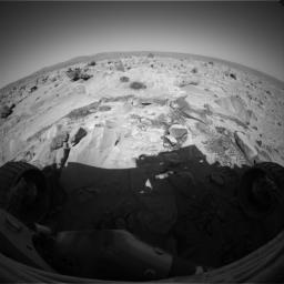
The Mars Exploration Rover Spirit took this image with its hazard-avoidance camera on sol 86 (March 31, 2004), after the rover's rock abrasion tool had brushed for three minutes on each of six locations on the rock named "Mazatzal" to create a flower-shaped mosaic.
The goal for this operation was to create a brushed area big enough for the miniature thermal emission spectrometer to capture within one of its pixels, which are 11 centimeters (4.3 inches) in diameter at the distance between the rock and the instrument. Because the rock abrasion tool creates individual brushed areas only about 5 centimeters (2 inches) in diameter, the team designed this six-location series of tool placements in order to brush 92 percent to 95 percent of the spectrometer's pixel size.

This operation was only the second time the rock abrasion tool has created a brushing mosaic. The first time was a three-spot brushing on the rock called "Humphrey." The brush was originally designed to be used as an aide during full grinding operations, however it has been very effective in brushing the top layer off of dusty martian rocks to allow scientists a multi-depth look into the rocks on Mars.


Signaler ce message à un modérateur | IP: Logguée
Temps en ligne : 8 Jours, 15 Heures, 44 Minutes, 21 Secondes en ligne

Old Post 03-04-2004 02:12
Cliquez ici pour voir le profil de Seth Cliquez ici pour lui envoyer un message privé  Trouver plus de messages de Seth Ajouter Seth à votre liste d'amis Editer/Effacer le Message Citer le message dans la réponse
 Seth  Rechercher tous les messages de ce membre Cliquez ici pour envoyer un message privé à cet utilisateur
Confirmé

Déconnecté

Niveau : 3
N° de Membre : 1512

Ancienneté : 100%
Participation : 2%
Inscription: 07 May 2002
Localisation:
Messages: 1390
Sujets Lancés : 70


http://photojournal.jpl.nasa.gov/jp...5687_modest.jpg
You will need 3D glasses
Full-Res TIFF: PIA05687.tif (2.588 MB)
http://photojournal.jpl.nasa.gov/tiff/PIA05687.tif

Citation:
This 3-D image taken by the microscopic imager on the Mars Exploration Rover Opportunity shows a close-up of the center of the rock abrasion tool hole, ground into "Bounce" on the rover's 66th sol on Mars. Features smaller than one-tenth of a millimeter (.004 inches) are visible. The observed area is a little over 3 centimeters (1.2 inches). The canyon-like crack that runs across the bottom half of the image is really only about 2 millimeters (about 0.08 inches) deep. Scientists are currently using a variety of instruments to study the chemical content of the rock.


Signaler ce message à un modérateur | IP: Logguée
Temps en ligne : 8 Jours, 15 Heures, 44 Minutes, 21 Secondes en ligne

Old Post 03-04-2004 02:14
Cliquez ici pour voir le profil de Seth Cliquez ici pour lui envoyer un message privé  Trouver plus de messages de Seth Ajouter Seth à votre liste d'amis Editer/Effacer le Message Citer le message dans la réponse
 Seth  Rechercher tous les messages de ce membre Cliquez ici pour envoyer un message privé à cet utilisateur
Confirmé

Déconnecté

Niveau : 3
N° de Membre : 1512

Ancienneté : 100%
Participation : 2%
Inscription: 07 May 2002
Localisation:
Messages: 1390
Sujets Lancés : 70


http://photojournal.jpl.nasa.gov/jp...5688_modest.jpg
PIA05688.tif (2.274 MB) http://photojournal.jpl.nasa.gov/tiff/PIA05688.tif


Citation:

http://photojournal.jpl.nasa.gov/fi...A05688_fig1.jpg
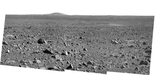
NASA's Mars Exploration Rover Spirit took this panoramic camera image on sol 86 (March 31, 2004) before driving 36 meters (118 feet) on sol 87 toward its future destination, the Columbia Hills. This is probably the last panoramic camera image that Spirit will take from the high rim of "Bonneville" crater, and provides an excellent view of the ejecta-covered path the rover has journeyed thus far. The lander can be seen toward the upper right of the frame and is approximately 321 meters (1060 feet) away from Spirit's current location. The large hill on the horizon is Grissom Hill. The Colombia Hills, located to the left, are not visible in this image.


Signaler ce message à un modérateur | IP: Logguée
Temps en ligne : 8 Jours, 15 Heures, 44 Minutes, 21 Secondes en ligne

Old Post 03-04-2004 02:16
Cliquez ici pour voir le profil de Seth Cliquez ici pour lui envoyer un message privé  Trouver plus de messages de Seth Ajouter Seth à votre liste d'amis Editer/Effacer le Message Citer le message dans la réponse
 Seth  Rechercher tous les messages de ce membre Cliquez ici pour envoyer un message privé à cet utilisateur
Confirmé

Déconnecté

Niveau : 3
N° de Membre : 1512

Ancienneté : 100%
Participation : 2%
Inscription: 07 May 2002
Localisation:
Messages: 1390
Sujets Lancés : 70


http://photojournal.jpl.nasa.gov/jp...5708_modest.jpg
PIA05708.tif (6.298 MB) http://photojournal.jpl.nasa.gov/tiff/PIA05708.tif

Citation:
3 April 2004
This Mars Global Surveyor (MGS) Mars Orbiter Camera (MOC) image shows dust-mantled layer exposures (left) in east Candor Chasma, one of the troughs of the Valles Marineris system. Erosion of the steeper slope (right) has disrupted the expression of layered material, indicating that some layered materials on Mars may not be recognized as such, depending upon how the materials have been degraded. This image is located near 7.8°S, 65.6°W. The image covers an area about 3 km (1.9 mi) across. Sunlight illuminates the scene from the left.


Signaler ce message à un modérateur | IP: Logguée
Temps en ligne : 8 Jours, 15 Heures, 44 Minutes, 21 Secondes en ligne

Old Post 07-04-2004 01:24
Cliquez ici pour voir le profil de Seth Cliquez ici pour lui envoyer un message privé  Trouver plus de messages de Seth Ajouter Seth à votre liste d'amis Editer/Effacer le Message Citer le message dans la réponse
 Seth  Rechercher tous les messages de ce membre Cliquez ici pour envoyer un message privé à cet utilisateur
Confirmé

Déconnecté

Niveau : 3
N° de Membre : 1512

Ancienneté : 100%
Participation : 2%
Inscription: 07 May 2002
Localisation:
Messages: 1390
Sujets Lancés : 70


http://photojournal.jpl.nasa.gov/jp...5709_modest.jpg
PIA05709.tif (678.3 kB) http://photojournal.jpl.nasa.gov/tiff/PIA05709.tif

Citation:
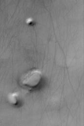
4 April 2004
This Mars Global Surveyor (MGS) Mars Orbiter Camera (MOC) image shows a mesa and two hills-each of them a remnant of formerly more extensive layered material--in the south polar region of Mars. The dark streaks were formed by passing dust devils. This picture is located near 64.6°S, 340.5°W. The image covers an area about 3 km (1.9 mi) across. Sunlight illuminates the scene from the upper left.


Signaler ce message à un modérateur | IP: Logguée
Temps en ligne : 8 Jours, 15 Heures, 44 Minutes, 21 Secondes en ligne

Old Post 07-04-2004 01:25
Cliquez ici pour voir le profil de Seth Cliquez ici pour lui envoyer un message privé  Trouver plus de messages de Seth Ajouter Seth à votre liste d'amis Editer/Effacer le Message Citer le message dans la réponse
 Seth  Rechercher tous les messages de ce membre Cliquez ici pour envoyer un message privé à cet utilisateur
Confirmé

Déconnecté

Niveau : 3
N° de Membre : 1512

Ancienneté : 100%
Participation : 2%
Inscription: 07 May 2002
Localisation:
Messages: 1390
Sujets Lancés : 70


http://photojournal.jpl.nasa.gov/jp...5710_modest.jpg
PIA05710.tif (393.8 kB) http://photojournal.jpl.nasa.gov/tiff/PIA05710.tif

Citation:
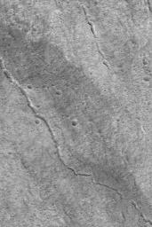
5 April 2004
This Mars Global Surveyor (MGS) Mars Orbiter Camera (MOC) image shows evidence of two collapsed lava tubes on the southeast flank of the giant martian volcano, Olympus Mons. One runs diagonally across the entire image, the other is shorter and does not extend across the whole image. The shorter one is a series of pits and troughs, rather than a continuous channel. Lava flowed in tubes under the surface; later, the roof of each tube collapsed to form a series of pits and troughs which, in the larger example, eventually coalesced to its present, channel-like form. The image is located near 16.8°N, 132.2°W, and covers an area about 3 km (1.9 mi) across. Sunlight illuminates the scene from the lower left.


Signaler ce message à un modérateur | IP: Logguée
Temps en ligne : 8 Jours, 15 Heures, 44 Minutes, 21 Secondes en ligne

Old Post 07-04-2004 01:26
Cliquez ici pour voir le profil de Seth Cliquez ici pour lui envoyer un message privé  Trouver plus de messages de Seth Ajouter Seth à votre liste d'amis Editer/Effacer le Message Citer le message dans la réponse
 Seth  Rechercher tous les messages de ce membre Cliquez ici pour envoyer un message privé à cet utilisateur
Confirmé

Déconnecté

Niveau : 3
N° de Membre : 1512

Ancienneté : 100%
Participation : 2%
Inscription: 07 May 2002
Localisation:
Messages: 1390
Sujets Lancés : 70


http://photojournal.jpl.nasa.gov/jp...5689_modest.jpg
PIA05689.tif (3.535 MB) http://photojournal.jpl.nasa.gov/tiff/PIA05689.tif


Citation:
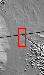
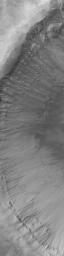
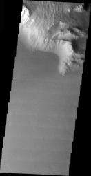
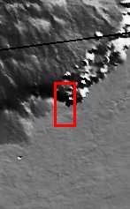
Released 5 April 2004

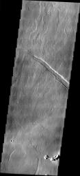
The Odyssey spacecraft has completed a full Mars year of observations of the red planet. For the next several weeks the Image of the Day will look back over this first mars year. It will focus on four themes: 1) the poles - with the seasonal changes seen in the retreat and expansion of the caps; 2) craters - with a variety of morphologies relating to impact materials and later alteration, both infilling and exhumation; 3) channels - the clues to liquid surface flow; and 4) volcanic flow features. While some images have helped answer questions about the history of Mars, many have raised new questions that are still being investigated as Odyssey continues collecting data as it orbits Mars.

This image was collected June 2, 2002 during early northern spring. The relative timing of volcanic flows from Olympus Mons and the formation of the structural feature can be deduced by which flows are cut by the fracture and which flows fill and cross the fracture.

Image information: VIS instrument. Latitude 19.8, Longitude 233 East (127 West). 19 meter/pixel resolution.

Note: this THEMIS visual image has not been radiometrically nor geometrically calibrated for this preliminary release. An empirical correction has been performed to remove instrumental effects. A linear shift has been applied in the cross-track and down-track direction to approximate spacecraft and planetary motion. Fully calibrated and geometrically projected images will be released through the Planetary Data System in accordance with Project policies at a later time.

NASA's Jet Propulsion Laboratory manages the 2001 Mars Odyssey mission for NASA's Office of Space Science, Washington, D.C. The Thermal Emission Imaging System (THEMIS) was developed by Arizona State University, Tempe, in collaboration with Raytheon Santa Barbara Remote Sensing. The THEMIS investigation is led by Dr. Philip Christensen at Arizona State University. Lockheed Martin Astronautics, Denver, is the prime contractor for the Odyssey project, and developed and built the orbiter. Mission operations are conducted jointly from Lockheed Martin and from JPL, a division of the California Institute of Technology in Pasadena.


Signaler ce message à un modérateur | IP: Logguée
Temps en ligne : 8 Jours, 15 Heures, 44 Minutes, 21 Secondes en ligne

Old Post 07-04-2004 01:27
Cliquez ici pour voir le profil de Seth Cliquez ici pour lui envoyer un message privé  Trouver plus de messages de Seth Ajouter Seth à votre liste d'amis Editer/Effacer le Message Citer le message dans la réponse
 Seth  Rechercher tous les messages de ce membre Cliquez ici pour envoyer un message privé à cet utilisateur
Confirmé

Déconnecté

Niveau : 3
N° de Membre : 1512

Ancienneté : 100%
Participation : 2%
Inscription: 07 May 2002
Localisation:
Messages: 1390
Sujets Lancés : 70


http://photojournal.jpl.nasa.gov/jp...5711_modest.jpg
PIA05711.tif (2.82 MB) http://photojournal.jpl.nasa.gov/tiff/PIA05711.tif

Citation:
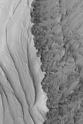
6 April 2004
This Mars Global Surveyor (MGS) Mars Orbiter Camera (MOC) image shows gullies in the wall of a large impact crater in Newton Basin near 41.9°S, 158.1°W. Such gullies may have formed by downslope movement of wet debris--i.e., water. Unfortunately, because the responsible fluid (if there was one) is no longer present today, only the geomorphology of the channels and debris aprons can be used to deduce that water might have been involved. The image covers an area about 3 km (1.9 mi) across. Sunlight illuminates the scene from the upper left.


Signaler ce message à un modérateur | IP: Logguée
Temps en ligne : 8 Jours, 15 Heures, 44 Minutes, 21 Secondes en ligne

Old Post 07-04-2004 01:29
Cliquez ici pour voir le profil de Seth Cliquez ici pour lui envoyer un message privé  Trouver plus de messages de Seth Ajouter Seth à votre liste d'amis Editer/Effacer le Message Citer le message dans la réponse
 Seth  Rechercher tous les messages de ce membre Cliquez ici pour envoyer un message privé à cet utilisateur
Confirmé

Déconnecté

Niveau : 3
N° de Membre : 1512

Ancienneté : 100%
Participation : 2%
Inscription: 07 May 2002
Localisation:
Messages: 1390
Sujets Lancés : 70


http://photojournal.jpl.nasa.gov/jp...5712_modest.jpg
PIA05712.tif (654.1 kB) http://photojournal.jpl.nasa.gov/tiff/PIA05712.tif


Citation:

Released 6 April 2004

The Odyssey spacecraft has completed a full Mars year of observations of the red planet. For the next several weeks the Image of the Day will look back over this first mars year. It will focus on four themes: 1) the poles - with the seasonal changes seen in the retreat and expansion of the caps; 2) craters - with a variety of morphologies relating to impact materials and later alteration, both infilling and exhumation; 3) channels - the clues to liquid surface flow; and 4) volcanic flow features. While some images have helped answer questions about the history of Mars, many have raised new questions that are still being investigated as Odyssey continues collecting data as it orbits Mars.

This images was collected Aug. 14, 2003 during northern fall. The top of this image shows late stage volcanic flows coming down the side of Olympus Mons and flowing over the cliff-like margin of the volcano.

Image information: VIS instrument. Latitude 13.9, Longitude 228.5 East (131.5 West). 19 meter/pixel resolution.

Note: this THEMIS visual image has not been radiometrically nor geometrically calibrated for this preliminary release. An empirical correction has been performed to remove instrumental effects. A linear shift has been applied in the cross-track and down-track direction to approximate spacecraft and planetary motion. Fully calibrated and geometrically projected images will be released through the Planetary Data System in accordance with Project policies at a later time.

NASA's Jet Propulsion Laboratory manages the 2001 Mars Odyssey mission for NASA's Office of Space Science, Washington, D.C. The Thermal Emission Imaging System (THEMIS) was developed by Arizona State University, Tempe, in collaboration with Raytheon Santa Barbara Remote Sensing. The THEMIS investigation is led by Dr. Philip Christensen at Arizona State University. Lockheed Martin Astronautics, Denver, is the prime contractor for the Odyssey project, and developed and built the orbiter. Mission operations are conducted jointly from Lockheed Martin and from JPL, a division of the California Institute of Technology in Pasadena.


Signaler ce message à un modérateur | IP: Logguée
Temps en ligne : 8 Jours, 15 Heures, 44 Minutes, 21 Secondes en ligne

Old Post 07-04-2004 01:30
Cliquez ici pour voir le profil de Seth Cliquez ici pour lui envoyer un message privé  Trouver plus de messages de Seth Ajouter Seth à votre liste d'amis Editer/Effacer le Message Citer le message dans la réponse
Il est actuellement 13:46 (GMT) Poster un nouveau sujet    Poster une réponse   
Page(s) (49): [ <<   <   27   28   29   30   31   32   33   34   35   36   37   38   39   40   41   42   43   44   45   >   >> ]  Sujet précédent   Sujet suivant
Forum OXMO > Section Généraliste > Discussion Libre > Je vous parle en direct de Mars (Opportunity a atterri !)

Aller au Forum:
Notez ce sujet :


 Réponse Rapide
Titre: (Optionnel)
Message:

Convertir automatiquement les URLs Montrer la Signature
Afficher une version imprimable | Envoyer cette page par email | S'inscrire à ce sujet | Télécharger ce sujet
Règles du forum :
Créer de nouveaux sujets
Répondre aux messages
Attacher des fichiers
Editer vos messages
: not autorisé
: not autorisé
: not autorisé
: not autorisé
Le Code HTML est OFF
Le Code vB est ON
Les Smileys sont ONs
Le code [IMG] est ON
 
< Contactez-nous - Forum OXMO>

Uptime du serveur SQL : 2 jour(s) 13 heure(s) et 23 minute(s)
Page générée en 0.023470 secondes en exécutant 42 requêtes SQL.
Apache - Compression GZIP : Activée.