Accueil Foire Aux Questions Trouver d'autres membres Rechercher Utilisez le vBpad pour stocker des notes personnelles Ici, vous pouvez voir les sujets auxquels vous avez souscris, vos messages privés; et modifier vos informations personnelles et préférences. Statistiques du forum Enregistrez vous gratuitement ! Se déconnecter  
Forum OXMO Forum OXMO > Section Généraliste > Discussion Libre > Je vous parle en direct de Mars (Opportunity a atterri !)


Aller au Forum:
Notez ce sujet :

Page(s) (49): [ <<   <   30   31   32   33   34   35   36   37   38   39   40   41   42   43   44   45   46   47   48   >   >> ]   Sujet précédent   Sujet suivant
Auteur
Sujet Poster un nouveau sujet    Poster une réponse
 Seth  Rechercher tous les messages de ce membre Cliquez ici pour envoyer un message privé à cet utilisateur
Confirmé

Déconnecté

Niveau : 3
N° de Membre : 1512

Ancienneté : 100%
Participation : 2%
Inscription: 07 May 2002
Localisation:
Messages: 1390
Sujets Lancés : 70


http://photojournal.jpl.nasa.gov/jp...5753_modest.jpg
PIA05753.tif (901.9 kB) http://photojournal.jpl.nasa.gov/tiff/PIA05753.tif

Citation:
This image taken by the hazard-avoidance camera on the Mars Exploration Rover Spirit on sol 99 shows the rock dubbed "Route 66" and a flower-shaped brush mark made by the rover's rock abrasion tool. The image was taken after a four-day break for flight software updates and confirms that these updates were successful.


Signaler ce message à un modérateur | IP: Logguée
Temps en ligne : 8 Jours, 15 Heures, 44 Minutes, 21 Secondes en ligne

Old Post 15-04-2004 02:34
Cliquez ici pour voir le profil de Seth Cliquez ici pour lui envoyer un message privé  Trouver plus de messages de Seth Ajouter Seth à votre liste d'amis Editer/Effacer le Message Citer le message dans la réponse
 Seth  Rechercher tous les messages de ce membre Cliquez ici pour envoyer un message privé à cet utilisateur
Confirmé

Déconnecté

Niveau : 3
N° de Membre : 1512

Ancienneté : 100%
Participation : 2%
Inscription: 07 May 2002
Localisation:
Messages: 1390
Sujets Lancés : 70


Animated GIF (5.433 megabytes) http://photojournal.jpl.nasa.gov/archive/PIA05754.gif

Citation:
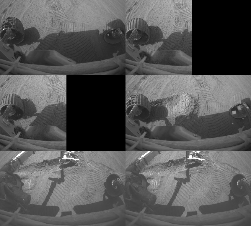
This animation shows the Mars Exploration Rover Opportunity digging a trench near the trough dubbed "Anatolia" with its left front wheel on sol 73. It was taken by the rover's hazard-avoidance camera.

The trench was dug so that Opportunity would be able to place its Moessbauer spectrometer on a soil target (the pile of material on the right side of the trench) during a four-day flight software update. The rover's alpha particle X-ray spectrometer was pointed at the sky at this time taking calibration measurements.

Spirit performed a similar operation during its flight software update, but its Moessbauer was placed on a rock dubbed "Route 66." Since there are no rocks at Opportunity's current location, rover team members chose a patch of soil.

The trench itself is 95 centimeters (38 inches) long by 16 centimeters (6 inches) wide by 11 centimeters (4 inches) deep. It is the deepest hole dug by either Spirit or Opportunity to date.


Signaler ce message à un modérateur | IP: Logguée
Temps en ligne : 8 Jours, 15 Heures, 44 Minutes, 21 Secondes en ligne

Old Post 15-04-2004 02:35
Cliquez ici pour voir le profil de Seth Cliquez ici pour lui envoyer un message privé  Trouver plus de messages de Seth Ajouter Seth à votre liste d'amis Editer/Effacer le Message Citer le message dans la réponse
 Seth  Rechercher tous les messages de ce membre Cliquez ici pour envoyer un message privé à cet utilisateur
Confirmé

Déconnecté

Niveau : 3
N° de Membre : 1512

Ancienneté : 100%
Participation : 2%
Inscription: 07 May 2002
Localisation:
Messages: 1390
Sujets Lancés : 70


http://photojournal.jpl.nasa.gov/jp...5755_modest.jpg
PIA05755.tif (38.52 MB) http://photojournal.jpl.nasa.gov/tiff/PIA05755.tif

Citation:
This approximate true-color panorama, dubbed "Lion King," shows "Eagle Crater" and the surrounding plains of Meridiani Planum. It was obtained by the Mars Exploration Rover Opportunity's panoramic camera on sols 58 and 60 using infrared (750-nanometer), green (530-nanometer) and blue (430-nanometer) filters.

This is the largest panorama obtained yet by either rover. It was taken in eight segments using six filters per segment, for a total of 558 images and more than 75 megabytes of data. Additional lower elevation tiers were added to ensure that the entire crater was covered in the mosaic.

This panorama depicts a story of exploration including the rover's lander, a thorough examination of the outcrop, a study of the soils at the near-side of the lander, a successful exit from Eagle Crater and finally the rover's next desination, the large crater dubbed "Endurance".


Signaler ce message à un modérateur | IP: Logguée
Temps en ligne : 8 Jours, 15 Heures, 44 Minutes, 21 Secondes en ligne

Old Post 15-04-2004 02:36
Cliquez ici pour voir le profil de Seth Cliquez ici pour lui envoyer un message privé  Trouver plus de messages de Seth Ajouter Seth à votre liste d'amis Editer/Effacer le Message Citer le message dans la réponse
 Solacin  Rechercher tous les messages de ce membre Cliquez ici pour envoyer un message privé à cet utilisateur
Guru

Déconnecté

Niveau : 5
N° de Membre : 11117

Ancienneté : 96%
Participation : 10%
Inscription: 23 Mar 2003
Localisation: 974
Age: 52
Messages: 8253
Sujets Lancés : 28

Chouette chouette !!! de la couleur encore
Et bientôt un nouveau logiciel pour nos p'tits robots pour qu'ils puissent continuer leurs explorations


__________________


Signaler ce message à un modérateur | IP: Logguée
Temps en ligne : 25 Jours, 5 Heures, 18 Minutes, 53 Secondes en ligne

Old Post 15-04-2004 06:00
Cliquez ici pour voir le profil de Solacin Cliquez ici pour lui envoyer un message privé  Trouver plus de messages de Solacin Ajouter Solacin à votre liste d'amis       Editer/Effacer le Message Citer le message dans la réponse
 Seth  Rechercher tous les messages de ce membre Cliquez ici pour envoyer un message privé à cet utilisateur
Confirmé

Déconnecté

Niveau : 3
N° de Membre : 1512

Ancienneté : 100%
Participation : 2%
Inscription: 07 May 2002
Localisation:
Messages: 1390
Sujets Lancés : 70

.
http://photojournal.jpl.nasa.gov/jp...5756_modest.jpg

Citation:
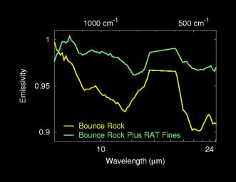
This graph shows the light signatures, or spectra, of two sides of the rock dubbed "Bounce," located at Meridiani Planum, Mars. The spectra were taken by the miniature thermal emission spectrometer on the Mars Exploration Rover Opportunity. The left side of this rock is covered by fine dust created when the rover drilled into the rock with its rock abrasion tool. These "fines" produce a layer of pyroxene dust that can be detected here in the top spectrum. The right side of the rock has fewer fines and was used to investigate the composition of this basaltic rock.


Signaler ce message à un modérateur | IP: Logguée
Temps en ligne : 8 Jours, 15 Heures, 44 Minutes, 21 Secondes en ligne

Old Post 16-04-2004 01:21
Cliquez ici pour voir le profil de Seth Cliquez ici pour lui envoyer un message privé  Trouver plus de messages de Seth Ajouter Seth à votre liste d'amis Editer/Effacer le Message Citer le message dans la réponse
 Seth  Rechercher tous les messages de ce membre Cliquez ici pour envoyer un message privé à cet utilisateur
Confirmé

Déconnecté

Niveau : 3
N° de Membre : 1512

Ancienneté : 100%
Participation : 2%
Inscription: 07 May 2002
Localisation:
Messages: 1390
Sujets Lancés : 70


http://photojournal.jpl.nasa.gov/jp...5757_modest.jpg

Citation:
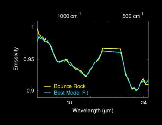
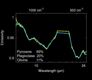
The mineralogy of "Bounce" rock was determined by fitting spectra from a library of laboratory minerals to the spectrum of Bounce taken by the Mars Exploration Rover Opportunity's miniature thermal emission spectrometer. The minerals that give the best fit include pyroxene, plagioclase and olivine -- minerals commonly found in basaltic volcanic rocks -- and typical martian dust produced by the rover's rock abrasion tool.


Signaler ce message à un modérateur | IP: Logguée
Temps en ligne : 8 Jours, 15 Heures, 44 Minutes, 21 Secondes en ligne

Old Post 16-04-2004 01:22
Cliquez ici pour voir le profil de Seth Cliquez ici pour lui envoyer un message privé  Trouver plus de messages de Seth Ajouter Seth à votre liste d'amis Editer/Effacer le Message Citer le message dans la réponse
 Seth  Rechercher tous les messages de ce membre Cliquez ici pour envoyer un message privé à cet utilisateur
Confirmé

Déconnecté

Niveau : 3
N° de Membre : 1512

Ancienneté : 100%
Participation : 2%
Inscription: 07 May 2002
Localisation:
Messages: 1390
Sujets Lancés : 70


http://photojournal.jpl.nasa.gov/jp...5758_modest.jpg

Citation:
The mineralogy of "Bounce" rock was determined by fitting spectra from a library of laboratory minerals to spectra of Bounce taken by the Mars Exploration Rover Opportunity's miniature thermal emission spectrometer. Bounce is made-up of 69 percent pyroxene, 20 percent plagioclase, and 11 percent olivine. The pyroxene minerals are primarily calcium-rich varieties, with smaller amounts of a class of minerals called orthopyroxenes. The composition of Bounce is significantly different from that of typical martian basalts seen over much of the surface from orbit by the Mars Global Surveyor thermal emission spectrometer. The rock's composition is, however, similar to that of meteorites thought to have come from Mars. No detectable hematite was found in Bounce.


Signaler ce message à un modérateur | IP: Logguée
Temps en ligne : 8 Jours, 15 Heures, 44 Minutes, 21 Secondes en ligne

Old Post 16-04-2004 01:22
Cliquez ici pour voir le profil de Seth Cliquez ici pour lui envoyer un message privé  Trouver plus de messages de Seth Ajouter Seth à votre liste d'amis Editer/Effacer le Message Citer le message dans la réponse
 Seth  Rechercher tous les messages de ce membre Cliquez ici pour envoyer un message privé à cet utilisateur
Confirmé

Déconnecté

Niveau : 3
N° de Membre : 1512

Ancienneté : 100%
Participation : 2%
Inscription: 07 May 2002
Localisation:
Messages: 1390
Sujets Lancés : 70


http://photojournal.jpl.nasa.gov/jp...5759_modest.jpg
PIA05759.tif (7.428 MB) http://photojournal.jpl.nasa.gov/tiff/PIA05759.tif

Citation:
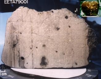
This meteorite, a basalt lava rock nearly indistinguishable from many Earth rocks, provided the first strong proof that meteorites could come from Mars. Originally weighing nearly 8 kilograms (17.6 pounds), it was collected in 1979 in the Elephant Moraine area of Antarctica. The side of the cube at the lower left in this image measures 1 centimeter (0.4 inches).

This picture shows a sawn face of this fine-grained gray rock. (The vertical stripes are saw marks.) The black patches in the rock are melted rock, or glass, formed when a large meteorite hit Mars near the rock. The meteorite impact probably threw this rock, dubbed "EETA79001," off Mars and toward Antarctica on Earth. The black glass contains traces of martian atmosphere gases.

The Mars Exploration Rover Opportunity has discovered that a rock dubbed "Bounce" at Meridiani Planum has a very similar mineral composition to this meteorite and likely shares common origins. Bounce itself is thought to have originated outside the area surrounding Opportunity's landing site; an impact or collision likely threw the rock away from its primary home.


Signaler ce message à un modérateur | IP: Logguée
Temps en ligne : 8 Jours, 15 Heures, 44 Minutes, 21 Secondes en ligne

Old Post 16-04-2004 01:23
Cliquez ici pour voir le profil de Seth Cliquez ici pour lui envoyer un message privé  Trouver plus de messages de Seth Ajouter Seth à votre liste d'amis Editer/Effacer le Message Citer le message dans la réponse
 Seth  Rechercher tous les messages de ce membre Cliquez ici pour envoyer un message privé à cet utilisateur
Confirmé

Déconnecté

Niveau : 3
N° de Membre : 1512

Ancienneté : 100%
Participation : 2%
Inscription: 07 May 2002
Localisation:
Messages: 1390
Sujets Lancés : 70


http://photojournal.jpl.nasa.gov/jp...5760_modest.jpg
PIA05760.tif (15.13 MB) http://photojournal.jpl.nasa.gov/tiff/PIA05760.tif


Citation:

http://photojournal.jpl.nasa.gov/fi...A05760_fig1.jpg
Figure 1


http://photojournal.jpl.nasa.gov/fi...A05760_fig2.jpg
Figure 2


http://photojournal.jpl.nasa.gov/fi...A05760_fig3.jpg
Figure 3

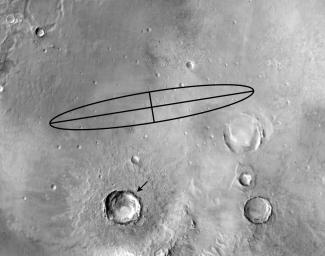
The rock dubbed "Bounce" at Meridiani Planum, Mars, may have been thrown onto the plains during an impact that formed a 25-kilometer-diameter (15.5-mile) crater (arrow) located 50 kilometers (31 miles) southeast of the Mars Exploration Rover Opportunity's landing site (to the right of ellipse center). This infrared Mars Odyssey image taken by the thermal emission imaging system shows the pattern of ejecta, or material, thrown from the large crater. Rays of this rocky material can be seen radiating outward from the crater. The Opportunity landing site is close to one of these rays, as well as other rays of small impact craters seen in high-resolution Mars Odyssey camera images within 5 kilometers (3.1 miles) of the landing site. Bounce rock may be a smaller piece of material ejected onto the plains by this impact event.


Figures 1, 2, and 3 above, infrared images increasing in zoom, taken by the thermal emission imaging system on the Mars Odyssey orbiter at night, show the pattern of ejecta, or material, thrown from the large crater. Large rocks on the surface stay warm at night and produce a bright signature. Rays of this rocky material can be seen radiating outward from the crater.


Signaler ce message à un modérateur | IP: Logguée
Temps en ligne : 8 Jours, 15 Heures, 44 Minutes, 21 Secondes en ligne

Old Post 16-04-2004 01:25
Cliquez ici pour voir le profil de Seth Cliquez ici pour lui envoyer un message privé  Trouver plus de messages de Seth Ajouter Seth à votre liste d'amis Editer/Effacer le Message Citer le message dans la réponse
 Seth  Rechercher tous les messages de ce membre Cliquez ici pour envoyer un message privé à cet utilisateur
Confirmé

Déconnecté

Niveau : 3
N° de Membre : 1512

Ancienneté : 100%
Participation : 2%
Inscription: 07 May 2002
Localisation:
Messages: 1390
Sujets Lancés : 70


http://photojournal.jpl.nasa.gov/jp...5761_modest.jpg
PIA05761.tif (1.05 MB) http://photojournal.jpl.nasa.gov/tiff/PIA05761.tif

Citation:
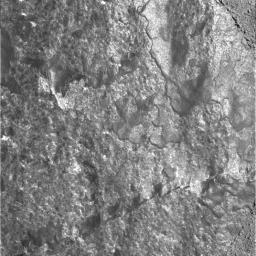
This image was taken by the microscopic imager onboard NASA's Mars Exploration Rover Spirit on sol 99 (April 13, 2004). It is a close-up look at a portion of the rock called "Route 66," which was brushed by the rover's rock abrasion tool.

This image intrigues scientists because it looks very different from the microscopic images taken of other brushed rocks at the Gusev Crater location. The surface of Route 66 is very shiny and specularly reflective, which may indicate a glassy surface, or perhaps a very smooth, discontinuous coating. The unique coating appears mottled and may be multi-layered.

Other interesting features in this brushed area of Route 66 are the very thin, arc-shaped lines that are visible in the upper left quadrant of the image. An initial hypothesis suggests that these arcs may have been caused by the rock abrasion tool when the instrument made its initial contact with the surface.

Scientists will use the combined data from the rover's Moessbauer spectrometer and alpha particle X-ray spectrometer along with color versions of this image to try to reach stronger conclusions about what they are seeing and what processes caused the features.


Signaler ce message à un modérateur | IP: Logguée
Temps en ligne : 8 Jours, 15 Heures, 44 Minutes, 21 Secondes en ligne

Old Post 16-04-2004 01:27
Cliquez ici pour voir le profil de Seth Cliquez ici pour lui envoyer un message privé  Trouver plus de messages de Seth Ajouter Seth à votre liste d'amis Editer/Effacer le Message Citer le message dans la réponse
 Seth  Rechercher tous les messages de ce membre Cliquez ici pour envoyer un message privé à cet utilisateur
Confirmé

Déconnecté

Niveau : 3
N° de Membre : 1512

Ancienneté : 100%
Participation : 2%
Inscription: 07 May 2002
Localisation:
Messages: 1390
Sujets Lancés : 70


http://photojournal.jpl.nasa.gov/jp...5762_modest.jpg
PIA05762.tif (2.831 MB) http://photojournal.jpl.nasa.gov/tiff/PIA05762.tif


Citation:
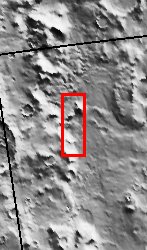
Released 15 April 2004

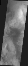
The Odyssey spacecraft has completed a full Mars year of observations of the red planet. For the next several weeks the Image of the Day will look back over this first mars year. It will focus on four themes: 1) the poles - with the seasonal changes seen in the retreat and expansion of the caps; 2) craters - with a variety of morphologies relating to impact materials and later alteration, both infilling and exhumation; 3) channels - the clues to liquid surface flow; and 4) volcanic flow features. While some images have helped answer questions about the history of Mars, many have raised new questions that are still being investigated as Odyssey continues collecting data as it orbits Mars.

This daytime VIS image was collected on December 14, 2003 during the southern summer season on the Hellas Basin Rim.

Image information: VIS instrument. Latitude -41.3, Longitude 46.4 East (313.6 West). 19 meter/pixel resolution.

Note: this THEMIS visual image has not been radiometrically nor geometrically calibrated for this preliminary release. An empirical correction has been performed to remove instrumental effects. A linear shift has been applied in the cross-track and down-track direction to approximate spacecraft and planetary motion. Fully calibrated and geometrically projected images will be released through the Planetary Data System in accordance with Project policies at a later time.

NASA's Jet Propulsion Laboratory manages the 2001 Mars Odyssey mission for NASA's Office of Space Science, Washington, D.C. The Thermal Emission Imaging System (THEMIS) was developed by Arizona State University, Tempe, in collaboration with Raytheon Santa Barbara Remote Sensing. The THEMIS investigation is led by Dr. Philip Christensen at Arizona State University. Lockheed Martin Astronautics, Denver, is the prime contractor for the Odyssey project, and developed and built the orbiter. Mission operations are conducted jointly from Lockheed Martin and from JPL, a division of the California Institute of Technology in Pasadena.


Signaler ce message à un modérateur | IP: Logguée
Temps en ligne : 8 Jours, 15 Heures, 44 Minutes, 21 Secondes en ligne

Old Post 16-04-2004 01:28
Cliquez ici pour voir le profil de Seth Cliquez ici pour lui envoyer un message privé  Trouver plus de messages de Seth Ajouter Seth à votre liste d'amis Editer/Effacer le Message Citer le message dans la réponse
 Seth  Rechercher tous les messages de ce membre Cliquez ici pour envoyer un message privé à cet utilisateur
Confirmé

Déconnecté

Niveau : 3
N° de Membre : 1512

Ancienneté : 100%
Participation : 2%
Inscription: 07 May 2002
Localisation:
Messages: 1390
Sujets Lancés : 70


http://photojournal.jpl.nasa.gov/jp...5763_modest.jpg
PIA05763.tif (1.05 MB) http://photojournal.jpl.nasa.gov/tiff/PIA05763.tif

Citation:
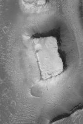
This Mars Global Surveyor (MGS) Mars Orbiter Camera (MOC) image shows a mesa left standing when erosion created the Granicus Valles system, located west of the Elysium volcanoes near 27.8°N, 224.3°W. Dark dots at the base of the mesa's slopes and on the valley floor are large boulders. The image covers an area about 3 km (1.9 mi) across. Sunlight illuminates the scene from the lower left.


Signaler ce message à un modérateur | IP: Logguée
Temps en ligne : 8 Jours, 15 Heures, 44 Minutes, 21 Secondes en ligne

Old Post 16-04-2004 01:29
Cliquez ici pour voir le profil de Seth Cliquez ici pour lui envoyer un message privé  Trouver plus de messages de Seth Ajouter Seth à votre liste d'amis Editer/Effacer le Message Citer le message dans la réponse
 Solacin  Rechercher tous les messages de ce membre Cliquez ici pour envoyer un message privé à cet utilisateur
Guru

Déconnecté

Niveau : 5
N° de Membre : 11117

Ancienneté : 96%
Participation : 10%
Inscription: 23 Mar 2003
Localisation: 974
Age: 52
Messages: 8253
Sujets Lancés : 28

Whouaaaaaaaaaaaaah !! la photo de cette mesa est superbe ......... encore !!!


__________________


Signaler ce message à un modérateur | IP: Logguée
Temps en ligne : 25 Jours, 5 Heures, 18 Minutes, 53 Secondes en ligne

Old Post 16-04-2004 05:27
Cliquez ici pour voir le profil de Solacin Cliquez ici pour lui envoyer un message privé  Trouver plus de messages de Solacin Ajouter Solacin à votre liste d'amis       Editer/Effacer le Message Citer le message dans la réponse
 Seth  Rechercher tous les messages de ce membre Cliquez ici pour envoyer un message privé à cet utilisateur
Confirmé

Déconnecté

Niveau : 3
N° de Membre : 1512

Ancienneté : 100%
Participation : 2%
Inscription: 07 May 2002
Localisation:
Messages: 1390
Sujets Lancés : 70


http://photojournal.jpl.nasa.gov/jp...5072_modest.jpg
PIA05072.tif (2.239 MB) http://photojournal.jpl.nasa.gov/tiff/PIA05072.tif

Citation:
This mosaic image from the Mars Exploration Rover Opportunity's panoramic camera provides an overview of the rover's drive direction toward "Endurance Crater," which is in the upper right corner of image.

The plains appear to be uniform in character from the rovers current position all the way to Endurance Crater. Granules of various sizes blanket the plains. Spherical granules fancifully called blueberries are present some intact and some broken. Larger granules pave the surface, while smaller grains, including broken blueberries, form small dunes. Randomly distributed 1-centimeter (0.4 inch) sized pebbles (as seen just left of center in the foreground of the image) make up a third type of feature on the plains. The pebbles' composition remains to be determined. Scientists plan to examine these in the coming sols.

Examination of this part of Mars by NASA's Mars Global Surveyor orbiter revealed the presence of hematite, which led NASA to choose Meridiani Planum as Opportunity's landing site. The rover science conducted on the plains of Meridiani Planum serves to integrate what the rovers are seeing on the ground with what orbital data have shown.

Opportunity will make stop at a small crater called "Fram" (seen in the upper left, with relatively large rocks nearby) before heading to the rim of Endurance Crater.


Signaler ce message à un modérateur | IP: Logguée
Temps en ligne : 8 Jours, 15 Heures, 44 Minutes, 21 Secondes en ligne

Old Post 17-04-2004 03:12
Cliquez ici pour voir le profil de Seth Cliquez ici pour lui envoyer un message privé  Trouver plus de messages de Seth Ajouter Seth à votre liste d'amis Editer/Effacer le Message Citer le message dans la réponse
 Seth  Rechercher tous les messages de ce membre Cliquez ici pour envoyer un message privé à cet utilisateur
Confirmé

Déconnecté

Niveau : 3
N° de Membre : 1512

Ancienneté : 100%
Participation : 2%
Inscription: 07 May 2002
Localisation:
Messages: 1390
Sujets Lancés : 70


http://photojournal.jpl.nasa.gov/jp...5073_modest.jpg
PIA05073.tif (1.05 MB) http://photojournal.jpl.nasa.gov/tiff/PIA05073.tif

Citation:
NASA's Mars Exploration Rover Spirit took this grey-scale panoramic camera image on sol 100, April 14, 2004. It captures Spirit's future destination at the highlands informally named "Columbia Hills". In this image, the hills are approximately 2.4 kilometers (1.5 miles) to the southeast.

Scientists believe the hills may consist of different and potentially older rock units than the basalts that Spirit has observed so far.


Signaler ce message à un modérateur | IP: Logguée
Temps en ligne : 8 Jours, 15 Heures, 44 Minutes, 21 Secondes en ligne

Old Post 17-04-2004 03:13
Cliquez ici pour voir le profil de Seth Cliquez ici pour lui envoyer un message privé  Trouver plus de messages de Seth Ajouter Seth à votre liste d'amis Editer/Effacer le Message Citer le message dans la réponse
Il est actuellement 13:46 (GMT) Poster un nouveau sujet    Poster une réponse   
Page(s) (49): [ <<   <   30   31   32   33   34   35   36   37   38   39   40   41   42   43   44   45   46   47   48   >   >> ]  Sujet précédent   Sujet suivant
Forum OXMO > Section Généraliste > Discussion Libre > Je vous parle en direct de Mars (Opportunity a atterri !)

Aller au Forum:
Notez ce sujet :


 Réponse Rapide
Titre: (Optionnel)
Message:

Convertir automatiquement les URLs Montrer la Signature
Afficher une version imprimable | Envoyer cette page par email | S'inscrire à ce sujet | Télécharger ce sujet
Règles du forum :
Créer de nouveaux sujets
Répondre aux messages
Attacher des fichiers
Editer vos messages
: not autorisé
: not autorisé
: not autorisé
: not autorisé
Le Code HTML est OFF
Le Code vB est ON
Les Smileys sont ONs
Le code [IMG] est ON
 
< Contactez-nous - Forum OXMO>

Uptime du serveur SQL : 2 jour(s) 13 heure(s) et 22 minute(s)
Page générée en 0.024518 secondes en exécutant 42 requêtes SQL.
Apache - Compression GZIP : Activée.