Accueil Foire Aux Questions Trouver d'autres membres Rechercher Utilisez le vBpad pour stocker des notes personnelles Ici, vous pouvez voir les sujets auxquels vous avez souscris, vos messages privés; et modifier vos informations personnelles et préférences. Statistiques du forum Enregistrez vous gratuitement ! Se déconnecter  
Forum OXMO Forum OXMO > Section Généraliste > Discussion Libre > Je vous parle en direct de Mars (Opportunity a atterri !)


Aller au Forum:
Notez ce sujet :

Page(s) (49): [ <<   <   35   36   37   38   39   40   41   42   43   44   45   46   47   48   49   > ]   Sujet précédent   Sujet suivant
Auteur
Sujet Poster un nouveau sujet    Poster une réponse
 Seth  Rechercher tous les messages de ce membre Cliquez ici pour envoyer un message privé à cet utilisateur
Confirmé

Déconnecté

Niveau : 3
N° de Membre : 1512

Ancienneté : 100%
Participation : 2%
Inscription: 07 May 2002
Localisation:
Messages: 1390
Sujets Lancés : 70


http://photojournal.jpl.nasa.gov/jp...5819_modest.jpg
PIA05819.tif (12.28 MB) http://photojournal.jpl.nasa.gov/tiff/PIA05819.tif

Citation:
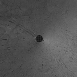
This vertical projection was assembled from images taken by the navigation camera on the Mars Exploration Rover Spirit on sol 110 (April 24, 2004) at a region dubbed "site 35." Spirit is sitting approximately 33 meters (100 feet) away from the northeast rim of "Missoula" crater.


Signaler ce message à un modérateur | IP: Logguée
Temps en ligne : 8 Jours, 15 Heures, 44 Minutes, 21 Secondes en ligne

Old Post 30-04-2004 02:53
Cliquez ici pour voir le profil de Seth Cliquez ici pour lui envoyer un message privé  Trouver plus de messages de Seth Ajouter Seth à votre liste d'amis Editer/Effacer le Message Citer le message dans la réponse
 Seth  Rechercher tous les messages de ce membre Cliquez ici pour envoyer un message privé à cet utilisateur
Confirmé

Déconnecté

Niveau : 3
N° de Membre : 1512

Ancienneté : 100%
Participation : 2%
Inscription: 07 May 2002
Localisation:
Messages: 1390
Sujets Lancés : 70


http://photojournal.jpl.nasa.gov/jp...5830_modest.jpg
PIA05830.tif (1.575 MB) http://photojournal.jpl.nasa.gov/tiff/PIA05830.tif

Citation:
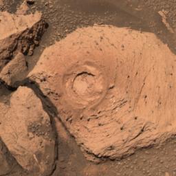
This approximate true-color image taken by the panoramic camera on the Mars Exploration Rover Opportunity show the hole drilled into the rock called "Pilbara," which is located in the small crater dubbed "Fram." Spirit drilled into this rock with its rock abrasion tool. The rock appears to be dotted with the same "blueberries," or spherules, found at "Eagle Crater." After analyzing the hole with the rover's scientific instruments, scientists concluded that Pilbara has a similar chemical make-up, and thus watery past, to rocks studied at Eagle Crater. This image was taken with the panoramic camera's 480-, 530- and 600-nanometer filters.


Signaler ce message à un modérateur | IP: Logguée
Temps en ligne : 8 Jours, 15 Heures, 44 Minutes, 21 Secondes en ligne

Old Post 30-04-2004 02:53
Cliquez ici pour voir le profil de Seth Cliquez ici pour lui envoyer un message privé  Trouver plus de messages de Seth Ajouter Seth à votre liste d'amis Editer/Effacer le Message Citer le message dans la réponse
 Seth  Rechercher tous les messages de ce membre Cliquez ici pour envoyer un message privé à cet utilisateur
Confirmé

Déconnecté

Niveau : 3
N° de Membre : 1512

Ancienneté : 100%
Participation : 2%
Inscription: 07 May 2002
Localisation:
Messages: 1390
Sujets Lancés : 70


http://photojournal.jpl.nasa.gov/jp...5820_modest.jpg
PIA05820.tif (1.297 MB) http://photojournal.jpl.nasa.gov/tiff/PIA05820.tif

Citation:
27 April 2004
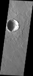
Sporadic, localized dust storms are common at high southern latitudes in early autumn. The most recent autumn for the southern hemisphere began on 5 March 2004. This late March 2004 narrow angle camera image was acquired by the Mars Global Surveyor (MGS) Mars Orbiter Camera (MOC) as it passed over a crater in southern Noachis Terra near 59.6°S, 2.7°W. The northern portion of the image is clear enough that details such as large boulders or small knobs can be seen. The rest of the image, however, shows billowy clouds of dust being raised from the surface. The picture covers an area about 3 km (1.9 mi) across. Sunlight illuminates the scene from the upper left.


Signaler ce message à un modérateur | IP: Logguée
Temps en ligne : 8 Jours, 15 Heures, 44 Minutes, 21 Secondes en ligne

Old Post 30-04-2004 02:54
Cliquez ici pour voir le profil de Seth Cliquez ici pour lui envoyer un message privé  Trouver plus de messages de Seth Ajouter Seth à votre liste d'amis Editer/Effacer le Message Citer le message dans la réponse
 Seth  Rechercher tous les messages de ce membre Cliquez ici pour envoyer un message privé à cet utilisateur
Confirmé

Déconnecté

Niveau : 3
N° de Membre : 1512

Ancienneté : 100%
Participation : 2%
Inscription: 07 May 2002
Localisation:
Messages: 1390
Sujets Lancés : 70


http://photojournal.jpl.nasa.gov/jp...5821_modest.jpg
PIA05821.tif (2.881 MB) http://photojournal.jpl.nasa.gov/tiff/PIA05821.tif


Citation:

Released 27 April 2004

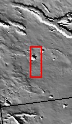
We began MSIP with 122 students divided into 24 teams. Each team created a proposal and, through the peer review process, seven proposals were selected. Two teams were formed to actually select a site. The Elysium Mons lava flow site was selected by the "Crater" group. The context image showed one large crater and what looked like many smaller craters. That would be an ideal site for the groups. The actual THEMIS image indeed contains one large crater with layered details in the walls, and many smaller craters. One team went on to attempt to find the relative age of the Elysium Mons lava flow by comparing its crater count to the crater count of a known age lava flow on our own Moon.

Image information: VIS instrument. Latitude 26.3, Longitude 141.4 East (218.6 West). 19 meter/pixel resolution.

NASA and Arizona State University™s Mars Education Program is offering students nationwide the opportunity to be involved in authentic Mars research by participating in the Mars Student Imaging Project (MSIP). Teams of students in grades 5 through college sophomore level have the opportunity to work with scientists, mission planners and educators on the THEMIS team at ASU™s Mars Space Flight Facility, to image a site on Mars using the THEMIS visible wavelength camera. For more information go to the MSIP website: http://msip.asu.edu.

Note: this THEMIS visual image has not been radiometrically nor geometrically calibrated for this preliminary release. An empirical correction has been performed to remove instrumental effects. A linear shift has been applied in the cross-track and down-track direction to approximate spacecraft and planetary motion. Fully calibrated and geometrically projected images will be released through the Planetary Data System in accordance with Project policies at a later time.

NASA's Jet Propulsion Laboratory manages the 2001 Mars Odyssey mission for NASA's Office of Space Science, Washington, D.C. The Thermal Emission Imaging System (THEMIS) was developed by Arizona State University, Tempe, in collaboration with Raytheon Santa Barbara Remote Sensing. The THEMIS investigation is led by Dr. Philip Christensen at Arizona State University. Lockheed Martin Astronautics, Denver, is the prime contractor for the Odyssey project, and developed and built the orbiter. Mission operations are conducted jointly from Lockheed Martin and from JPL, a division of the California Institute of Technology in Pasadena.


Signaler ce message à un modérateur | IP: Logguée
Temps en ligne : 8 Jours, 15 Heures, 44 Minutes, 21 Secondes en ligne

Old Post 30-04-2004 02:56
Cliquez ici pour voir le profil de Seth Cliquez ici pour lui envoyer un message privé  Trouver plus de messages de Seth Ajouter Seth à votre liste d'amis Editer/Effacer le Message Citer le message dans la réponse
 Seth  Rechercher tous les messages de ce membre Cliquez ici pour envoyer un message privé à cet utilisateur
Confirmé

Déconnecté

Niveau : 3
N° de Membre : 1512

Ancienneté : 100%
Participation : 2%
Inscription: 07 May 2002
Localisation:
Messages: 1390
Sujets Lancés : 70


http://photojournal.jpl.nasa.gov/jp...5822_modest.jpg
PIA05822.tif (4.523 MB) http://photojournal.jpl.nasa.gov/tiff/PIA05822.tif

Citation:
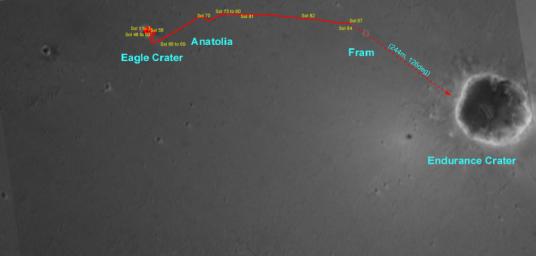
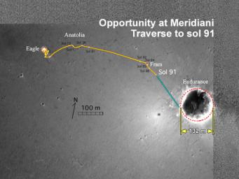
This overview map made from Mars Orbiter camera images illustrates the path that the Mars Exploration Rover Opportunity has taken from its first sol on the red planet through its 87th sol. After thoroughly examining its "Eagle Crater" landing-site, the rover moved onto the plains of Meridiani Planum, stopping to examine a curious trough and a target within it called "Anatolia." Following that, Opportunity approached and remotely studied the rocky dish called "Fram Crater." As of its 91st sol (April 26, 2004), the rover sits 160 meters (about 525 feet) from the rim of "Endurance Crater."


Signaler ce message à un modérateur | IP: Logguée
Temps en ligne : 8 Jours, 15 Heures, 44 Minutes, 21 Secondes en ligne

Old Post 30-04-2004 03:26
Cliquez ici pour voir le profil de Seth Cliquez ici pour lui envoyer un message privé  Trouver plus de messages de Seth Ajouter Seth à votre liste d'amis Editer/Effacer le Message Citer le message dans la réponse
 Seth  Rechercher tous les messages de ce membre Cliquez ici pour envoyer un message privé à cet utilisateur
Confirmé

Déconnecté

Niveau : 3
N° de Membre : 1512

Ancienneté : 100%
Participation : 2%
Inscription: 07 May 2002
Localisation:
Messages: 1390
Sujets Lancés : 70


http://photojournal.jpl.nasa.gov/jp...5823_modest.jpg
PIA05823.tif (9.481 MB) http://photojournal.jpl.nasa.gov/tiff/PIA05823.tif

Citation:
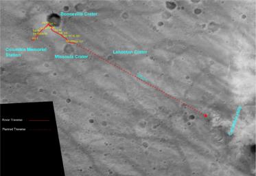
This overview map made from Mars Orbiter camera images illustrates the path that the Mars Exploration Rover Spirit has taken from its first sol on the red planet through its 107th sol. As of sol 112 (April 26, 2004), Spirit has passed "Missoula" crater and sits approximately 1,900 meters (1.18 miles) away from its destination at the western base of the "Columbia Hills." While most of Spirit's journey has been over the very angular rocks that make up the ejecta fields surrounding "Bonneville" crater, the rover's next 50 or so sols will be spent traversing over martian plains that are dominated by rounder, vesicle-filled rocks.


Signaler ce message à un modérateur | IP: Logguée
Temps en ligne : 8 Jours, 15 Heures, 44 Minutes, 21 Secondes en ligne

Old Post 30-04-2004 03:27
Cliquez ici pour voir le profil de Seth Cliquez ici pour lui envoyer un message privé  Trouver plus de messages de Seth Ajouter Seth à votre liste d'amis Editer/Effacer le Message Citer le message dans la réponse
 Seth  Rechercher tous les messages de ce membre Cliquez ici pour envoyer un message privé à cet utilisateur
Confirmé

Déconnecté

Niveau : 3
N° de Membre : 1512

Ancienneté : 100%
Participation : 2%
Inscription: 07 May 2002
Localisation:
Messages: 1390
Sujets Lancés : 70


http://photojournal.jpl.nasa.gov/jp...5824_modest.jpg
PIA05824.tif (3.76 MB) http://photojournal.jpl.nasa.gov/tiff/PIA05824.tif

Citation:
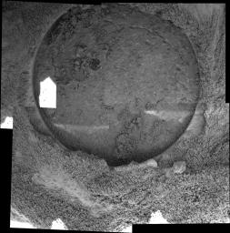
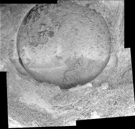
This mosaic of five images taken by the microscopic imager on the Mars Exploration Rover Opportunity on sol 87 shows the hole drilled by the rover's rock abrasion tool into the rock dubbed "Pilbara." A sliced "blueberry," or spherule, which is darker and harder than the rest of the rock, can be seen near the center of the hole. The rock abrasion process left a pile of rock powder around the side of the hole, and to a lesser degree, inside the hole. The hole is 7.2 millimeters (about 0.28 inches) deep and 4.5 centimeters (about 1.8 inches) in diameter.

Because the original images of this hole had areas of bright sunlight as well as shadow, the images making up this mosaic have been arranged to hide as much of the sunlit area as possible. The white spot is one area that could not be covered by other images. It is possible to stretch the image so that features in this white spot are visible, but this makes the rest of the mosaic harder to view. The bright streaks on the bottom part of the hole are most likely reflections from various parts of the robotic arm. The geometric and brightness seams have been corrected in this image.


Signaler ce message à un modérateur | IP: Logguée
Temps en ligne : 8 Jours, 15 Heures, 44 Minutes, 21 Secondes en ligne

Old Post 30-04-2004 03:29
Cliquez ici pour voir le profil de Seth Cliquez ici pour lui envoyer un message privé  Trouver plus de messages de Seth Ajouter Seth à votre liste d'amis Editer/Effacer le Message Citer le message dans la réponse
 Seth  Rechercher tous les messages de ce membre Cliquez ici pour envoyer un message privé à cet utilisateur
Confirmé

Déconnecté

Niveau : 3
N° de Membre : 1512

Ancienneté : 100%
Participation : 2%
Inscription: 07 May 2002
Localisation:
Messages: 1390
Sujets Lancés : 70


http://photojournal.jpl.nasa.gov/jp...5825_modest.jpg
PIA05825.tif (636.4 kB) http://photojournal.jpl.nasa.gov/tiff/PIA05825.tif

Citation:
This overview map made from images taken by the camera on the Mars Global Surveyor orbiter illustrates the path that the Mars Exploration Rover Opportunity has taken from its first sol on the red planet through its 91st sol. After thoroughly examining its "Eagle Crater" landing-site, the rover moved onto the plains of Meridiani Planum, stopping to examine a curious trough and a target within it called "Anatolia." Following that, Opportunity approached and remotely studied the rocky dish called "Fram Crater." As of its 91st sol (April 26, 2004), the rover has traveled about 811 meters (.5 miles) and currently sits about 160 meters (525 feet) from the rim of its next target, "Endurance Crater."


Signaler ce message à un modérateur | IP: Logguée
Temps en ligne : 8 Jours, 15 Heures, 44 Minutes, 21 Secondes en ligne

Old Post 30-04-2004 03:30
Cliquez ici pour voir le profil de Seth Cliquez ici pour lui envoyer un message privé  Trouver plus de messages de Seth Ajouter Seth à votre liste d'amis Editer/Effacer le Message Citer le message dans la réponse
 Seth  Rechercher tous les messages de ce membre Cliquez ici pour envoyer un message privé à cet utilisateur
Confirmé

Déconnecté

Niveau : 3
N° de Membre : 1512

Ancienneté : 100%
Participation : 2%
Inscription: 07 May 2002
Localisation:
Messages: 1390
Sujets Lancés : 70


http://photojournal.jpl.nasa.gov/jp...5826_modest.jpg
PIA05826.jpg (67.19 kB) http://photojournal.jpl.nasa.gov/jpeg/PIA05826.jpg

Citation:
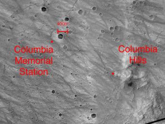
This image highlights the beginning--the Columbia Memorial Station--and possible end - the "Columbia Hills" - of the Mars Exploration Rover Spirit's journey. The image was taken by the camera on NASA's Mars Global Surveyor orbiter.


Signaler ce message à un modérateur | IP: Logguée
Temps en ligne : 8 Jours, 15 Heures, 44 Minutes, 21 Secondes en ligne

Old Post 30-04-2004 03:31
Cliquez ici pour voir le profil de Seth Cliquez ici pour lui envoyer un message privé  Trouver plus de messages de Seth Ajouter Seth à votre liste d'amis Editer/Effacer le Message Citer le message dans la réponse
 Solacin  Rechercher tous les messages de ce membre Cliquez ici pour envoyer un message privé à cet utilisateur
Guru

Déconnecté

Niveau : 5
N° de Membre : 11117

Ancienneté : 96%
Participation : 10%
Inscription: 23 Mar 2003
Localisation: 974
Age: 52
Messages: 8253
Sujets Lancés : 28

Fin des missions de nos 2 robots .......... par contre, j'espére que les images vont continuer elles


__________________


Signaler ce message à un modérateur | IP: Logguée
Temps en ligne : 25 Jours, 5 Heures, 18 Minutes, 53 Secondes en ligne

Old Post 30-04-2004 05:26
Cliquez ici pour voir le profil de Solacin Cliquez ici pour lui envoyer un message privé  Trouver plus de messages de Solacin Ajouter Solacin à votre liste d'amis       Editer/Effacer le Message Citer le message dans la réponse
 Seth  Rechercher tous les messages de ce membre Cliquez ici pour envoyer un message privé à cet utilisateur
Confirmé

Déconnecté

Niveau : 3
N° de Membre : 1512

Ancienneté : 100%
Participation : 2%
Inscription: 07 May 2002
Localisation:
Messages: 1390
Sujets Lancés : 70

Citation:
Message écrit par Solacin, le 30-04-2004 à 14:26
Fin des missions de nos 2 robots .......... par contre, j'espére que les images vont continuer elles


Oui, il y a encore beaucoup de photos...


Signaler ce message à un modérateur | IP: Logguée
Temps en ligne : 8 Jours, 15 Heures, 44 Minutes, 21 Secondes en ligne

Old Post 30-04-2004 05:50
Cliquez ici pour voir le profil de Seth Cliquez ici pour lui envoyer un message privé  Trouver plus de messages de Seth Ajouter Seth à votre liste d'amis Editer/Effacer le Message Citer le message dans la réponse
 Seth  Rechercher tous les messages de ce membre Cliquez ici pour envoyer un message privé à cet utilisateur
Confirmé

Déconnecté

Niveau : 3
N° de Membre : 1512

Ancienneté : 100%
Participation : 2%
Inscription: 07 May 2002
Localisation:
Messages: 1390
Sujets Lancés : 70


http://photojournal.jpl.nasa.gov/jp...5827_modest.jpg
PIA05827.tif (5.843 MB) http://photojournal.jpl.nasa.gov/tiff/PIA05827.tif

Citation:
This 360-degree panorama taken by the navigation camera on the Mars Exploration Rover Spirit highlights the bumpy terrain surrounding the rover. Spirit's shadow can be seen in a small hollow lying between the rover and its intended target, the eastern-lying "Columbia Hills." Spirit's longest drive so far covered about 88.5 meters (about 290 feet) and took place on sol 113. This image was taken on sol 112 (April 26, 2004).


Signaler ce message à un modérateur | IP: Logguée
Temps en ligne : 8 Jours, 15 Heures, 44 Minutes, 21 Secondes en ligne

Old Post 30-04-2004 05:52
Cliquez ici pour voir le profil de Seth Cliquez ici pour lui envoyer un message privé  Trouver plus de messages de Seth Ajouter Seth à votre liste d'amis Editer/Effacer le Message Citer le message dans la réponse
 Seth  Rechercher tous les messages de ce membre Cliquez ici pour envoyer un message privé à cet utilisateur
Confirmé

Déconnecté

Niveau : 3
N° de Membre : 1512

Ancienneté : 100%
Participation : 2%
Inscription: 07 May 2002
Localisation:
Messages: 1390
Sujets Lancés : 70


http://photojournal.jpl.nasa.gov/jp...5828_modest.jpg
PIA05828.tif (6.672 MB) http://photojournal.jpl.nasa.gov/tiff/PIA05828.tif

Citation:
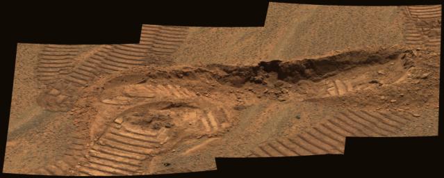
This approximate true-color image mosaic from the panoramic camera on the Mars Exploration Rover Opportunity shows a trench dug by the rover in the vicinity of the "Anatolia" region. Two imprints from the rover's Mossbauer spectrometer instrument were left in the exposed soils. Detailed comparisons between soils exposed at the surface and those found at depth reveal that surface soils have higher levels of hematite while subsurface soils show fine particles derived from basalt. The trench is approximately 11 centimeters deep. This image was taken on sol 81 with the panoramic camera's 430-, 530- and 750-nanometer filters.


Signaler ce message à un modérateur | IP: Logguée
Temps en ligne : 8 Jours, 15 Heures, 44 Minutes, 21 Secondes en ligne

Old Post 30-04-2004 05:54
Cliquez ici pour voir le profil de Seth Cliquez ici pour lui envoyer un message privé  Trouver plus de messages de Seth Ajouter Seth à votre liste d'amis Editer/Effacer le Message Citer le message dans la réponse
 Seth  Rechercher tous les messages de ce membre Cliquez ici pour envoyer un message privé à cet utilisateur
Confirmé

Déconnecté

Niveau : 3
N° de Membre : 1512

Ancienneté : 100%
Participation : 2%
Inscription: 07 May 2002
Localisation:
Messages: 1390
Sujets Lancés : 70


http://photojournal.jpl.nasa.gov/jp...5829_modest.jpg
PIA05829.tif (1.571 MB) http://photojournal.jpl.nasa.gov/tiff/PIA05829.tif

Citation:
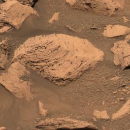
This approximate true-color image taken by the panoramic camera on the Mars Exploration Rover Opportunity show the rock called "Pilbara" located in the small crater dubbed "Fram." The rock appears to be dotted with the same "blueberries," or spherules, found at "Eagle Crater." Spirit drilled into this rock with its rock abrasion tool. After analyzing the hole with the rover's scientific instruments, scientists concluded that Pilbara has a similar chemical make-up, and thus watery past, to rocks studied at Eagle Crater. This image was taken with the panoramic camera's 480-, 530- and 600-nanometer filters.


Signaler ce message à un modérateur | IP: Logguée
Temps en ligne : 8 Jours, 15 Heures, 44 Minutes, 21 Secondes en ligne

Old Post 30-04-2004 05:55
Cliquez ici pour voir le profil de Seth Cliquez ici pour lui envoyer un message privé  Trouver plus de messages de Seth Ajouter Seth à votre liste d'amis Editer/Effacer le Message Citer le message dans la réponse
 Seth  Rechercher tous les messages de ce membre Cliquez ici pour envoyer un message privé à cet utilisateur
Confirmé

Déconnecté

Niveau : 3
N° de Membre : 1512

Ancienneté : 100%
Participation : 2%
Inscription: 07 May 2002
Localisation:
Messages: 1390
Sujets Lancés : 70


http://photojournal.jpl.nasa.gov/jp...5830_modest.jpg
PIA05830.tif (1.575 MB) http://photojournal.jpl.nasa.gov/tiff/PIA05830.tif

Citation:
This approximate true-color image taken by the panoramic camera on the Mars Exploration Rover Opportunity show the hole drilled into the rock called "Pilbara," which is located in the small crater dubbed "Fram." Spirit drilled into this rock with its rock abrasion tool. The rock appears to be dotted with the same "blueberries," or spherules, found at "Eagle Crater." After analyzing the hole with the rover's scientific instruments, scientists concluded that Pilbara has a similar chemical make-up, and thus watery past, to rocks studied at Eagle Crater. This image was taken with the panoramic camera's 480-, 530- and 600-nanometer filters.


http://photojournal.jpl.nasa.gov/jp...5831_modest.jpg
PIA05831.tif (885.6 kB) http://photojournal.jpl.nasa.gov/tiff/PIA05831.tif

Citation:
This mosaic of five images taken by the microscopic imager on the Mars Exploration Rover Opportunity on sol 87 shows the hole drilled by the rover's rock abrasion tool into the rock dubbed "Pilbara." A sliced "blueberry," or spherule, which is darker and harder than the rest of the rock, can be seen near the center of the hole. The rock abrasion process left a pile of rock powder around the side of the hole, and to a lesser degree, inside the hole. The grinding penetrated an area of rock about 7.2 millimeters (about 0.28 inches) deep and 4.5 centimeters (about 1.8 inches) in diameter.


Signaler ce message à un modérateur | IP: Logguée
Temps en ligne : 8 Jours, 15 Heures, 44 Minutes, 21 Secondes en ligne

Old Post 30-04-2004 05:55
Cliquez ici pour voir le profil de Seth Cliquez ici pour lui envoyer un message privé  Trouver plus de messages de Seth Ajouter Seth à votre liste d'amis Editer/Effacer le Message Citer le message dans la réponse
Il est actuellement 13:45 (GMT) Poster un nouveau sujet    Poster une réponse   
Page(s) (49): [ <<   <   35   36   37   38   39   40   41   42   43   44   45   46   47   48   49   > ]  Sujet précédent   Sujet suivant
Forum OXMO > Section Généraliste > Discussion Libre > Je vous parle en direct de Mars (Opportunity a atterri !)

Aller au Forum:
Notez ce sujet :


 Réponse Rapide
Titre: (Optionnel)
Message:

Convertir automatiquement les URLs Montrer la Signature
Afficher une version imprimable | Envoyer cette page par email | S'inscrire à ce sujet | Télécharger ce sujet
Règles du forum :
Créer de nouveaux sujets
Répondre aux messages
Attacher des fichiers
Editer vos messages
: not autorisé
: not autorisé
: not autorisé
: not autorisé
Le Code HTML est OFF
Le Code vB est ON
Les Smileys sont ONs
Le code [IMG] est ON
 
< Contactez-nous - Forum OXMO>

Uptime du serveur SQL : 2 jour(s) 13 heure(s) et 21 minute(s)
Page générée en 0.013230 secondes en exécutant 42 requêtes SQL.
Apache - Compression GZIP : Activée.