Accueil Foire Aux Questions Trouver d'autres membres Rechercher Utilisez le vBpad pour stocker des notes personnelles Ici, vous pouvez voir les sujets auxquels vous avez souscris, vos messages privés; et modifier vos informations personnelles et préférences. Statistiques du forum Enregistrez vous gratuitement ! Se déconnecter  
Forum OXMO Forum OXMO > Section Généraliste > Discussion Libre > Je vous parle en direct de Mars (Opportunity a atterri !)


Aller au Forum:
Notez ce sujet :

Page(s) (49): [ <<   <   37   38   39   40   41   42   43   44   45   46   47   48   49   > ]   Sujet précédent   Sujet suivant
Auteur
Sujet Poster un nouveau sujet    Poster une réponse
 Seth  Rechercher tous les messages de ce membre Cliquez ici pour envoyer un message privé à cet utilisateur
Confirmé

Déconnecté

Niveau : 3
N° de Membre : 1512

Ancienneté : 100%
Participation : 2%
Inscription: 07 May 2002
Localisation:
Messages: 1390
Sujets Lancés : 70


http://photojournal.jpl.nasa.gov/jp...5844_modest.jpg
PIA05844.tif (1.05 MB) http://photojournal.jpl.nasa.gov/tiff/PIA05844.tif

Citation:
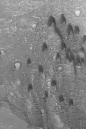
28 April 2004
One of the simplest forms a sand dune can take is the barchan. The term, apparently, comes from the Arabic word for crescent-shaped dunes. They form in areas with a single dominant wind direction that are also not overly-abundant in sand. The barchan dunes shown here were imaged in March 2004 by the Mars Global Surveyor (MGS) Mars Orbiter Camera (MOC) as it passed over a crater in western Arabia Terra near 21.1°N, 17.6°W. The horns and steep slope on each dune, known as the slip face, point toward the south, indicating prevailing winds from the north (top). The picture covers an area about 3 km (1.9 mi) across and is illuminated by sunlight from the lower left


Signaler ce message à un modérateur | IP: Logguée
Temps en ligne : 8 Jours, 15 Heures, 44 Minutes, 21 Secondes en ligne

Old Post 01-05-2004 07:55
Cliquez ici pour voir le profil de Seth Cliquez ici pour lui envoyer un message privé  Trouver plus de messages de Seth Ajouter Seth à votre liste d'amis Editer/Effacer le Message Citer le message dans la réponse
 Seth  Rechercher tous les messages de ce membre Cliquez ici pour envoyer un message privé à cet utilisateur
Confirmé

Déconnecté

Niveau : 3
N° de Membre : 1512

Ancienneté : 100%
Participation : 2%
Inscription: 07 May 2002
Localisation:
Messages: 1390
Sujets Lancés : 70


http://photojournal.jpl.nasa.gov/jp...5846_modest.jpg
PIA05846.tif (4.199 MB) http://photojournal.jpl.nasa.gov/tiff/PIA05846.tif

Citation:
30 April 2004
This Mars Global Surveyor (MGS) Mars Orbiter Camera (MOC) image shows a relatively young impact crater located in southeastern Arabia Terra near 4.8°N, 313.9°W. It is about 1 kilometer (about six tenths of a mile) in diameter, roughly the size of the famous Meteor Crater in northern Arizona, U.S.A. Indeed, the Arizona crater may once have looked very similar to this, but erosion on Earth has been more vigorous than on the modern Mars. Large boulders, many of them bigger than a typical house, can be seen in the ejecta blanket and on the crater floor. Fine, bright dust, common throughout Arabia Terra, has thinly mantled all but the steepest slopes. The image is is illuminated by sunlight from the left/upper left. The picture covers an area about 3 km (1.9 mi) across.


Signaler ce message à un modérateur | IP: Logguée
Temps en ligne : 8 Jours, 15 Heures, 44 Minutes, 21 Secondes en ligne

Old Post 01-05-2004 07:56
Cliquez ici pour voir le profil de Seth Cliquez ici pour lui envoyer un message privé  Trouver plus de messages de Seth Ajouter Seth à votre liste d'amis Editer/Effacer le Message Citer le message dans la réponse
 Seth  Rechercher tous les messages de ce membre Cliquez ici pour envoyer un message privé à cet utilisateur
Confirmé

Déconnecté

Niveau : 3
N° de Membre : 1512

Ancienneté : 100%
Participation : 2%
Inscription: 07 May 2002
Localisation:
Messages: 1390
Sujets Lancés : 70


http://photojournal.jpl.nasa.gov/jp...5847_modest.jpg
PIA05847.tif (2.295 MB) http://photojournal.jpl.nasa.gov/tiff/PIA05847.tif

Citation:
This image mosaic from the Mars Exploration Rover Opportunity's panoramic camera was taken from a rover position approximately 70 meters (about 230 feet) from the rim of "Endurance Crater" on the rover's 93rd sol on Mars. The foreground highlights the now familiar ripples and dimples, common on the plains of Meridiani Planum. Some rock outcrop is seen emerging on the hill to the left, indicating that the rover is driving through the eroded remnants of the crater's ejecta blanket and is getting close to its rim. This light-colored outcrop is probably similar to the rocks seen at "Fram Crater" and "Anatolia," and studied in detail at "Eagle Crater." The Eagle Crater rocks are believed to have been deposited in an open body of water. The science team is intrigued by the darker rock on the far side of the crater wall. Just right of the center, on the far crater wall, rocks appear to form thick, massive layers, suggesting they may have been formed by a different geologic processes than the lighter rocks in the foreground. The greater thickness of layered rocks at Endurance Crater will provide the team with a longer record of geologic processes operating at Meridiani Planum.


Signaler ce message à un modérateur | IP: Logguée
Temps en ligne : 8 Jours, 15 Heures, 44 Minutes, 21 Secondes en ligne

Old Post 01-05-2004 07:58
Cliquez ici pour voir le profil de Seth Cliquez ici pour lui envoyer un message privé  Trouver plus de messages de Seth Ajouter Seth à votre liste d'amis Editer/Effacer le Message Citer le message dans la réponse
 Seth  Rechercher tous les messages de ce membre Cliquez ici pour envoyer un message privé à cet utilisateur
Confirmé

Déconnecté

Niveau : 3
N° de Membre : 1512

Ancienneté : 100%
Participation : 2%
Inscription: 07 May 2002
Localisation:
Messages: 1390
Sujets Lancés : 70


http://photojournal.jpl.nasa.gov/jp...5856_modest.jpg
PIA05856.tif (1.05 MB) http://photojournal.jpl.nasa.gov/tiff/PIA05856.tif

Citation:
1 May 2004
This Mars Global Surveyor (MGS) Mars Orbiter Camera (MOC) image shows frost-covered sand dunes in the early northern spring of 2004 in the north polar region. Sunlight illuminates the dunes from the bottom/lower left, but frost on slopes facing the lower right create the illusion of sunlight from that direction. This dune field, which would appear quite dark in summertime, is located near 80.3°N, 148.7°W. The picture covers an area about 3 km (1.9 mi) across.


Signaler ce message à un modérateur | IP: Logguée
Temps en ligne : 8 Jours, 15 Heures, 44 Minutes, 21 Secondes en ligne

Old Post 06-05-2004 06:35
Cliquez ici pour voir le profil de Seth Cliquez ici pour lui envoyer un message privé  Trouver plus de messages de Seth Ajouter Seth à votre liste d'amis Editer/Effacer le Message Citer le message dans la réponse
 Seth  Rechercher tous les messages de ce membre Cliquez ici pour envoyer un message privé à cet utilisateur
Confirmé

Déconnecté

Niveau : 3
N° de Membre : 1512

Ancienneté : 100%
Participation : 2%
Inscription: 07 May 2002
Localisation:
Messages: 1390
Sujets Lancés : 70


http://photojournal.jpl.nasa.gov/jp...5857_modest.jpg
PIA05857.tif (6.298 MB) http://photojournal.jpl.nasa.gov/tiff/PIA05857.tif

Citation:
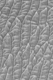
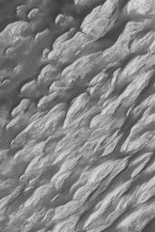
2 May 2004
The "White Rock" of Pollack Crater is a feature that has been known since it was first observed by Mariner 9 in 1972. It is not actually white, but is much brighter than the fields of large, dark, windblown ripples that surround it. This Mars Global Surveyor (MGS) Mars Orbiter Camera (MOC) picture provides the highest resolution view, ever, of a portion of the wind-eroded "White Rock" feature. The rock materials are believed to be the remains of sediment that once covered the floor of Pollack Crater. Wind has sculpted the light-toned material into ridges and troughs known as yardangs. This 1.5 meters per pixel (5 feet per pixel) image is located near 8.1°S, 335.2°W. It was acquired in late March 2004, is illuminated from the left/upper left, and covers an area about 3 km (1.9 mi) across.

An earlier MOC view of "White Rock" can be seen in: "White Rock" of Pollack Crater, 4 December 2000


Signaler ce message à un modérateur | IP: Logguée
Temps en ligne : 8 Jours, 15 Heures, 44 Minutes, 21 Secondes en ligne

Old Post 06-05-2004 06:36
Cliquez ici pour voir le profil de Seth Cliquez ici pour lui envoyer un message privé  Trouver plus de messages de Seth Ajouter Seth à votre liste d'amis Editer/Effacer le Message Citer le message dans la réponse
 Seth  Rechercher tous les messages de ce membre Cliquez ici pour envoyer un message privé à cet utilisateur
Confirmé

Déconnecté

Niveau : 3
N° de Membre : 1512

Ancienneté : 100%
Participation : 2%
Inscription: 07 May 2002
Localisation:
Messages: 1390
Sujets Lancés : 70


http://photojournal.jpl.nasa.gov/jp...5858_modest.jpg
PIA05858.tif (489.1 kB) http://photojournal.jpl.nasa.gov/tiff/PIA05858.tif

Citation:
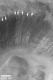
3 May 2004
Martian middle- and polar-latitude gullies are not the only places that 'alcoves' form by downslope erosion of debris. Even at equatorial latitudes, some craters exhibit these features. Alcoves at the heads of narrow, dry landslide scars are indicated in this Mars Global Surveyor (MGS) Mars Orbiter Camera (MOC) image of a crater wall in Xanthe Terra. In both the middle/polar-latitude gully cases and in this example, alcoves form by undermining and collapse of material high on a relatively steep slope such as a crater wall. In this case, however, no fluid was involved, thus no gully or distinct apron formed. This crater wall is located near Shalbatana Vallis around 2.7°N, 43.1°W. The image is illuminated from the left; the 400 meter scale bar is about 437 yards long. For comparison, an example of martian gullies with alcoves, channels, and aprons can be seen in: Evidence for Recent Liquid Water on Mars: Basic Features of Martian Gullies, 22 June 2000


Signaler ce message à un modérateur | IP: Logguée
Temps en ligne : 8 Jours, 15 Heures, 44 Minutes, 21 Secondes en ligne

Old Post 06-05-2004 06:37
Cliquez ici pour voir le profil de Seth Cliquez ici pour lui envoyer un message privé  Trouver plus de messages de Seth Ajouter Seth à votre liste d'amis Editer/Effacer le Message Citer le message dans la réponse
 Seth  Rechercher tous les messages de ce membre Cliquez ici pour envoyer un message privé à cet utilisateur
Confirmé

Déconnecté

Niveau : 3
N° de Membre : 1512

Ancienneté : 100%
Participation : 2%
Inscription: 07 May 2002
Localisation:
Messages: 1390
Sujets Lancés : 70


http://photojournal.jpl.nasa.gov/jp...5864_modest.jpg
PIA05864.tif (1.482 MB) http://photojournal.jpl.nasa.gov/tiff/PIA05864.tif


Citation:


Released 3 May 2004

This nighttime visible color image was collected on January 1, 2003 during the Northern Summer season near the North Polar Troughs.

This daytime visible color image was collected on September 4, 2002 during the Northern Spring season in Vastitas Borealis. The THEMIS VIS camera is capable of capturing color images of the martian surface using its five different color filters. In this mode of operation, the spatial resolution and coverage of the image must be reduced to accommodate the additional data volume produced from the use of multiple filters. To make a color image, three of the five filter images (each in grayscale) are selected. Each is contrast enhanced and then converted to a red, green, or blue intensity image. These three images are then combined to produce a full color, single image. Because the THEMIS color filters don't span the full range of colors seen by the human eye, a color THEMIS image does not represent true color. Also, because each single-filter image is contrast enhanced before inclusion in the three-color image, the apparent color variation of the scene is exaggerated. Nevertheless, the color variation that does appear is representative of some change in color, however subtle, in the actual scene. Note that the long edges of THEMIS color images typically contain color artifacts that do not represent surface variation.

Image information: VIS instrument. Latitude 79, Longitude 346 East (14 West). 19 meter/pixel resolution.

Note: this THEMIS visual image has not been radiometrically nor geometrically calibrated for this preliminary release. An empirical correction has been performed to remove instrumental effects. A linear shift has been applied in the cross-track and down-track direction to approximate spacecraft and planetary motion. Fully calibrated and geometrically projected images will be released through the Planetary Data System in accordance with Project policies at a later time.

NASA's Jet Propulsion Laboratory manages the 2001 Mars Odyssey mission for NASA's Office of Space Science, Washington, D.C. The Thermal Emission Imaging System (THEMIS) was developed by Arizona State University, Tempe, in collaboration with Raytheon Santa Barbara Remote Sensing. The THEMIS investigation is led by Dr. Philip Christensen at Arizona State University. Lockheed Martin Astronautics, Denver, is the prime contractor for the Odyssey project, and developed and built the orbiter. Mission operations are conducted jointly from Lockheed Martin and from JPL, a division of the California Institute of Technology in Pasadena.


Signaler ce message à un modérateur | IP: Logguée
Temps en ligne : 8 Jours, 15 Heures, 44 Minutes, 21 Secondes en ligne

Old Post 06-05-2004 06:38
Cliquez ici pour voir le profil de Seth Cliquez ici pour lui envoyer un message privé  Trouver plus de messages de Seth Ajouter Seth à votre liste d'amis Editer/Effacer le Message Citer le message dans la réponse
 Seth  Rechercher tous les messages de ce membre Cliquez ici pour envoyer un message privé à cet utilisateur
Confirmé

Déconnecté

Niveau : 3
N° de Membre : 1512

Ancienneté : 100%
Participation : 2%
Inscription: 07 May 2002
Localisation:
Messages: 1390
Sujets Lancés : 70


http://photojournal.jpl.nasa.gov/jp...5849_modest.jpg
PIA05849.tif (5.902 MB) http://photojournal.jpl.nasa.gov/tiff/PIA05849.tif

Citation:
This three-dimensional, cylindrical-perspective projection was constructed from images taken by the Mars Exploration Rover Opportunity's navigation camera on the rover's 93rd sol on Mars. The camera acquired the images at approximately 12:27 Local Solar Time, or around 8:22 AM Pacific Daylight Time on April 28, 2004. On that sol, Opportunity sat about 75 meters (246 feet) away from the rim of "Endurance Crater."


Signaler ce message à un modérateur | IP: Logguée
Temps en ligne : 8 Jours, 15 Heures, 44 Minutes, 21 Secondes en ligne

Old Post 06-05-2004 06:39
Cliquez ici pour voir le profil de Seth Cliquez ici pour lui envoyer un message privé  Trouver plus de messages de Seth Ajouter Seth à votre liste d'amis Editer/Effacer le Message Citer le message dans la réponse
 Seth  Rechercher tous les messages de ce membre Cliquez ici pour envoyer un message privé à cet utilisateur
Confirmé

Déconnecté

Niveau : 3
N° de Membre : 1512

Ancienneté : 100%
Participation : 2%
Inscription: 07 May 2002
Localisation:
Messages: 1390
Sujets Lancés : 70


http://photojournal.jpl.nasa.gov/jp...5848_modest.jpg
PIA05848.tif (2.013 MB) http://photojournal.jpl.nasa.gov/tiff/PIA05848.tif

Citation:
This cylindrical projection was constructed from three images taken by the Mars Exploration Rover Opportunity's navigation camera on the rover's 93rd sol on Mars. The camera acquired the images at approximately 12:27 Local Solar Time, or around 8:22 AM Pacific Daylight Time on April 28, 2004. On that sol, Opportunity sat about 75 meters (246 feet) away from the rim of "Endurance Crater."


Signaler ce message à un modérateur | IP: Logguée
Temps en ligne : 8 Jours, 15 Heures, 44 Minutes, 21 Secondes en ligne

Old Post 06-05-2004 06:40
Cliquez ici pour voir le profil de Seth Cliquez ici pour lui envoyer un message privé  Trouver plus de messages de Seth Ajouter Seth à votre liste d'amis Editer/Effacer le Message Citer le message dans la réponse
 Seth  Rechercher tous les messages de ce membre Cliquez ici pour envoyer un message privé à cet utilisateur
Confirmé

Déconnecté

Niveau : 3
N° de Membre : 1512

Ancienneté : 100%
Participation : 2%
Inscription: 07 May 2002
Localisation:
Messages: 1390
Sujets Lancés : 70


http://photojournal.jpl.nasa.gov/jp...5850_modest.jpg
PIA05850.tif (2.145 MB) http://photojournal.jpl.nasa.gov/tiff/PIA05850.tif

Citation:
This cylindrical-perspective projection was constructed from a sequence of images taken by the Mars Exploration Rover Opportunity's navigation camera on the rover's 93rd sol on Mars. The mosaic was created from three images from the camera's left eye. The camera acquired the images at approximately 12:27 Local Solar Time, or around 8:22 AM Pacific Daylight Time on April 28, 2004. On that sol, Opportunity sat about 75 meters (246 feet) away from the rim of "Endurance Crater."


Signaler ce message à un modérateur | IP: Logguée
Temps en ligne : 8 Jours, 15 Heures, 44 Minutes, 21 Secondes en ligne

Old Post 06-05-2004 06:41
Cliquez ici pour voir le profil de Seth Cliquez ici pour lui envoyer un message privé  Trouver plus de messages de Seth Ajouter Seth à votre liste d'amis Editer/Effacer le Message Citer le message dans la réponse
 Seth  Rechercher tous les messages de ce membre Cliquez ici pour envoyer un message privé à cet utilisateur
Confirmé

Déconnecté

Niveau : 3
N° de Membre : 1512

Ancienneté : 100%
Participation : 2%
Inscription: 07 May 2002
Localisation:
Messages: 1390
Sujets Lancés : 70


http://photojournal.jpl.nasa.gov/jp...5851_modest.jpg
PIA05851.tif (2.207 MB) http://photojournal.jpl.nasa.gov/tiff/PIA05851.tif

Citation:
This cylindrical-perspective projection was constructed from a sequence of images taken by the Mars Exploration Rover Opportunity's navigation camera on the rover's 93rd sol on Mars. The mosaic was created from three images from the camera's right eye. The camera acquired the images at approximately 12:27 Local Solar Time, or around 8:22 AM Pacific Daylight Time on April 28, 2004. On that sol, Opportunity sat about 75 meters (246 feet) away from the rim of "Endurance Crater."


Signaler ce message à un modérateur | IP: Logguée
Temps en ligne : 8 Jours, 15 Heures, 44 Minutes, 21 Secondes en ligne

Old Post 06-05-2004 06:43
Cliquez ici pour voir le profil de Seth Cliquez ici pour lui envoyer un message privé  Trouver plus de messages de Seth Ajouter Seth à votre liste d'amis Editer/Effacer le Message Citer le message dans la réponse
 Seth  Rechercher tous les messages de ce membre Cliquez ici pour envoyer un message privé à cet utilisateur
Confirmé

Déconnecté

Niveau : 3
N° de Membre : 1512

Ancienneté : 100%
Participation : 2%
Inscription: 07 May 2002
Localisation:
Messages: 1390
Sujets Lancés : 70


http://photojournal.jpl.nasa.gov/jp...5852_modest.jpg
PIA05852.tif (2.234 MB) http://photojournal.jpl.nasa.gov/tiff/PIA05852.tif

Citation:
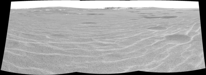
This cylindrical projection was constructed from a sequence of three images taken by the navigation camera on the Mars Exploration Rover Opportunity. The images were acquired on sol 94 (April 29, 2004) of Opportunity's mission to Meridiani Planum. The camera acquired the images at approximately 12:40 local solar time, or around 9:15 a.m. Pacific Daylight Time. The images were taken from the rover's new location about 20 meters (65 feet) away from the rim of Opportunity's next target, "Endurance Crater."


Signaler ce message à un modérateur | IP: Logguée
Temps en ligne : 8 Jours, 15 Heures, 44 Minutes, 21 Secondes en ligne

Old Post 07-05-2004 00:57
Cliquez ici pour voir le profil de Seth Cliquez ici pour lui envoyer un message privé  Trouver plus de messages de Seth Ajouter Seth à votre liste d'amis Editer/Effacer le Message Citer le message dans la réponse
 Seth  Rechercher tous les messages de ce membre Cliquez ici pour envoyer un message privé à cet utilisateur
Confirmé

Déconnecté

Niveau : 3
N° de Membre : 1512

Ancienneté : 100%
Participation : 2%
Inscription: 07 May 2002
Localisation:
Messages: 1390
Sujets Lancés : 70


http://photojournal.jpl.nasa.gov/jp...5853_modest.jpg
PIA05853.tif (5.951 MB) http://photojournal.jpl.nasa.gov/tiff/PIA05853.tif

Citation:
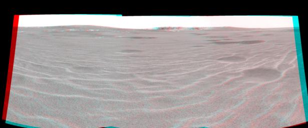
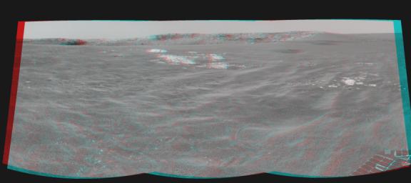
This three-dimensional, cylindrical-perspective projection was constructed from images taken by the navigation camera on the Mars Exploration Rover Opportunity. The images were acquired on sol 94 (April 29, 2004) of Opportunity's mission to Meridiani Planum. The camera acquired the images at approximately 12:40 local solar time, or around 9:15 a.m. Pacific Daylight Time. The images were taken from the rover's new location about 20 meters (65 feet) away from the rim of Opportunity's next target, "Endurance Crater."


Signaler ce message à un modérateur | IP: Logguée
Temps en ligne : 8 Jours, 15 Heures, 44 Minutes, 21 Secondes en ligne

Old Post 07-05-2004 00:58
Cliquez ici pour voir le profil de Seth Cliquez ici pour lui envoyer un message privé  Trouver plus de messages de Seth Ajouter Seth à votre liste d'amis Editer/Effacer le Message Citer le message dans la réponse
 Seth  Rechercher tous les messages de ce membre Cliquez ici pour envoyer un message privé à cet utilisateur
Confirmé

Déconnecté

Niveau : 3
N° de Membre : 1512

Ancienneté : 100%
Participation : 2%
Inscription: 07 May 2002
Localisation:
Messages: 1390
Sujets Lancés : 70


http://photojournal.jpl.nasa.gov/jp...5854_modest.jpg
PIA05854.tif (2.145 MB) http://photojournal.jpl.nasa.gov/tiff/PIA05854.tif

Citation:
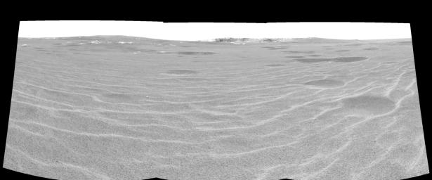
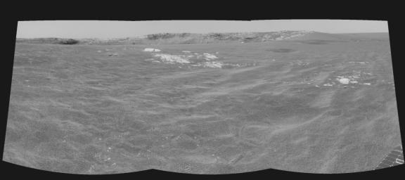
This cylindrical-perspective projection was constructed from a sequence of three images taken by the left navigation camera on the Mars Exploration Rover Opportunity. The images were acquired on sol 94 (April 29, 2004) of Opportunity's mission to Meridiani Planum. The camera acquired the images at approximately 12:40 local solar time, or around 9:15 a.m. Pacific Daylight Time. The images were taken from the rover's new location about 20 meters (65 feet) away from the rim of Opportunity's next target, "Endurance Crater."


Signaler ce message à un modérateur | IP: Logguée
Temps en ligne : 8 Jours, 15 Heures, 44 Minutes, 21 Secondes en ligne

Old Post 07-05-2004 00:59
Cliquez ici pour voir le profil de Seth Cliquez ici pour lui envoyer un message privé  Trouver plus de messages de Seth Ajouter Seth à votre liste d'amis Editer/Effacer le Message Citer le message dans la réponse
 Seth  Rechercher tous les messages de ce membre Cliquez ici pour envoyer un message privé à cet utilisateur
Confirmé

Déconnecté

Niveau : 3
N° de Membre : 1512

Ancienneté : 100%
Participation : 2%
Inscription: 07 May 2002
Localisation:
Messages: 1390
Sujets Lancés : 70


http://photojournal.jpl.nasa.gov/jp...5855_modest.jpg
PIA05854.tif (2.145 MB) http://photojournal.jpl.nasa.gov/tiff/PIA05855.tif

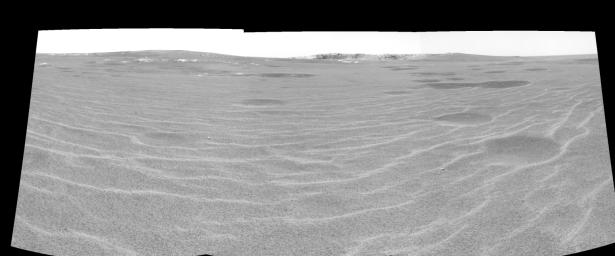
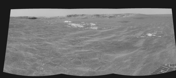
[QUOTE]This cylindrical-perspective projection was constructed from a sequence of three images taken by the left navigation camera on the Mars Exploration Rover Opportunity. The images were acquired on sol 94 (April 29, 2004) of Opportunity's mission to Meridiani Planum. The camera acquired the images at approximately 12:40 local solar time, or around 9:15 a.m. Pacific Daylight Time. The images were taken from the rover's new location about 20 meters (65 feet) away from the rim of Opportunity's next target, "Endurance Crater."[/QUOTE


Signaler ce message à un modérateur | IP: Logguée
Temps en ligne : 8 Jours, 15 Heures, 44 Minutes, 21 Secondes en ligne

Old Post 07-05-2004 00:59
Cliquez ici pour voir le profil de Seth Cliquez ici pour lui envoyer un message privé  Trouver plus de messages de Seth Ajouter Seth à votre liste d'amis Editer/Effacer le Message Citer le message dans la réponse
Il est actuellement 12:26 (GMT) Poster un nouveau sujet    Poster une réponse   
Page(s) (49): [ <<   <   37   38   39   40   41   42   43   44   45   46   47   48   49   > ]  Sujet précédent   Sujet suivant
Forum OXMO > Section Généraliste > Discussion Libre > Je vous parle en direct de Mars (Opportunity a atterri !)

Aller au Forum:
Notez ce sujet :


 Réponse Rapide
Titre: (Optionnel)
Message:

Convertir automatiquement les URLs Montrer la Signature
Afficher une version imprimable | Envoyer cette page par email | S'inscrire à ce sujet | Télécharger ce sujet
Règles du forum :
Créer de nouveaux sujets
Répondre aux messages
Attacher des fichiers
Editer vos messages
: not autorisé
: not autorisé
: not autorisé
: not autorisé
Le Code HTML est OFF
Le Code vB est ON
Les Smileys sont ONs
Le code [IMG] est ON
 
< Contactez-nous - Forum OXMO>

Uptime du serveur SQL : 2 jour(s) 12 heure(s) et 2 minute(s)
Page générée en 0.025274 secondes en exécutant 42 requêtes SQL.
Apache - Compression GZIP : Activée.