Accueil Foire Aux Questions Trouver d'autres membres Rechercher Utilisez le vBpad pour stocker des notes personnelles Ici, vous pouvez voir les sujets auxquels vous avez souscris, vos messages privés; et modifier vos informations personnelles et préférences. Statistiques du forum Enregistrez vous gratuitement ! Se déconnecter  
Forum OXMO Forum OXMO > Section Généraliste > Discussion Libre > Je vous parle en direct de Mars (Opportunity a atterri !)


Aller au Forum:
Notez ce sujet :

Page(s) (49): [ <<   <   38   39   40   41   42   43   44   45   46   47   48   49   > ]   Sujet précédent   Sujet suivant
Auteur
Sujet Poster un nouveau sujet    Poster une réponse
 Seth  Rechercher tous les messages de ce membre Cliquez ici pour envoyer un message privé à cet utilisateur
Confirmé

Déconnecté

Niveau : 3
N° de Membre : 1512

Ancienneté : 100%
Participation : 2%
Inscription: 07 May 2002
Localisation:
Messages: 1390
Sujets Lancés : 70


http://photojournal.jpl.nasa.gov/jp...5859_modest.jpg
PIA05859.tif (3.247 MB) http://photojournal.jpl.nasa.gov/tiff/PIA05859.tif

Citation:
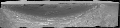
This 180-degree view from the navigation camera on the Mars Exploration Rover Opportunity is the first look inside "Endurance Crater." The view is a cylindrical projection constructed from four images. The crater is about 130 meters (about 430 feet) in diameter.


Signaler ce message à un modérateur | IP: Logguée
Temps en ligne : 8 Jours, 15 Heures, 44 Minutes, 21 Secondes en ligne

Old Post 07-05-2004 01:01
Cliquez ici pour voir le profil de Seth Cliquez ici pour lui envoyer un message privé  Trouver plus de messages de Seth Ajouter Seth à votre liste d'amis Editer/Effacer le Message Citer le message dans la réponse
 Seth  Rechercher tous les messages de ce membre Cliquez ici pour envoyer un message privé à cet utilisateur
Confirmé

Déconnecté

Niveau : 3
N° de Membre : 1512

Ancienneté : 100%
Participation : 2%
Inscription: 07 May 2002
Localisation:
Messages: 1390
Sujets Lancés : 70


http://photojournal.jpl.nasa.gov/jp...5860_modest.jpg
PIA05860.tif (10.09 MB) http://photojournal.jpl.nasa.gov/tiff/PIA05860.tif

Citation:
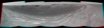
This three-dimensional, 180-degree view from the navigation camera on the Mars Exploration Rover Opportunity is the first look inside "Endurance Crater." The view is a cylindrical-perspective projection constructed from four images. The crater is about 130 meters (about 430 feet) in diameter.


Signaler ce message à un modérateur | IP: Logguée
Temps en ligne : 8 Jours, 15 Heures, 44 Minutes, 21 Secondes en ligne

Old Post 07-05-2004 02:45
Cliquez ici pour voir le profil de Seth Cliquez ici pour lui envoyer un message privé  Trouver plus de messages de Seth Ajouter Seth à votre liste d'amis Editer/Effacer le Message Citer le message dans la réponse
 Seth  Rechercher tous les messages de ce membre Cliquez ici pour envoyer un message privé à cet utilisateur
Confirmé

Déconnecté

Niveau : 3
N° de Membre : 1512

Ancienneté : 100%
Participation : 2%
Inscription: 07 May 2002
Localisation:
Messages: 1390
Sujets Lancés : 70


http://photojournal.jpl.nasa.gov/jp...5861_modest.jpg
PIA05861.tif (3.566 MB) http://photojournal.jpl.nasa.gov/tiff/PIA05861.tif

Citation:
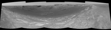
This 180-degree view from the left navigation camera on the Mars Exploration Rover Opportunity is the first look inside "Endurance Crater." The view is a cylindrical-perspective projection constructed from four images. The crater is about 130 meters (about 430 feet) in diameter.


Signaler ce message à un modérateur | IP: Logguée
Temps en ligne : 8 Jours, 15 Heures, 44 Minutes, 21 Secondes en ligne

Old Post 07-05-2004 02:46
Cliquez ici pour voir le profil de Seth Cliquez ici pour lui envoyer un message privé  Trouver plus de messages de Seth Ajouter Seth à votre liste d'amis Editer/Effacer le Message Citer le message dans la réponse
 Seth  Rechercher tous les messages de ce membre Cliquez ici pour envoyer un message privé à cet utilisateur
Confirmé

Déconnecté

Niveau : 3
N° de Membre : 1512

Ancienneté : 100%
Participation : 2%
Inscription: 07 May 2002
Localisation:
Messages: 1390
Sujets Lancés : 70


http://photojournal.jpl.nasa.gov/jp...5862_modest.jpg
PIA05861.tif (3.566 MB) http://photojournal.jpl.nasa.gov/tiff/PIA05862.tif

Citation:
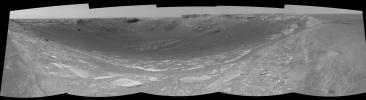
This 180-degree view from the left navigation camera on the Mars Exploration Rover Opportunity is the first look inside "Endurance Crater." The view is a cylindrical-perspective projection constructed from four images. The crater is about 130 meters (about 430 feet) in diameter.


Signaler ce message à un modérateur | IP: Logguée
Temps en ligne : 8 Jours, 15 Heures, 44 Minutes, 21 Secondes en ligne

Old Post 07-05-2004 02:46
Cliquez ici pour voir le profil de Seth Cliquez ici pour lui envoyer un message privé  Trouver plus de messages de Seth Ajouter Seth à votre liste d'amis Editer/Effacer le Message Citer le message dans la réponse
 Seth  Rechercher tous les messages de ce membre Cliquez ici pour envoyer un message privé à cet utilisateur
Confirmé

Déconnecté

Niveau : 3
N° de Membre : 1512

Ancienneté : 100%
Participation : 2%
Inscription: 07 May 2002
Localisation:
Messages: 1390
Sujets Lancés : 70


http://photojournal.jpl.nasa.gov/jp...5865_modest.jpg
PIA05865.tif (492 kB) http://photojournal.jpl.nasa.gov/tiff/PIA05865.tif

Citation:
4 May 2004
In recent weeks, the Mars Global Surveyor (MGS) Mars Orbiter Camera (MOC) blue wide angle images have been showing clouds high in the atmosphere over the Mars Exploration Rover (MER-B), Opportunity, landing site in Meridiani Planum. This view of the sunward limb of Mars shows an example. It was acquired by the MOC blue camera late last week on 29 April 2004. The "x" shows the location of the rover site. The bright features in this image are water ice clouds. The dark portion of the image on the left is outer space. Clouds can also be seen in a zone approximately 20 to 40 kilometers (12-25 miles) above the martian limb. North is approximately up, east is toward the right, and sunlight illuminates the scene from the left (west). The image runs along the limb from about latitudes 4°S to about 2°N.


Signaler ce message à un modérateur | IP: Logguée
Temps en ligne : 8 Jours, 15 Heures, 44 Minutes, 21 Secondes en ligne

Old Post 07-05-2004 02:48
Cliquez ici pour voir le profil de Seth Cliquez ici pour lui envoyer un message privé  Trouver plus de messages de Seth Ajouter Seth à votre liste d'amis Editer/Effacer le Message Citer le message dans la réponse
 Seth  Rechercher tous les messages de ce membre Cliquez ici pour envoyer un message privé à cet utilisateur
Confirmé

Déconnecté

Niveau : 3
N° de Membre : 1512

Ancienneté : 100%
Participation : 2%
Inscription: 07 May 2002
Localisation:
Messages: 1390
Sujets Lancés : 70


http://photojournal.jpl.nasa.gov/jp...5866_modest.jpg
PIA05866.tif (2.013 MB) http://photojournal.jpl.nasa.gov/tiff/PIA05866.tif

Citation:
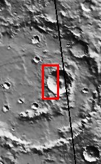

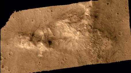
Released 4 May 2004

This daytime visible color image was collected on October 16, 2003 during the Southern Summer season of a crater within Molesworth Crater.

This daytime visible color image was collected on September 4, 2002 during the Northern Spring season in Vastitas Borealis. The THEMIS VIS camera is capable of capturing color images of the martian surface using its five different color filters. In this mode of operation, the spatial resolution and coverage of the image must be reduced to accommodate the additional data volume produced from the use of multiple filters. To make a color image, three of the five filter images (each in grayscale) are selected. Each is contrast enhanced and then converted to a red, green, or blue intensity image. These three images are then combined to produce a full color, single image. Because the THEMIS color filters don't span the full range of colors seen by the human eye, a color THEMIS image does not represent true color. Also, because each single-filter image is contrast enhanced before inclusion in the three-color image, the apparent color variation of the scene is exaggerated. Nevertheless, the color variation that does appear is representative of some change in color, however subtle, in the actual scene. Note that the long edges of THEMIS color images typically contain color artifacts that do not represent surface variation.

Image information: VIS instrument. Latitude -27.4, Longitude 149.6 East (210.4 West). 19 meter/pixel resolution.

Note: this THEMIS visual image has not been radiometrically nor geometrically calibrated for this preliminary release. An empirical correction has been performed to remove instrumental effects. A linear shift has been applied in the cross-track and down-track direction to approximate spacecraft and planetary motion. Fully calibrated and geometrically projected images will be released through the Planetary Data System in accordance with Project policies at a later time.

NASA's Jet Propulsion Laboratory manages the 2001 Mars Odyssey mission for NASA's Office of Space Science, Washington, D.C. The Thermal Emission Imaging System (THEMIS) was developed by Arizona State University, Tempe, in collaboration with Raytheon Santa Barbara Remote Sensing. The THEMIS investigation is led by Dr. Philip Christensen at Arizona State University. Lockheed Martin Astronautics, Denver, is the prime contractor for the Odyssey project, and developed and built the orbiter. Mission operations are conducted jointly from Lockheed Martin and from JPL, a division of the California Institute of Technology in Pasadena.


Signaler ce message à un modérateur | IP: Logguée
Temps en ligne : 8 Jours, 15 Heures, 44 Minutes, 21 Secondes en ligne

Old Post 07-05-2004 02:49
Cliquez ici pour voir le profil de Seth Cliquez ici pour lui envoyer un message privé  Trouver plus de messages de Seth Ajouter Seth à votre liste d'amis Editer/Effacer le Message Citer le message dans la réponse
 Seth  Rechercher tous les messages de ce membre Cliquez ici pour envoyer un message privé à cet utilisateur
Confirmé

Déconnecté

Niveau : 3
N° de Membre : 1512

Ancienneté : 100%
Participation : 2%
Inscription: 07 May 2002
Localisation:
Messages: 1390
Sujets Lancés : 70


http://photojournal.jpl.nasa.gov/jp...5867_modest.jpg
PIA05867.tif (83.53 MB) http://photojournal.jpl.nasa.gov/tiff/PIA05867.tif
PIA05867.jpg (4.324 MB) http://photojournal.jpl.nasa.gov/jpeg/PIA05867.jpg

Citation:
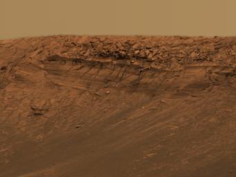
This approximate true-color image taken by the panoramic camera on the Mars Exploration Rover Opportunity shows the impact crater known as "Endurance." Scientists are eager to explore Endurance for clues to the red planet's history. The crater's exposed walls provide a window to what lies beneath the surface of Mars and thus what geologic processes occurred there in the past. While recent studies of the smaller crater nicknamed "Eagle" revealed an evaporating body of salty water, that crater was not deep enough to indicate what came before the water. Endurance may be able to help answer this question, but the challenge is getting to the scientific targets: most of the crater's rocks are embedded in vertical cliffs. Rover planners are currently developing strategies to overcome this obstacle.

Presently, Opportunity is perched 40 centimeters (15.7 inches) away from the crater's edge. Endurance is roughly 130 meters (430 feet) across.

This image mosaic was taken by the panoramic camera's 480-, 530- and 750-nanometer filters on sols 97 and 98. It consists of a total of 258 individual images.


Signaler ce message à un modérateur | IP: Logguée
Temps en ligne : 8 Jours, 15 Heures, 44 Minutes, 21 Secondes en ligne

Old Post 07-05-2004 02:51
Cliquez ici pour voir le profil de Seth Cliquez ici pour lui envoyer un message privé  Trouver plus de messages de Seth Ajouter Seth à votre liste d'amis Editer/Effacer le Message Citer le message dans la réponse
 Seth  Rechercher tous les messages de ce membre Cliquez ici pour envoyer un message privé à cet utilisateur
Confirmé

Déconnecté

Niveau : 3
N° de Membre : 1512

Ancienneté : 100%
Participation : 2%
Inscription: 07 May 2002
Localisation:
Messages: 1390
Sujets Lancés : 70


http://photojournal.jpl.nasa.gov/jp...5869_modest.jpg
PIA05869.tif (652.1 kB) http://photojournal.jpl.nasa.gov/tiff/PIA05869.tif


Citation:
This approximate true-color image taken by the panoramic camera on the Mars Exploration Rover Opportunity highlights a feature called "Burns Cliff" within the impact crater known as "Endurance." Scientists are eager to explore this layered ridge for clues to the red planet's past. The only problem is its location: Burns Cliff is a vertical drop, which poses an interesting challenge for rover planners. Burns Cliff was named after the late scientist Roger Burns, who was one of the first to correctly propose the importance of sulfate and jarosite to the study of Mars' geologic history.

This image is a portion of a larger mosaic taken with the panoramic camera's 480-, 530- and 750-nanometer filters on sols 97 and 98


Signaler ce message à un modérateur | IP: Logguée
Temps en ligne : 8 Jours, 15 Heures, 44 Minutes, 21 Secondes en ligne

Old Post 07-05-2004 02:53
Cliquez ici pour voir le profil de Seth Cliquez ici pour lui envoyer un message privé  Trouver plus de messages de Seth Ajouter Seth à votre liste d'amis Editer/Effacer le Message Citer le message dans la réponse
 Seth  Rechercher tous les messages de ce membre Cliquez ici pour envoyer un message privé à cet utilisateur
Confirmé

Déconnecté

Niveau : 3
N° de Membre : 1512

Ancienneté : 100%
Participation : 2%
Inscription: 07 May 2002
Localisation:
Messages: 1390
Sujets Lancés : 70


http://photojournal.jpl.nasa.gov/jp...5870_modest.jpg
PIA05870.tif (653.6 kB) http://photojournal.jpl.nasa.gov/tiff/PIA05870.tif

Citation:
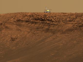
This image shows the approximate size of the Mars Exploration Rover Opportunity in comparison to the impressive impact crater dubbed "Endurance," which is roughly 130 meters (430 feet) across. A model of Opportunity has been superimposed on top of an approximate true-color image taken by the rover's panoramic camera. Scientists are eager to explore Endurance for clues to the red planet's history. The crater's exposed walls provide a window to what lies beneath the surface of Mars and thus what geologic processes occurred there in the past. While recent studies of the smaller crater nicknamed "Eagle" revealed an evaporating body of salty water, that crater was not deep enough to indicate what came before the water. Endurance may be able to help answer this question, but the challenge is getting to the scientific targets: most of the crater's rocks are embedded in vertical cliffs. Rover planners are developing strategies to overcome this obstacle.

This image is a portion of a larger mosaic taken with the panoramic camera's 480-, 530- and 750-nanometer filters on sols 97 and 98.


Signaler ce message à un modérateur | IP: Logguée
Temps en ligne : 8 Jours, 15 Heures, 44 Minutes, 21 Secondes en ligne

Old Post 07-05-2004 02:54
Cliquez ici pour voir le profil de Seth Cliquez ici pour lui envoyer un message privé  Trouver plus de messages de Seth Ajouter Seth à votre liste d'amis Editer/Effacer le Message Citer le message dans la réponse
 Seth  Rechercher tous les messages de ce membre Cliquez ici pour envoyer un message privé à cet utilisateur
Confirmé

Déconnecté

Niveau : 3
N° de Membre : 1512

Ancienneté : 100%
Participation : 2%
Inscription: 07 May 2002
Localisation:
Messages: 1390
Sujets Lancés : 70


http://photojournal.jpl.nasa.gov/jp...5871_modest.jpg
PIA05871.tif (1.562 MB) http://photojournal.jpl.nasa.gov/tiff/PIA05871.tif

Citation:
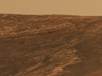
This approximate true-color image taken by the panoramic camera on the Mars Exploration Rover Opportunity highlights a feature called "Karatepe" within the impact crater known as "Endurance." Scientists believe this layered band of rock may be a good place to begin studying Endurance because it is less steep and more approachable than the rest of the crater's rocky outcrops.

This image is a portion of a larger mosaic taken with the panoramic camera's 480-, 530- and 750-nanometer filters on sols 97 and 98.


Signaler ce message à un modérateur | IP: Logguée
Temps en ligne : 8 Jours, 15 Heures, 44 Minutes, 21 Secondes en ligne

Old Post 07-05-2004 02:55
Cliquez ici pour voir le profil de Seth Cliquez ici pour lui envoyer un message privé  Trouver plus de messages de Seth Ajouter Seth à votre liste d'amis Editer/Effacer le Message Citer le message dans la réponse
 Seth  Rechercher tous les messages de ce membre Cliquez ici pour envoyer un message privé à cet utilisateur
Confirmé

Déconnecté

Niveau : 3
N° de Membre : 1512

Ancienneté : 100%
Participation : 2%
Inscription: 07 May 2002
Localisation:
Messages: 1390
Sujets Lancés : 70


http://photojournal.jpl.nasa.gov/jp...5872_modest.jpg

Citation:
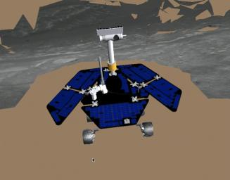
This image shows the Mars Exploration Rover Opportunity at the end of its sol 95 drive to the edge of "Endurance Crater." The rover stopped within 40 centimeters (15.7 inches) of the crater's edge on its first approach, seen in this image. The terrain model in this image was generated with a special software program called the Rover Sequencing and Visualization Program. The program is used by rover drivers to simulate and safely plan the rover's approach path. Blank areas in the image denote missing data.


Signaler ce message à un modérateur | IP: Logguée
Temps en ligne : 8 Jours, 15 Heures, 44 Minutes, 21 Secondes en ligne

Old Post 07-05-2004 02:56
Cliquez ici pour voir le profil de Seth Cliquez ici pour lui envoyer un message privé  Trouver plus de messages de Seth Ajouter Seth à votre liste d'amis Editer/Effacer le Message Citer le message dans la réponse
 Seth  Rechercher tous les messages de ce membre Cliquez ici pour envoyer un message privé à cet utilisateur
Confirmé

Déconnecté

Niveau : 3
N° de Membre : 1512

Ancienneté : 100%
Participation : 2%
Inscription: 07 May 2002
Localisation:
Messages: 1390
Sujets Lancés : 70


Citation:
This map illustrates the Mars Exploration Rover Spirit's position as of sol 112 (April 26, 2004), near the crater called "Missoula." Like a train on a tight schedule, Spirit will make regular stops along the way to its ultimate destination, the "Columbia Hills." At each stop, or "station," the rover will briefly analyze the area's rocks and soils. Each tick mark on the rover's route represents one sol's worth of travel, or about 60 to 70 meters (200 to 230 feet). Rover planners estimate that Spirit will reach the hills around mid-June. Presently, the rover is stopped at a site called "Plains Station."

The color thermal data show how well different surface features hold onto heat. Red indicates warmth; blue indicates coolness. Areas with higher temperatures are more likely to be rocky, as rocks absorb heat. Lower temperatures denote small particles and fewer rocks. During its traverse, Spirit will document the causes of these temperature variations.

The map comprises data from the camera on NASA's Mars Global Surveyor orbiter and the thermal emission imaging system on NASA's Mars Odyssey orbiter.


Signaler ce message à un modérateur | IP: Logguée
Temps en ligne : 8 Jours, 15 Heures, 44 Minutes, 21 Secondes en ligne

Old Post 07-05-2004 02:56
Cliquez ici pour voir le profil de Seth Cliquez ici pour lui envoyer un message privé  Trouver plus de messages de Seth Ajouter Seth à votre liste d'amis Editer/Effacer le Message Citer le message dans la réponse
 Seth  Rechercher tous les messages de ce membre Cliquez ici pour envoyer un message privé à cet utilisateur
Confirmé

Déconnecté

Niveau : 3
N° de Membre : 1512

Ancienneté : 100%
Participation : 2%
Inscription: 07 May 2002
Localisation:
Messages: 1390
Sujets Lancés : 70


http://photojournal.jpl.nasa.gov/jp...5874_modest.jpg
PIA05874.tif (3.777 MB) http://photojournal.jpl.nasa.gov/tiff/PIA05874.tif

Citation:
This animation shows the Mars Exploration Rover Spirit's ultimate target, the "Columbia Hills," from various angles including a Spirit's-eye-view, a fly-over view, a horizon view and a counterclockwise view circling to the south and north of the hills. The Columbia Hills are an intriguing target because they are older than the plains and may give scientists more clues to Mars' past. To successfully reach and examine the hills, Spirit must continue to perform above the original expectations of scientists and engineers. The elevation model in this animation was made using two images from the camera onboard NASA's Mars Global Surveyor.


Signaler ce message à un modérateur | IP: Logguée
Temps en ligne : 8 Jours, 15 Heures, 44 Minutes, 21 Secondes en ligne

Old Post 07-05-2004 02:57
Cliquez ici pour voir le profil de Seth Cliquez ici pour lui envoyer un message privé  Trouver plus de messages de Seth Ajouter Seth à votre liste d'amis Editer/Effacer le Message Citer le message dans la réponse
 Solacin  Rechercher tous les messages de ce membre Cliquez ici pour envoyer un message privé à cet utilisateur
Guru

Déconnecté

Niveau : 5
N° de Membre : 11117

Ancienneté : 96%
Participation : 10%
Inscription: 23 Mar 2003
Localisation: 974
Age: 52
Messages: 8253
Sujets Lancés : 28

Oooooooooooooh, pas mal cette image en volume


__________________


Signaler ce message à un modérateur | IP: Logguée
Temps en ligne : 25 Jours, 5 Heures, 18 Minutes, 53 Secondes en ligne

Old Post 07-05-2004 05:43
Cliquez ici pour voir le profil de Solacin Cliquez ici pour lui envoyer un message privé  Trouver plus de messages de Solacin Ajouter Solacin à votre liste d'amis       Editer/Effacer le Message Citer le message dans la réponse
 shakes808080  Rechercher tous les messages de ce membre Cliquez ici pour envoyer un message privé à cet utilisateur
Guru

Déconnecté

Niveau : 5
N° de Membre : 517

Ancienneté : 100%
Participation : 11%
Inscription: 08 Mar 2002
Localisation:
Messages: 8978
Sujets Lancés : 354

UN AN DEJA!!!!

Le topic est resté à l'abandon, mais les deux petits robots sont toujours actifs et continuent leur mission.

Retrouvez un résumé en image (et en français) de toute l'année pour spirit et pour opportunity sur le site de http://www.nirgal.net


__________________
Racket logiciel


Signaler ce message à un modérateur | IP: Logguée
Temps en ligne : 45 Jours, 5 Heures, 55 Minutes, 7 Secondes en ligne

Old Post 02-03-2005 14:17
Cliquez ici pour voir le profil de shakes808080 Cliquez ici pour lui envoyer un message privé  Trouver plus de messages de shakes808080 Ajouter shakes808080 à votre liste d'amis Editer/Effacer le Message Citer le message dans la réponse
Il est actuellement 13:45 (GMT) Poster un nouveau sujet    Poster une réponse   
Page(s) (49): [ <<   <   38   39   40   41   42   43   44   45   46   47   48   49   > ]  Sujet précédent   Sujet suivant
Forum OXMO > Section Généraliste > Discussion Libre > Je vous parle en direct de Mars (Opportunity a atterri !)

Aller au Forum:
Notez ce sujet :


 Réponse Rapide
Titre: (Optionnel)
Message:

Convertir automatiquement les URLs Montrer la Signature
Afficher une version imprimable | Envoyer cette page par email | S'inscrire à ce sujet | Télécharger ce sujet
Règles du forum :
Créer de nouveaux sujets
Répondre aux messages
Attacher des fichiers
Editer vos messages
: not autorisé
: not autorisé
: not autorisé
: not autorisé
Le Code HTML est OFF
Le Code vB est ON
Les Smileys sont ONs
Le code [IMG] est ON
 
< Contactez-nous - Forum OXMO>

Uptime du serveur SQL : 2 jour(s) 13 heure(s) et 21 minute(s)
Page générée en 0.025518 secondes en exécutant 42 requêtes SQL.
Apache - Compression GZIP : Activée.